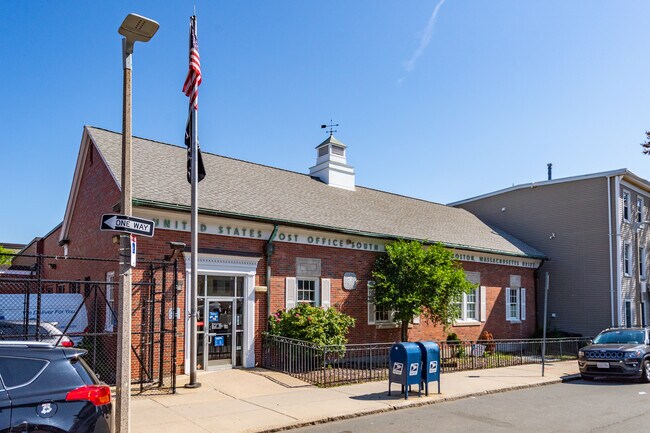
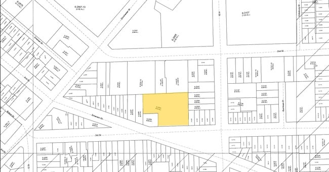
Property Record
444 E 3Rd St, South Boston, MA 02127

NEARBY LISTINGS FOR SALE OR LEASE
-
-
-
-
No Photo
-
-
View all South Boston listings for sale on LoopNet.com
Property Detail
444 E 3Rd St
SBOS-000000-000006-003053
South Boston
Uspostalservice
Suffolk
X
Massachusetts
25025C0083J
0.43 AC
2025
South Boston
2025
Boston
060501
Boston-Cambridge-Newton, MA-NH
9,240 SF
DEMOGRAPHICS near 444 E 3Rd St
1 Mile
3 Mile
5 Mile
2024 Total Population
41,235
328,590
770,549
2029 Population
39,732
316,023
740,749
Pop Growth 2024-2029
(3.64%)
(3.82%)
(3.87%)
Average Age
36
37
37
2024 Total Households
20,051
144,770
319,202
HH Growth 2024-2029
(3.88%)
(4.00%)
(4.07%)
Median Household Inc
$139,355
$86,255
$86,527
Avg Household Size
2.00
2.00
2.20
2024 Avg HH Vehicles
1.00
1.00
1.00
Median Home Value
$781,785
$826,112
$776,549
Median Year Built
1967
1956
1949
Nearby Places
Map Layers
Map Styles
 Street
 Aerial
- Restaurants
- Banks
- Shops
- Fitness
- Groceries
PUBLIC TRANSPORTATION
TRANSIT/SUBWAY
Dry Dock Ave- Design Center Pl (Silver Line 2 - Massachusetts Bay Transportation Authority Subway (The T))
DRIVE
WALK
Distance
Dry Dock Ave- Design Center Pl (Silver Line 2 - Massachusetts Bay Transportation Authority Subway (The T))
4 min
19 min
1.0 mi
Dry Dock and Design Center (Silver Line 2 - Massachusetts Bay Transportation Authority Subway (The T))
DRIVE
WALK
Distance
Dry Dock and Design Center (Silver Line 2 - Massachusetts Bay Transportation Authority Subway (The T))
19 min
1.0 mi
Black Falcon Ave- Design Center Pl (Silver Line 2 - Massachusetts Bay Transportation Authority Subway (The T))
DRIVE
WALK
Distance
Black Falcon Ave- Design Center Pl (Silver Line 2 - Massachusetts Bay Transportation Authority Subway (The T))
4 min
19 min
1.0 mi
COMMUTER RAIL
South Station (Fairmount Line - Massachusetts Bay Transportation Authority Commuter Rail (Purple Line), Framingham/Worcester Line - Massachusetts Bay Transportation Authority Commuter Rail (Purple Line), Franklin Line - Massachusetts Bay Transportation Authority Commuter Rail (Purple Line), Greenbush Line - Massachusetts Bay Transportation Authority Commuter Rail (Purple Line), Kingston/Plymouth Line - Massachusetts Bay Transportation Authority Commuter Rail (Purple Line), Middleborough/Lakeville Line - Massachusetts Bay Transportation Authority Commuter Rail (Purple Line), Needham Line - Massachusetts Bay Transportation Authority Commuter Rail (Purple Line), Providence/Stoughton Line - Massachusetts Bay Transportation Authority Commuter Rail (Purple Line))
DRIVE
WALK
Distance
South Station (Fairmount Line - Massachusetts Bay Transportation Authority Commuter Rail (Purple Line), Framingham/Worcester Line - Massachusetts Bay Transportation Authority Commuter Rail (Purple Line), Franklin Line - Massachusetts Bay Transportation Authority Commuter Rail (Purple Line), Greenbush Line - Massachusetts Bay Transportation Authority Commuter Rail (Purple Line), Kingston/Plymouth Line - Massachusetts Bay Transportation Authority Commuter Rail (Purple Line), Middleborough/Lakeville Line - Massachusetts Bay Transportation Authority Commuter Rail (Purple Line), Needham Line - Massachusetts Bay Transportation Authority Commuter Rail (Purple Line), Providence/Stoughton Line - Massachusetts Bay Transportation Authority Commuter Rail (Purple Line))
6 min
1.8 mi
Uphams Corner (Fairmount Line - Massachusetts Bay Transportation Authority Commuter Rail (Purple Line))
DRIVE
WALK
Distance
Uphams Corner (Fairmount Line - Massachusetts Bay Transportation Authority Commuter Rail (Purple Line))
8 min
2.0 mi
AIRPORT
General Edward Lawrence Logan International
DRIVE
WALK
Distance
General Edward Lawrence Logan International
10 min
5.0 mi
Freight Ports
Port of Boston
DRIVE
WALK
Distance
Port of Boston
1 min
1.1 mi
SALE & LEASE HISTORY
LISTING DATE
SALE/LEASE

Jun 12, 2025
For Sale
Nearby Properties
Address
Land Use
TOTAL SIZE
Lot Size
Zoning
Address
Land Use
TOTAL SIZE
Lot Size
Zoning
909,764 SF
25.13 AC
E
Address
Land Use
TOTAL SIZE
Lot Size
Zoning
610,560 SF
4.01 AC
E
Address
Land Use
TOTAL SIZE
Lot Size
Zoning
408,667 SF
3.27 AC
C
Address
Land Use
TOTAL SIZE
Lot Size
Zoning
825,000 SF
5.17 AC
E
Address
Land Use
TOTAL SIZE
Lot Size
Zoning
6.39 AC
C
Address
Land Use
TOTAL SIZE
Lot Size
Zoning
596,972 SF
7.32 AC
E
Address
Land Use
TOTAL SIZE
Lot Size
Zoning
171,791 SF
166.88 AC
E
Address
Land Use
TOTAL SIZE
Lot Size
Zoning
334,522 SF
1.26 AC
C
Address
Land Use
TOTAL SIZE
Lot Size
Zoning
312,269 SF
0.43 AC
C
Address
Land Use
TOTAL SIZE
Lot Size
Zoning
230,394 SF
0.60 AC
MXD
Address
Land Use
TOTAL SIZE
Lot Size
Zoning
46,259 SF
1.05 AC
E
Address
Land Use
TOTAL SIZE
Lot Size
Zoning
118,759 SF
0.92 AC
C
Address
Land Use
TOTAL SIZE
Lot Size
Zoning
377,634 SF
4.86 AC
E
Address
Land Use
TOTAL SIZE
Lot Size
Zoning
1.13 AC
C
Address
Land Use
TOTAL SIZE
Lot Size
Zoning
3.75 AC
C
Address
Land Use
TOTAL SIZE
Lot Size
Zoning
227,107 SF
7.70 AC
E
Address
Land Use
TOTAL SIZE
Lot Size
Zoning
448,796 SF
1.84 AC
C
Address
Land Use
TOTAL SIZE
Lot Size
Zoning
341,500 SF
1.18 AC
RC
Address
Land Use
TOTAL SIZE
Lot Size
Zoning
252,392 SF
0.52 AC
C
Address
Land Use
TOTAL SIZE
Lot Size
Zoning
325,020 SF
0.62 AC
RC
Address
Land Use
TOTAL SIZE
Lot Size
Zoning
237,935 SF
1.27 AC
C-3
Address
Land Use
TOTAL SIZE
Lot Size
Zoning
619,050 SF
0.45 AC
C
Address
Land Use
TOTAL SIZE
Lot Size
Zoning
259,990 SF
2.84 AC
E
Address
Land Use
TOTAL SIZE
Lot Size
Zoning
6.14 AC
C
Address
Land Use
TOTAL SIZE
Lot Size
Zoning
547,851 SF
8.14 AC
E
Address
Land Use
TOTAL SIZE
Lot Size
Zoning
305,455 SF
0.54 AC
RC
Address
Land Use
TOTAL SIZE
Lot Size
Zoning
138,316 SF
0.19 AC
RC
Address
Land Use
TOTAL SIZE
Lot Size
Zoning
401,310 SF
1.32 AC
C
Address
Land Use
TOTAL SIZE
Lot Size
Zoning
526,171 SF
8.39 AC
A
Address
Land Use
TOTAL SIZE
Lot Size
Zoning
157,083 SF
0.41 AC
C
The World's #1 Commercial Real Estate Marketplace
Connect with us
© 2026 CoStar Group
The information above has been obtained from sources believed reliable. While we do not doubt its accuracy we have not verified it and make no guarantee, warranty or representation about it. It is your responsibility to independently confirm its accuracy and completeness. Any projections, opinions, assumptions, or estimates used are for example only and do not represent the current or future performance of the property. The value of this transaction to you depends on tax and other factors which should be evaluated by your tax, financial, and legal advisors. You and your advisors should conduct a careful, independent investigation of the property to determine to your satisfaction the suitability of the property for your needs.