Property Record
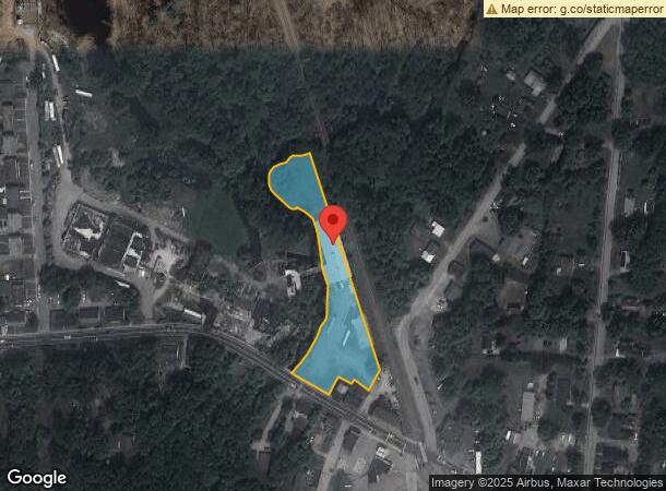
444 Hartford Pike, Dayville, CT 06241
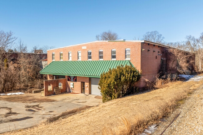
This Property Is For Sale
NEARBY LISTINGS FOR SALE OR LEASE
Property Detail
444 Hartford Pike
Multipleuses
Windham
AE
Connecticut
09015C0232F
1.50 AC
2025
Windham County
2025
Hartford
904400
Worcester, MA-CT
20,712 SF
KILL-000107-000000-000068
DEMOGRAPHICS near 444 Hartford Pike
1 Mile
3 Mile
5 Mile
2024 Total Population
1,578
11,812
27,058
2029 Population
1,528
11,806
27,019
Pop Growth 2024-2029
(3.17%)
(0.05%)
(0.14%)
Average Age
40
42
42
2024 Total Households
652
4,848
10,920
HH Growth 2024-2029
(3.07%)
+ 0.04%
(0.10%)
Median Household Inc
$72,230
$74,324
$73,294
Avg Household Size
2.40
2.30
2.40
2024 Avg HH Vehicles
2.00
2.00
2.00
Median Home Value
$265,573
$234,242
$240,195
Median Year Built
1970
1966
1967
Nearby Places
Map Layers
Map Styles
 Street
 Aerial
- Restaurants
- Banks
- Shops
- Fitness
- Groceries
PUBLIC TRANSPORTATION
AIRPORT
Rhode Island Tf Green International
DRIVE
WALK
Distance
Rhode Island Tf Green International
48 min
31.5 mi
Worcester Regional
DRIVE
WALK
Distance
Worcester Regional
48 min
33.9 mi
Freight Ports
Port of Davisville, RI
DRIVE
WALK
Distance
Port of Davisville, RI
60 min
40.7 mi
Nearby Properties
Address
Land Use
TOTAL SIZE
Lot Size
Zoning
Address
Land Use
TOTAL SIZE
Lot Size
Zoning
141.59 AC
RD
Address
Land Use
TOTAL SIZE
Lot Size
Zoning
86 AC
LD
Address
Land Use
TOTAL SIZE
Lot Size
Zoning
203,150 SF
21 AC
LD
Address
Land Use
TOTAL SIZE
Lot Size
Zoning
Address
Land Use
TOTAL SIZE
Lot Size
Zoning
62 AC
LD
Address
Land Use
TOTAL SIZE
Lot Size
Zoning
47 AC
MUI
Address
Land Use
TOTAL SIZE
Lot Size
Zoning
53,306 SF
1.60 AC
BI
Address
Land Use
TOTAL SIZE
Lot Size
Zoning
447,300 SF
32.08 AC
I
Address
Land Use
TOTAL SIZE
Lot Size
Zoning
139,010 SF
16.75 AC
MUI
Address
Land Use
TOTAL SIZE
Lot Size
Zoning
307,858 SF
52 AC
I
Address
Land Use
TOTAL SIZE
Lot Size
Zoning
227 AC
LD
Address
Land Use
TOTAL SIZE
Lot Size
Zoning
29.78 AC
I
Address
Land Use
TOTAL SIZE
Lot Size
Zoning
169.79 AC
ALZ.L
Address
Land Use
TOTAL SIZE
Lot Size
Zoning
148,118 SF
17 AC
BRHD
Address
Land Use
TOTAL SIZE
Lot Size
Zoning
126,601 SF
13.40 AC
MUI
Address
Land Use
TOTAL SIZE
Lot Size
Zoning
210,670 SF
20.74 AC
I
Address
Land Use
TOTAL SIZE
Lot Size
Zoning
864 SF
50 AC
VC/LD
Address
Land Use
TOTAL SIZE
Lot Size
Zoning
6.61 AC
MUI
Address
Land Use
TOTAL SIZE
Lot Size
Zoning
131,792 SF
18.69 AC
I
Address
Land Use
TOTAL SIZE
Lot Size
Zoning
59,552 SF
4.28 AC
GC
Address
Land Use
TOTAL SIZE
Lot Size
Zoning
20,644 SF
80.30 AC
AG-2
Address
Land Use
TOTAL SIZE
Lot Size
Zoning
50,707 SF
10.50 AC
BRHD
Address
Land Use
TOTAL SIZE
Lot Size
Zoning
7.07 AC
GC
Address
Land Use
TOTAL SIZE
Lot Size
Zoning
44,160 SF
5.82 AC
RD
Address
Land Use
TOTAL SIZE
Lot Size
Zoning
9.09 AC
I
Address
Land Use
TOTAL SIZE
Lot Size
Zoning
173,650 SF
26.63 AC
I
Address
Land Use
TOTAL SIZE
Lot Size
Zoning
89,872 SF
6.71 AC
LD
Address
Land Use
TOTAL SIZE
Lot Size
Zoning
10.50 AC
GC
Address
Land Use
TOTAL SIZE
Lot Size
Zoning
40,240 SF
1.84 AC
GC
Address
Land Use
TOTAL SIZE
Lot Size
Zoning
85,301 SF
47.97 AC
I
The World's #1 Commercial Real Estate Marketplace
Connect with us
© 2026 CoStar Group
The information above has been obtained from sources believed reliable. While we do not doubt its accuracy we have not verified it and make no guarantee, warranty or representation about it. It is your responsibility to independently confirm its accuracy and completeness. Any projections, opinions, assumptions, or estimates used are for example only and do not represent the current or future performance of the property. The value of this transaction to you depends on tax and other factors which should be evaluated by your tax, financial, and legal advisors. You and your advisors should conduct a careful, independent investigation of the property to determine to your satisfaction the suitability of the property for your needs.