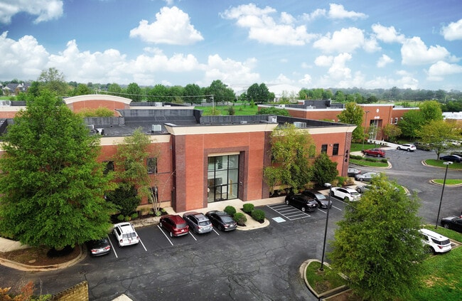
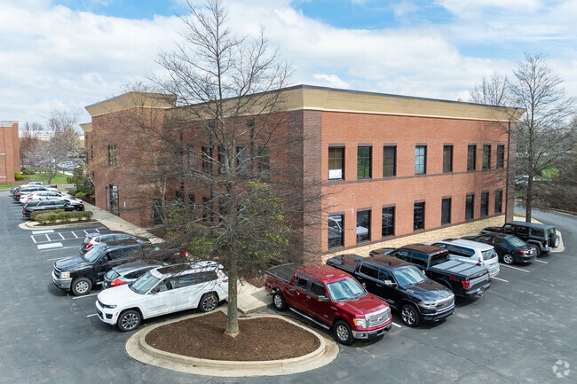
Property Record
444 Lewis Hargett Cir, Lexington, KY 40503
NEARBY LISTINGS FOR SALE OR LEASE
Property Detail
444 Lewis Hargett Cir
38293190
Ndc-Wellington
Officecondo
Fayette
2025
Kentucky
2025
West Lexington/Fayette
004204
Lexington/Fayette
4,973 SF
Lexington-Fayette, KY
DEMOGRAPHICS near 444 Lewis Hargett Cir
1 Mile
3 Mile
5 Mile
2024 Total Population
7,522
102,170
215,789
2029 Population
7,436
101,710
215,622
Pop Growth 2024-2029
(1.14%)
(0.45%)
(0.08%)
Average Age
41
40
38
2024 Total Households
3,194
44,783
92,330
HH Growth 2024-2029
(1.22%)
(0.48%)
(0.08%)
Median Household Inc
$67,843
$66,506
$59,093
Avg Household Size
2.30
2.20
2.20
2024 Avg HH Vehicles
2.00
2.00
2.00
Median Home Value
$228,853
$260,175
$267,317
Median Year Built
1973
1980
1979
Nearby Places
Map Layers
Map Styles
 Street
 Aerial
- Restaurants
- Banks
- Shops
- Fitness
- Groceries
PUBLIC TRANSPORTATION
AIRPORT
Blue Grass
DRIVE
WALK
Distance
Blue Grass
18 min
8.9 mi
SALE & LEASE HISTORY
LISTING DATE
SALE/LEASE

Oct 08, 2020
For Sale
May 06, 2025
For Lease
Mar 13, 2018
For Lease
Mar 05, 2025
For Sale
Jul 17, 2018
For Lease
Feb 24, 2025
For Lease
Feb 20, 2024
For Sale
Nearby Properties
Address
Land Use
TOTAL SIZE
Lot Size
Zoning
Address
Land Use
TOTAL SIZE
Lot Size
Zoning
635,961 SF
23.52 AC
P-1
Address
Land Use
TOTAL SIZE
Lot Size
Zoning
510,633 SF
15.10 AC
P-1
Address
Land Use
TOTAL SIZE
Lot Size
Zoning
372,139 SF
4.82 AC
R-4
Address
Land Use
TOTAL SIZE
Lot Size
Zoning
582.34 AC
A-U
Address
Land Use
TOTAL SIZE
Lot Size
Zoning
319,500 SF
0.25 AC
P-1
Address
Land Use
TOTAL SIZE
Lot Size
Zoning
318,370 SF
17.79 AC
B-6P
Address
Land Use
TOTAL SIZE
Lot Size
Zoning
292,730 SF
3.18 AC
R-1C
Address
Land Use
TOTAL SIZE
Lot Size
Zoning
4,299 SF
18.43 AC
R-4
Address
Land Use
TOTAL SIZE
Lot Size
Zoning
263,090 SF
37.66 AC
A-U
Address
Land Use
TOTAL SIZE
Lot Size
Zoning
8,001 SF
32.59 AC
MU-3
Address
Land Use
TOTAL SIZE
Lot Size
Zoning
144,866 SF
14.83 AC
B-6P
Address
Land Use
TOTAL SIZE
Lot Size
Zoning
238,393 SF
9.83 AC
B-6P
Address
Land Use
TOTAL SIZE
Lot Size
Zoning
22.10 AC
R-3
Address
Land Use
TOTAL SIZE
Lot Size
Zoning
41,040 SF
14.77 AC
R-4
Address
Land Use
TOTAL SIZE
Lot Size
Zoning
184,756 SF
4.43 AC
MU-3
Address
Land Use
TOTAL SIZE
Lot Size
Zoning
91,484 SF
14.72 AC
B-6P
Address
Land Use
TOTAL SIZE
Lot Size
Zoning
7,402 SF
18.83 AC
R-4
Address
Land Use
TOTAL SIZE
Lot Size
Zoning
2,968 SF
14.26 AC
R-3
Address
Land Use
TOTAL SIZE
Lot Size
Zoning
137,905 SF
23.79 AC
B-6P
Address
Land Use
TOTAL SIZE
Lot Size
Zoning
97,729 SF
4.22 AC
P-1
Address
Land Use
TOTAL SIZE
Lot Size
Zoning
10.41 AC
R-3
Address
Land Use
TOTAL SIZE
Lot Size
Zoning
6.25 AC
A-U
Address
Land Use
TOTAL SIZE
Lot Size
Zoning
14,292 SF
11.32 AC
R-4
Address
Land Use
TOTAL SIZE
Lot Size
Zoning
23,042 SF
8.90 AC
R-4
Address
Land Use
TOTAL SIZE
Lot Size
Zoning
123,221 SF
17.32 AC
R-1B
Address
Land Use
TOTAL SIZE
Lot Size
Zoning
28,776 SF
13.83 AC
B-1
Address
Land Use
TOTAL SIZE
Lot Size
Zoning
73,590 SF
13.31 AC
R-1T
Address
Land Use
TOTAL SIZE
Lot Size
Zoning
78,675 SF
2.12 AC
P-1
Address
Land Use
TOTAL SIZE
Lot Size
Zoning
25,880 SF
0.78 AC
P-1
Address
Land Use
TOTAL SIZE
Lot Size
Zoning
222,168 SF
26.49 AC
B-6P
The World's #1 Commercial Real Estate Marketplace
Connect with us
© 2025 CoStar Group
The information above has been obtained from sources believed reliable. While we do not doubt its accuracy we have not verified it and make no guarantee, warranty or representation about it. It is your responsibility to independently confirm its accuracy and completeness. Any projections, opinions, assumptions, or estimates used are for example only and do not represent the current or future performance of the property. The value of this transaction to you depends on tax and other factors which should be evaluated by your tax, financial, and legal advisors. You and your advisors should conduct a careful, independent investigation of the property to determine to your satisfaction the suitability of the property for your needs.