Property Record
444 Lewis St, Pagosa Springs, CO 81147
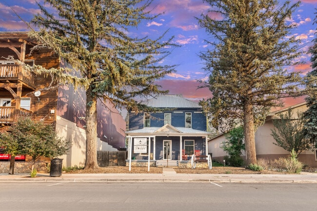
This Property Is For Sale
NEARBY LISTINGS FOR SALE OR LEASE
-
-
View all Pagosa Springs listings for sale on LoopNet.com
Property Detail
444 Lewis St
Other Market Areas
Town Of Pagosa Spgs
569913303017
Archuleta
Sfr
Colorado
X
0.26 AC
08007C0269D
Colorado Southwest Area
399 SF
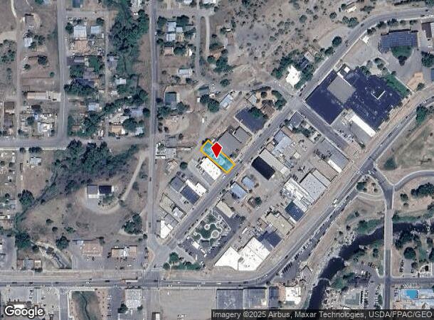
DEMOGRAPHICS near 444 Lewis St
1 Mile
3 Mile
5 Mile
2024 Total Population
966
2,382
8,088
2029 Population
1,129
2,815
9,704
Pop Growth 2024-2029
+ 16.87%
+ 18.18%
+ 19.98%
Average Age
46
46
47
2024 Total Households
399
1,007
3,539
HH Growth 2024-2029
+ 17.04%
+ 18.47%
+ 20.20%
Median Household Inc
$65,571
$66,400
$79,567
Avg Household Size
2.40
2.30
2.20
2024 Avg HH Vehicles
2.00
2.00
2.00
Median Home Value
$517,500
$517,276
$476,868
Median Year Built
1990
1991
1995
Nearby Places
Map Layers
Map Styles
 Street
 Aerial
- Restaurants
- Banks
- Shops
- Fitness
- Groceries
Nearby Properties
Address
Land Use
TOTAL SIZE
Lot Size
Zoning
Address
Land Use
TOTAL SIZE
Lot Size
Zoning
PUBLIC/QUA
Address
Land Use
TOTAL SIZE
Lot Size
Zoning
PUBLIC/QUA
Address
Land Use
TOTAL SIZE
Lot Size
Zoning
35,811 SF
3 AC
MIXED-USE
Address
Land Use
TOTAL SIZE
Lot Size
Zoning
26.50 AC
OPEN SPACE
Address
Land Use
TOTAL SIZE
Lot Size
Zoning
47,570 SF
6.97 AC
PUBLIC/QUA
Address
Land Use
TOTAL SIZE
Lot Size
Zoning
8,155 SF
3 AC
MIXED-USE
Address
Land Use
TOTAL SIZE
Lot Size
Zoning
15,960 SF
362.64 AC
INDUSTRIAL
Address
Land Use
TOTAL SIZE
Lot Size
Zoning
32.48 AC
OPEN SPACE
Address
Land Use
TOTAL SIZE
Lot Size
Zoning
Address
Land Use
TOTAL SIZE
Lot Size
Zoning
3,480 SF
15.53 AC
OPEN SPACE
Address
Land Use
TOTAL SIZE
Lot Size
Zoning
2,690 SF
4.98 AC
MIXED-USE
Address
Land Use
TOTAL SIZE
Lot Size
Zoning
10.61 AC
MIXED-USE
Address
Land Use
TOTAL SIZE
Lot Size
Zoning
552.73 AC
AGRICULTUR
Address
Land Use
TOTAL SIZE
Lot Size
Zoning
PUBLIC/QUA
Address
Land Use
TOTAL SIZE
Lot Size
Zoning
3,316 SF
1.21 AC
MIXED-USE
Address
Land Use
TOTAL SIZE
Lot Size
Zoning
1,712 SF
68.11 AC
AGRICULTUR
Address
Land Use
TOTAL SIZE
Lot Size
Zoning
AGRICULTUR
Address
Land Use
TOTAL SIZE
Lot Size
Zoning
2,176 SF
38.13 AC
AGRICULTUR
Address
Land Use
TOTAL SIZE
Lot Size
Zoning
15,857 SF
0.63 AC
MIXED-USE
Address
Land Use
TOTAL SIZE
Lot Size
Zoning
6,748 SF
1.66 AC
MIXED-USE
Address
Land Use
TOTAL SIZE
Lot Size
Zoning
MIXED-USE
Address
Land Use
TOTAL SIZE
Lot Size
Zoning
420 SF
2.07 AC
OPEN SPACE
Address
Land Use
TOTAL SIZE
Lot Size
Zoning
13,862 SF
0.74 AC
PUBLIC/QUA
Address
Land Use
TOTAL SIZE
Lot Size
Zoning
8,228 SF
3.29 AC
PUBLIC/QUA
Address
Land Use
TOTAL SIZE
Lot Size
Zoning
65,245 SF
15.02 AC
PUBLIC/QUA
Address
Land Use
TOTAL SIZE
Lot Size
Zoning
PUBLIC/QUA
Address
Land Use
TOTAL SIZE
Lot Size
Zoning
22,125 SF
3.57 AC
MIXED-USE
Address
Land Use
TOTAL SIZE
Lot Size
Zoning
6,344 SF
0.77 AC
MIXED-USE
Address
Land Use
TOTAL SIZE
Lot Size
Zoning
24,000 SF
0.86 AC
MIXED-USE
Address
Land Use
TOTAL SIZE
Lot Size
Zoning
6,840 SF
3.99 AC
PUBLIC/QUA
The World's #1 Commercial Real Estate Marketplace
Connect with us
© 2026 CoStar Group
The information above has been obtained from sources believed reliable. While we do not doubt its accuracy we have not verified it and make no guarantee, warranty or representation about it. It is your responsibility to independently confirm its accuracy and completeness. Any projections, opinions, assumptions, or estimates used are for example only and do not represent the current or future performance of the property. The value of this transaction to you depends on tax and other factors which should be evaluated by your tax, financial, and legal advisors. You and your advisors should conduct a careful, independent investigation of the property to determine to your satisfaction the suitability of the property for your needs.