Property Record
444 S Main St, Kewanee, IL 61443


Property Detail
444 S Main St
Davenport-Moline-Rock Island, IA-IL
LOT 1 KEWANEE, IL RX SUB [EZ]
20-33-406-028
Henry
Commercialnec
Illinois
B and X Area of moderate flood hazard, usually the area between the limits of the 100-year and 500-year floods.
1
2024
1.12 AC
2024
Henry County
030900
Davenport/Moline/Rock Island
13,419 SF
NEARBY LISTINGS FOR SALE OR LEASE
-
-
View all Kewanee listings for sale on LoopNet.com
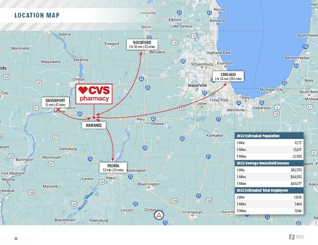
DEMOGRAPHICS near 444 S Main St
1 mile
3 mile
5 mile
2025 Total Population
9,401
13,870
14,256
2030 Population
9,410
13,926
14,311
Pop Growth 2025-2030
+ 0.10%
+ 0.40%
+ 0.39%
Average Age
41
41
41
2025 Total Households
3,903
5,689
5,854
HH Growth 2025-2030
+ 0.08%
+ 0.39%
+ 0.36%
Median Household Inc
$52,507
$51,840
$52,744
Avg Household Size
2.30
2.30
2.30
2025 Avg HH Vehicles
2.00
2.00
2.00
Median Home Value
$70,344
$73,857
$75,447
Median Year Built
1948
1950
1950
Nearby Places
Map Layers
Map Styles
 Street
 Aerial
Layers
 Traffic
 Biking
Places
Listings with unknown addresses are not visible on the map
- Restaurants
- Banks
- Shops
- Fitness
- Groceries
PUBLIC TRANSPORTATION
COMMUTER RAIL
Drive
Walk
Distance
2 min
13 min
0.7 mi
AIRPORT
Quad Cities International
Drive
Walk
Distance
Quad Cities International
63 min
46.0 mi
SALE & LEASE HISTORY
LISTING DATE
SALE/LEASE

Sep 21, 2022
For Sale
Nearby Properties
Address
Land Use
TOTAL SIZE
Lot Size
Zoning
Address
Land Use
TOTAL SIZE
Lot Size
Zoning
29.03 AC
Address
Land Use
TOTAL SIZE
Lot Size
Zoning
17.57 AC
Address
Land Use
TOTAL SIZE
Lot Size
Zoning
0.44 AC
Address
Land Use
TOTAL SIZE
Lot Size
Zoning
1 SF
16.97 AC
Address
Land Use
TOTAL SIZE
Lot Size
Zoning
2.59 AC
Address
Land Use
TOTAL SIZE
Lot Size
Zoning
0.83 AC
Address
Land Use
TOTAL SIZE
Lot Size
Zoning
0.45 AC
Address
Land Use
TOTAL SIZE
Lot Size
Zoning
6.50 AC
Address
Land Use
TOTAL SIZE
Lot Size
Zoning
3.12 AC
Address
Land Use
TOTAL SIZE
Lot Size
Zoning
1.58 AC
Address
Land Use
TOTAL SIZE
Lot Size
Zoning
1.91 AC
Address
Land Use
TOTAL SIZE
Lot Size
Zoning
25,430 SF
2.46 AC
Address
Land Use
TOTAL SIZE
Lot Size
Zoning
50.22 AC
Address
Land Use
TOTAL SIZE
Lot Size
Zoning
17,359 SF
1.93 AC
Address
Land Use
TOTAL SIZE
Lot Size
Zoning
65,600 SF
4 AC
Address
Land Use
TOTAL SIZE
Lot Size
Zoning
1.41 AC
Address
Land Use
TOTAL SIZE
Lot Size
Zoning
3.84 AC
Address
Land Use
TOTAL SIZE
Lot Size
Zoning
10.35 AC
Address
Land Use
TOTAL SIZE
Lot Size
Zoning
Address
Land Use
TOTAL SIZE
Lot Size
Zoning
19,900 SF
40.13 AC
Address
Land Use
TOTAL SIZE
Lot Size
Zoning
0.81 AC
Address
Land Use
TOTAL SIZE
Lot Size
Zoning
4,600 SF
10.52 AC
Address
Land Use
TOTAL SIZE
Lot Size
Zoning
18,731 SF
3.62 AC
Address
Land Use
TOTAL SIZE
Lot Size
Zoning
2.23 AC
Address
Land Use
TOTAL SIZE
Lot Size
Zoning
4.26 AC
Address
Land Use
TOTAL SIZE
Lot Size
Zoning
2,288 SF
1.25 AC
Address
Land Use
TOTAL SIZE
Lot Size
Zoning
11,357 SF
1.26 AC
Address
Land Use
TOTAL SIZE
Lot Size
Zoning
0.59 AC
Address
Land Use
TOTAL SIZE
Lot Size
Zoning
0.86 AC
The World's #1 Commercial Real Estate Marketplace
Connect with us
© 2026 CoStar Group
The information above has been obtained from sources believed reliable. While we do not doubt its accuracy we have not verified it and make no guarantee, warranty or representation about it. It is your responsibility to independently confirm its accuracy and completeness. Any projections, opinions, assumptions, or estimates used are for example only and do not represent the current or future performance of the property. The value of this transaction to you depends on tax and other factors which should be evaluated by your tax, financial, and legal advisors. You and your advisors should conduct a careful, independent investigation of the property to determine to your satisfaction the suitability of the property for your needs.