Property Record
4440 Davidson Rd, Davidson, NC 28036
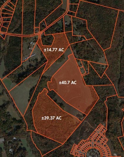
This Property Is For Sale
Property Detail
4440 Davidson Rd
4673-21-4708-0000
SOUTH SIDE NOT ADJ DAVIDSON RD
Residentialacreage
CABARRUS
R8
North Carolina
B and X Area of moderate flood hazard, usually the area between the limits of the 100-year and 500-year floods.
14.77 AC
2025
Cabarrus County
2025
Charlotte
006404
Charlotte-Concord-Gastonia, NC-SC
NEARBY LISTINGS FOR SALE OR LEASE
-
-
View all Davidson listings for sale on LoopNet.com
DEMOGRAPHICS near 4440 Davidson Rd
1 mile
3 mile
5 mile
2025 Total Population
2,890
19,623
65,883
2030 Population
3,110
21,202
71,205
Pop Growth 2025-2030
+ 7.61%
+ 8.05%
+ 8.08%
Average Age
37
37
38
2025 Total Households
924
6,282
22,204
HH Growth 2025-2030
+ 7.79%
+ 8.25%
+ 8.39%
Median Household Inc
$158,654
$154,714
$142,465
Avg Household Size
3.10
3.10
2.90
2025 Avg HH Vehicles
2.00
2.00
2.00
Median Home Value
$657,370
$633,402
$569,029
Median Year Built
2009
2010
2006
Nearby Places
Map Layers
Map Styles
 Street
 Aerial
Transit
 Traffic
 Biking
Places
Listings with unknown addresses are not visible on the map
- Restaurants
- Banks
- Shops
- Fitness
- Groceries
PUBLIC TRANSPORTATION
COMMUTER RAIL
Kannapolis Station (Piedmont - North Carolina by Train (NC Train))
Drive
Walk
Distance
Kannapolis Station (Piedmont - North Carolina by Train (NC Train))
17 min
9.5 mi
AIRPORT
Concord-Padgett Regional
Drive
Walk
Distance
Concord-Padgett Regional
19 min
10.3 mi
Charlotte/Douglas International
Drive
Walk
Distance
Charlotte/Douglas International
47 min
30.2 mi
Freight Ports
Port of Wilmington
Drive
Walk
Distance
Port of Wilmington
272 min
214.0 mi
Nearby Properties
Address
Land Use
TOTAL SIZE
Lot Size
Zoning
Address
Land Use
TOTAL SIZE
Lot Size
Zoning
140,605 SF
33.96 AC
R
Address
Land Use
TOTAL SIZE
Lot Size
Zoning
26,134 SF
98.70 AC
GC
Address
Land Use
TOTAL SIZE
Lot Size
Zoning
77,612 SF
21.10 AC
NE
Address
Land Use
TOTAL SIZE
Lot Size
Zoning
15,900 SF
7.63 AC
GC
Address
Land Use
TOTAL SIZE
Lot Size
Zoning
1,550 SF
239.93 AC
R
Address
Land Use
TOTAL SIZE
Lot Size
Zoning
3,184 SF
200.03 AC
RPA
Address
Land Use
TOTAL SIZE
Lot Size
Zoning
20,467 SF
51.68 AC
C
Address
Land Use
TOTAL SIZE
Lot Size
Zoning
Address
Land Use
TOTAL SIZE
Lot Size
Zoning
32,530 SF
28.24 AC
CD
Address
Land Use
TOTAL SIZE
Lot Size
Zoning
27,416 SF
2.06 AC
GC
Address
Land Use
TOTAL SIZE
Lot Size
Zoning
5.75 AC
Address
Land Use
TOTAL SIZE
Lot Size
Zoning
15,021 SF
1.44 AC
GC
Address
Land Use
TOTAL SIZE
Lot Size
Zoning
2,622 SF
14.57 AC
RA
Address
Land Use
TOTAL SIZE
Lot Size
Zoning
70.31 AC
R
Address
Land Use
TOTAL SIZE
Lot Size
Zoning
17,862 SF
30 AC
R
Address
Land Use
TOTAL SIZE
Lot Size
Zoning
119.14 AC
AO
Address
Land Use
TOTAL SIZE
Lot Size
Zoning
8,010 SF
1.11 AC
GC
Address
Land Use
TOTAL SIZE
Lot Size
Zoning
4,096 SF
1.33 AC
GC
Address
Land Use
TOTAL SIZE
Lot Size
Zoning
6,410 SF
8.90 AC
AO
Address
Land Use
TOTAL SIZE
Lot Size
Zoning
4,377 SF
1.15 AC
GC
Address
Land Use
TOTAL SIZE
Lot Size
Zoning
2.30 AC
GC
Address
Land Use
TOTAL SIZE
Lot Size
Zoning
10,034 SF
15.83 AC
CR
Address
Land Use
TOTAL SIZE
Lot Size
Zoning
1,569 SF
3 AC
GC
Address
Land Use
TOTAL SIZE
Lot Size
Zoning
55.11 AC
RR
Address
Land Use
TOTAL SIZE
Lot Size
Zoning
33.39 AC
R18
Address
Land Use
TOTAL SIZE
Lot Size
Zoning
60.50 AC
R4
Address
Land Use
TOTAL SIZE
Lot Size
Zoning
19.46 AC
CD
Address
Land Use
TOTAL SIZE
Lot Size
Zoning
5,319 SF
10.16 AC
NE
Address
Land Use
TOTAL SIZE
Lot Size
Zoning
7,786 SF
33.74 AC
R
Address
Land Use
TOTAL SIZE
Lot Size
Zoning
14,336 SF
2.33 AC
RPA
The World's #1 Commercial Real Estate Marketplace
Connect with us
© 2026 CoStar Group
The information above has been obtained from sources believed reliable. While we do not doubt its accuracy we have not verified it and make no guarantee, warranty or representation about it. It is your responsibility to independently confirm its accuracy and completeness. Any projections, opinions, assumptions, or estimates used are for example only and do not represent the current or future performance of the property. The value of this transaction to you depends on tax and other factors which should be evaluated by your tax, financial, and legal advisors. You and your advisors should conduct a careful, independent investigation of the property to determine to your satisfaction the suitability of the property for your needs.