Property Record
4441 N Ruby Carson Blvd, Birmingham, AL 35215
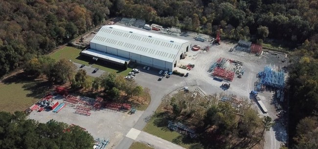

Property Detail
4441 N Ruby Carson Blvd
13-00-11-3-000-003.002
COM SW COR OF SW 1/4 SEC 11 TP 16 R 2W TH E 846.2 FT TO W R/W LINE L & N RR TH NELY ALG R/W 1615.4 FT TO POB TH CONT NELY 645 FT TH NWLY 793.9 FT TH SWLY 650 FT TH SELY 810.3 FT TO POB SECT 11 TWSP 16S RANGE 2W
Warehouse
Jefferson
I4
Alabama
B and X Area of moderate flood hazard, usually the area between the limits of the 100-year and 500-year floods.
12 AC
2024
Fultondale
2025
Birmingham
011803
Birmingham, AL
55,720 SF
NEARBY LISTINGS FOR SALE OR LEASE
DEMOGRAPHICS near 4441 N Ruby Carson Blvd
1 mile
3 mile
5 mile
2025 Total Population
3,499
29,100
74,645
2030 Population
3,464
28,556
73,202
Pop Growth 2025-2030
(1.00%)
(1.87%)
(1.93%)
Average Age
37
37
38
2025 Total Households
1,316
10,868
28,199
HH Growth 2025-2030
(1.14%)
(1.92%)
(1.96%)
Median Household Inc
$49,361
$54,724
$58,170
Avg Household Size
2.60
2.60
2.60
2025 Avg HH Vehicles
2.00
2.00
2.00
Median Home Value
$181,892
$167,036
$175,432
Median Year Built
1976
1975
1975
Nearby Places
Map Layers
Map Styles
 Street
 Aerial
Layers
 Traffic
 Biking
Places
Listings with unknown addresses are not visible on the map
- Restaurants
- Banks
- Shops
- Fitness
- Groceries
PUBLIC TRANSPORTATION
AIRPORT
Birmingham-Shuttlesworth International
Drive
Walk
Distance
Birmingham-Shuttlesworth International
21 min
12.2 mi
Freight Ports
Port of Mobile
Drive
Walk
Distance
Port of Mobile
299 min
268.7 mi
SALE & LEASE HISTORY
LISTING DATE
SALE/LEASE

Nov 20, 2018
For Lease
Nov 20, 2018
For Sale
Nearby Properties
Address
Land Use
TOTAL SIZE
Lot Size
Zoning
Address
Land Use
TOTAL SIZE
Lot Size
Zoning
725,840 SF
89 AC
CM2
Address
Land Use
TOTAL SIZE
Lot Size
Zoning
150,160 SF
12 AC
INST
Address
Land Use
TOTAL SIZE
Lot Size
Zoning
284,402 SF
23 AC
I4
Address
Land Use
TOTAL SIZE
Lot Size
Zoning
623,200 SF
50 AC
CM2
Address
Land Use
TOTAL SIZE
Lot Size
Zoning
218,922 SF
21 AC
CR5
Address
Land Use
TOTAL SIZE
Lot Size
Zoning
412,320 SF
17 AC
I2
Address
Land Use
TOTAL SIZE
Lot Size
Zoning
192,596 SF
14 AC
CR5
Address
Land Use
TOTAL SIZE
Lot Size
Zoning
118,522 SF
8 AC
I4
Address
Land Use
TOTAL SIZE
Lot Size
Zoning
531,808 SF
24 AC
I4&A
Address
Land Use
TOTAL SIZE
Lot Size
Zoning
169,230 SF
22.97 AC
I4
Address
Land Use
TOTAL SIZE
Lot Size
Zoning
502,302 SF
25 AC
I4&A
Address
Land Use
TOTAL SIZE
Lot Size
Zoning
147,200 SF
8 AC
CR5
Address
Land Use
TOTAL SIZE
Lot Size
Zoning
125,252 SF
8.07 AC
R4
Address
Land Use
TOTAL SIZE
Lot Size
Zoning
163,790 SF
18 AC
I-4
Address
Land Use
TOTAL SIZE
Lot Size
Zoning
179,464 SF
18 AC
M3
Address
Land Use
TOTAL SIZE
Lot Size
Zoning
340,000 SF
29 AC
I4
Address
Land Use
TOTAL SIZE
Lot Size
Zoning
26,169 SF
71 AC
R2
Address
Land Use
TOTAL SIZE
Lot Size
Zoning
109,878 SF
10 AC
C1
Address
Land Use
TOTAL SIZE
Lot Size
Zoning
74,159 SF
3 AC
INST
Address
Land Use
TOTAL SIZE
Lot Size
Zoning
84,282 SF
6 AC
R4
Address
Land Use
TOTAL SIZE
Lot Size
Zoning
148,245 SF
9 AC
CR5
Address
Land Use
TOTAL SIZE
Lot Size
Zoning
257,988 SF
CM2
Address
Land Use
TOTAL SIZE
Lot Size
Zoning
84,602 SF
11 AC
B2
Address
Land Use
TOTAL SIZE
Lot Size
Zoning
118,041 SF
5 AC
C1
Address
Land Use
TOTAL SIZE
Lot Size
Zoning
99,917 SF
17 AC
M-3
Address
Land Use
TOTAL SIZE
Lot Size
Zoning
44,912 SF
14.50 AC
I4-U
Address
Land Use
TOTAL SIZE
Lot Size
Zoning
100,788 SF
17 AC
I2
Address
Land Use
TOTAL SIZE
Lot Size
Zoning
113,175 SF
22 AC
I2
Address
Land Use
TOTAL SIZE
Lot Size
Zoning
86,240 SF
104 AC
CM2
The World's #1 Commercial Real Estate Marketplace
Connect with us
© 2026 CoStar Group
The information above has been obtained from sources believed reliable. While we do not doubt its accuracy we have not verified it and make no guarantee, warranty or representation about it. It is your responsibility to independently confirm its accuracy and completeness. Any projections, opinions, assumptions, or estimates used are for example only and do not represent the current or future performance of the property. The value of this transaction to you depends on tax and other factors which should be evaluated by your tax, financial, and legal advisors. You and your advisors should conduct a careful, independent investigation of the property to determine to your satisfaction the suitability of the property for your needs.