Property Record
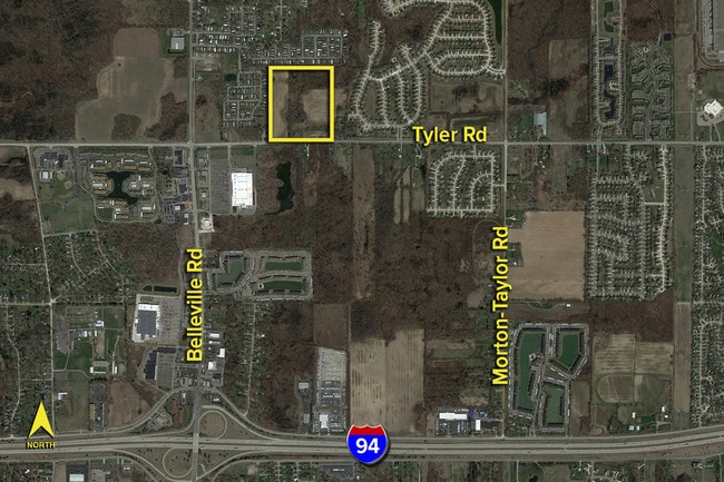
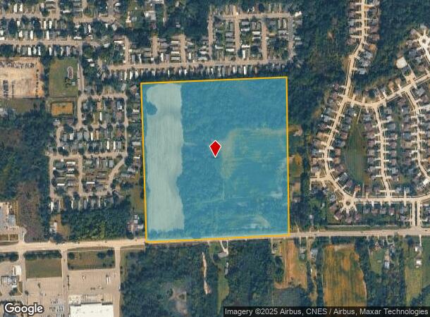
44804 Tyler Rd, Van Buren Township, MI 48111

This Property Is For Sale
NEARBY LISTINGS FOR SALE OR LEASE
Property Detail
44804 Tyler Rd
Detroit-Warren-Dearborn, MI
Walden Woods
83-039-99-0013-000
10U1 THE SE 1/4 OF THE SW 1/4 OF SEC 10 EXC THE EAST 5.00 ACRES THEREOF 35.26 ACRES
Residentialacreage
Wayne
X
Michigan
26163C0351E
0013
2024
34.37 AC
2025
Airport District
587900
Detroit
DEMOGRAPHICS near 44804 Tyler Rd
1 Mile
3 Mile
5 Mile
2024 Total Population
4,966
27,043
89,827
2029 Population
4,733
25,889
86,881
Pop Growth 2024-2029
(4.69%)
(4.27%)
(3.28%)
Average Age
40
40
40
2024 Total Households
2,046
11,860
36,314
HH Growth 2024-2029
(4.74%)
(4.27%)
(3.29%)
Median Household Inc
$83,092
$68,199
$75,848
Avg Household Size
2.40
2.20
2.40
2024 Avg HH Vehicles
2.00
2.00
2.00
Median Home Value
$243,587
$231,290
$241,642
Median Year Built
1994
1980
1985
Nearby Places
- Restaurants
- Banks
- Shops
- Fitness
- Groceries
PUBLIC TRANSPORTATION
AIRPORT
Detroit Metro Wayne County
DRIVE
WALK
Distance
Detroit Metro Wayne County
15 min
10.1 mi
Windsor International
DRIVE
WALK
Distance
Windsor International
56 min
37.4 mi
Freight Ports
Port of Toledo
DRIVE
WALK
Distance
Port of Toledo
65 min
51.7 mi
Nearby Properties
Address
Land Use
TOTAL SIZE
Lot Size
Zoning
Address
Land Use
TOTAL SIZE
Lot Size
Zoning
739,289 SF
238.69 AC
AG
Address
Land Use
TOTAL SIZE
Lot Size
Zoning
347,606 SF
71.56 AC
M2 GEN
Address
Land Use
TOTAL SIZE
Lot Size
Zoning
919,978 SF
65.96 AC
MT IND
Address
Land Use
TOTAL SIZE
Lot Size
Zoning
461,566 SF
50.13 AC
RM MULT
Address
Land Use
TOTAL SIZE
Lot Size
Zoning
495,062 SF
52.40 AC
M1 LIG
Address
Land Use
TOTAL SIZE
Lot Size
Zoning
387,834 SF
71.56 AC
M2 GEN
Address
Land Use
TOTAL SIZE
Lot Size
Zoning
357,286 SF
36.79 AC
RM MULT
Address
Land Use
TOTAL SIZE
Lot Size
Zoning
432.42 AC
M2 GEN
Address
Land Use
TOTAL SIZE
Lot Size
Zoning
1,182 SF
25.21 AC
G-1
Address
Land Use
TOTAL SIZE
Lot Size
Zoning
1,071,200 SF
85.27 AC
M1 LIG
Address
Land Use
TOTAL SIZE
Lot Size
Zoning
182,952 SF
82.77 AC
Address
Land Use
TOTAL SIZE
Lot Size
Zoning
524,171 SF
42.18 AC
M2 GEN
Address
Land Use
TOTAL SIZE
Lot Size
Zoning
685,104 SF
44.25 AC
M1 LIG
Address
Land Use
TOTAL SIZE
Lot Size
Zoning
136,775 SF
15.54 AC
C-3
Address
Land Use
TOTAL SIZE
Lot Size
Zoning
450,840 SF
32.59 AC
Address
Land Use
TOTAL SIZE
Lot Size
Zoning
443,082 SF
30.01 AC
LI-2
Address
Land Use
TOTAL SIZE
Lot Size
Zoning
206,958 SF
8.33 AC
AP
Address
Land Use
TOTAL SIZE
Lot Size
Zoning
198,549 SF
13.43 AC
RM MULT
Address
Land Use
TOTAL SIZE
Lot Size
Zoning
630,828 SF
62.51 AC
R1B
Address
Land Use
TOTAL SIZE
Lot Size
Zoning
630,828 SF
62.51 AC
R1B
Address
Land Use
TOTAL SIZE
Lot Size
Zoning
196,044 SF
18.67 AC
RM MULT
Address
Land Use
TOTAL SIZE
Lot Size
Zoning
659,516 SF
46.15 AC
MT IND
Address
Land Use
TOTAL SIZE
Lot Size
Zoning
437,836 SF
28.75 AC
M1 LIG
Address
Land Use
TOTAL SIZE
Lot Size
Zoning
161,794 SF
17.73 AC
RM MULT
Address
Land Use
TOTAL SIZE
Lot Size
Zoning
949,540 SF
75.26 AC
M2 GEN
Address
Land Use
TOTAL SIZE
Lot Size
Zoning
132,528 SF
5.91 AC
C2 EXT
Address
Land Use
TOTAL SIZE
Lot Size
Zoning
399,840 SF
28.40 AC
M1 LIG
Address
Land Use
TOTAL SIZE
Lot Size
Zoning
25,002 SF
7.91 AC
C1 GEN
Address
Land Use
TOTAL SIZE
Lot Size
Zoning
199,776 SF
39.34 AC
C2 EXT
Address
Land Use
TOTAL SIZE
Lot Size
Zoning
137,893 SF
16.21 AC
C2 EXT
The World's #1 Commercial Real Estate Marketplace
Connect with us
© 2025 CoStar Group
The information above has been obtained from sources believed reliable. While we do not doubt its accuracy we have not verified it and make no guarantee, warranty or representation about it. It is your responsibility to independently confirm its accuracy and completeness. Any projections, opinions, assumptions, or estimates used are for example only and do not represent the current or future performance of the property. The value of this transaction to you depends on tax and other factors which should be evaluated by your tax, financial, and legal advisors. You and your advisors should conduct a careful, independent investigation of the property to determine to your satisfaction the suitability of the property for your needs.