Property Record
4444 Branch Ave, Temple Hills, MD 20748
NEARBY LISTINGS FOR SALE OR LEASE
-
-
-
-
-
4719 Stamp Road, Temple Hills, MD 20748
Temple Hills, MD 20748
$22.00 SF/YR
1,000 - 2,600 SF
Industrial
-
-
-
View all Temple Hills listings for sale on LoopNet.com
Property Detail
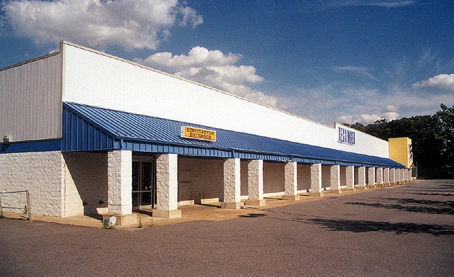
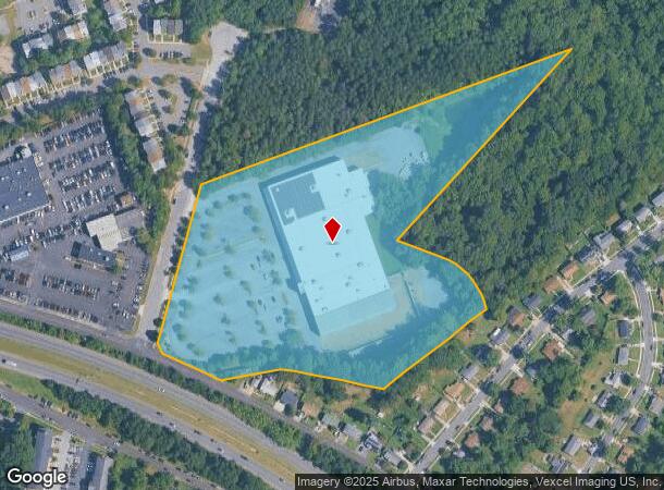
4444 Branch Ave
Washington-Arlington-Alexandria, DC-VA-MD-WV
Hechinger Merlow Heights
06-2753622
PARCEL A
Storebuilding
Prince George's
X
Maryland
24033C0235E
a
2024
12.18 AC
2025
Branch Ave Corridor
802001
Washington, DC
92,996 SF
DEMOGRAPHICS near 4444 Branch Ave
1 Mile
3 Mile
5 Mile
2024 Total Population
9,784
138,565
362,990
2029 Population
9,566
133,497
344,907
Pop Growth 2024-2029
(2.23%)
(3.66%)
(4.98%)
Average Age
40
40
39
2024 Total Households
4,497
56,886
144,395
HH Growth 2024-2029
(2.33%)
(3.88%)
(5.53%)
Median Household Inc
$60,509
$67,004
$65,804
Avg Household Size
2.10
2.40
2.40
2024 Avg HH Vehicles
1.00
1.00
1.00
Median Home Value
$268,814
$311,586
$344,143
Median Year Built
1974
1967
1966
Nearby Places
Map Layers
Map Styles
 Street
 Aerial
- Restaurants
- Banks
- Shops
- Fitness
- Groceries
PUBLIC TRANSPORTATION
COMMUTER RAIL
Union Station (Red Line - Washington Metropolitan Area Transit Authority Metrorail (Metrorail))
DRIVE
WALK
Distance
Union Station (Red Line - Washington Metropolitan Area Transit Authority Metrorail (Metrorail))
18 min
7.1 mi
DRIVE
WALK
Distance
16 min
7.2 mi
AIRPORT
Ronald Reagan Washington Ntl
DRIVE
WALK
Distance
Ronald Reagan Washington Ntl
23 min
11.3 mi
Baltimore/Washington International Thurgood Marshall
DRIVE
WALK
Distance
Baltimore/Washington International Thurgood Marshall
54 min
34.0 mi
Washington Dulles International
DRIVE
WALK
Distance
Washington Dulles International
61 min
35.6 mi
Freight Ports
Port of Baltimore
DRIVE
WALK
Distance
Port of Baltimore
62 min
40.3 mi
Nearby Properties
Address
Land Use
TOTAL SIZE
Lot Size
Zoning
Address
Land Use
TOTAL SIZE
Lot Size
Zoning
2,131,229 SF
144.34 AC
AG
Address
Land Use
TOTAL SIZE
Lot Size
Zoning
963,250 SF
10.71 AC
RTOLE
Address
Land Use
TOTAL SIZE
Lot Size
Zoning
417 SF
7.66 AC
RTOLE
Address
Land Use
TOTAL SIZE
Lot Size
Zoning
26.64 AC
RMF20
Address
Land Use
TOTAL SIZE
Lot Size
Zoning
450 SF
20.72 AC
RMF20
Address
Land Use
TOTAL SIZE
Lot Size
Zoning
6 AC
RTOLE
Address
Land Use
TOTAL SIZE
Lot Size
Zoning
473,030 SF
3.08 AC
RA-1
Address
Land Use
TOTAL SIZE
Lot Size
Zoning
111.87 AC
IE
Address
Land Use
TOTAL SIZE
Lot Size
Zoning
98.14 AC
IE
Address
Land Use
TOTAL SIZE
Lot Size
Zoning
29.24 AC
RMF20
Address
Land Use
TOTAL SIZE
Lot Size
Zoning
73.26 AC
IE
Address
Land Use
TOTAL SIZE
Lot Size
Zoning
45.36 AC
MU-1;RA-1
Address
Land Use
TOTAL SIZE
Lot Size
Zoning
262 SF
24.86 AC
RMF20
Address
Land Use
TOTAL SIZE
Lot Size
Zoning
701 SF
29.42 AC
RMF20
Address
Land Use
TOTAL SIZE
Lot Size
Zoning
450 SF
21.14 AC
RMF20
Address
Land Use
TOTAL SIZE
Lot Size
Zoning
40.63 AC
RA-1
Address
Land Use
TOTAL SIZE
Lot Size
Zoning
13.21 AC
RMF48
Address
Land Use
TOTAL SIZE
Lot Size
Zoning
29.49 AC
RSFA
Address
Land Use
TOTAL SIZE
Lot Size
Zoning
17.90 AC
RMF20
Address
Land Use
TOTAL SIZE
Lot Size
Zoning
21.48 AC
RMF20
Address
Land Use
TOTAL SIZE
Lot Size
Zoning
22.67 AC
RMF20
Address
Land Use
TOTAL SIZE
Lot Size
Zoning
383,961 SF
2.90 AC
MU-7B
Address
Land Use
TOTAL SIZE
Lot Size
Zoning
17.08 AC
RMF20
Address
Land Use
TOTAL SIZE
Lot Size
Zoning
245,767 SF
13.88 AC
CGO
Address
Land Use
TOTAL SIZE
Lot Size
Zoning
132,628 SF
10.67 AC
MU-1;RA-1
Address
Land Use
TOTAL SIZE
Lot Size
Zoning
303,288 SF
16.04 AC
RMF20
Address
Land Use
TOTAL SIZE
Lot Size
Zoning
11.82 AC
RMF20
Address
Land Use
TOTAL SIZE
Lot Size
Zoning
15.65 AC
RMF20
Address
Land Use
TOTAL SIZE
Lot Size
Zoning
238,785 SF
12.79 AC
CGO
Address
Land Use
TOTAL SIZE
Lot Size
Zoning
26.64 AC
RA-1
The World's #1 Commercial Real Estate Marketplace
Connect with us
© 2025 CoStar Group
The information above has been obtained from sources believed reliable. While we do not doubt its accuracy we have not verified it and make no guarantee, warranty or representation about it. It is your responsibility to independently confirm its accuracy and completeness. Any projections, opinions, assumptions, or estimates used are for example only and do not represent the current or future performance of the property. The value of this transaction to you depends on tax and other factors which should be evaluated by your tax, financial, and legal advisors. You and your advisors should conduct a careful, independent investigation of the property to determine to your satisfaction the suitability of the property for your needs.