Property Record
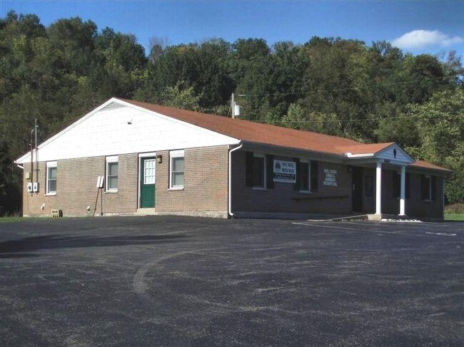
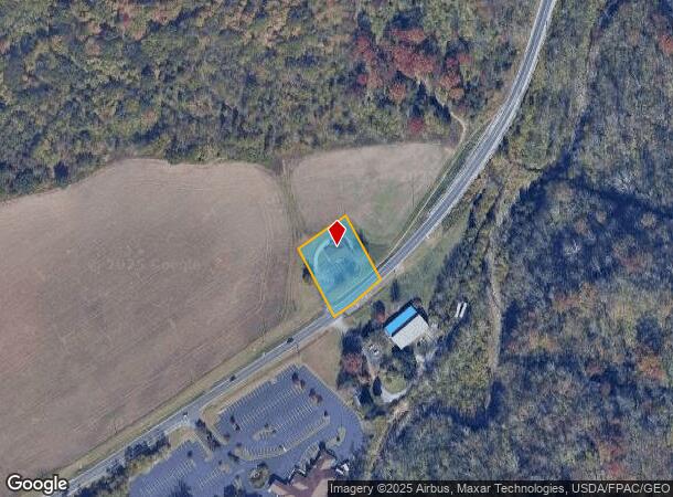
4447 State Route 132, Batavia, OH 45103
NEARBY LISTINGS FOR SALE OR LEASE
Property Detail
4447 State Route 132
01-20-03I-064
Hillside Animal Hospital
Officebuilding
HILLSIDE ANIMAL HOSPITAL
X
Clermont
39025C0233G
Ohio
2024
0.75 AC
2024
Outlying Cincinnati East
041002
Cincinnati/Dayton
2,400 SF
Cincinnati, OH-KY-IN
DEMOGRAPHICS near 4447 State Route 132
1 mile
3 mile
5 mile
2024 Total Population
2,255
13,103
50,054
2029 Population
2,311
13,520
51,548
Pop Growth 2024-2029
+ 2.48%
+ 3.18%
+ 2.98%
Average Age
41
41
40
2024 Total Households
814
5,012
19,550
HH Growth 2024-2029
+ 2.70%
+ 3.23%
+ 3.10%
Median Household Inc
$79,615
$69,689
$66,498
Avg Household Size
2.60
2.50
2.50
2024 Avg HH Vehicles
2.00
2.00
2.00
Median Home Value
$243,007
$255,629
$223,813
Median Year Built
1983
1992
1990
Nearby Places
Map Layers
Map Styles
 Street
 Aerial
Transit
 Traffic
 Biking
Places
Listings with unknown addresses are not visible on the map
- Restaurants
- Banks
- Shops
- Fitness
- Groceries
PUBLIC TRANSPORTATION
AIRPORT
Cincinnati/Northern Kentucky International
Drive
Walk
Distance
Cincinnati/Northern Kentucky International
48 min
32.6 mi
SALE & LEASE HISTORY
LISTING DATE
SALE/LEASE

Sep 25, 2016
For Lease
Oct 21, 2016
For Sale
Nearby Properties
Address
Land Use
TOTAL SIZE
Lot Size
Zoning
Address
Land Use
TOTAL SIZE
Lot Size
Zoning
58.36 AC
Address
Land Use
TOTAL SIZE
Lot Size
Zoning
11,636 SF
49.40 AC
Address
Land Use
TOTAL SIZE
Lot Size
Zoning
11,215 SF
20.57 AC
Address
Land Use
TOTAL SIZE
Lot Size
Zoning
20,468 SF
143.20 AC
Address
Land Use
TOTAL SIZE
Lot Size
Zoning
Address
Land Use
TOTAL SIZE
Lot Size
Zoning
11,566 SF
28.70 AC
Address
Land Use
TOTAL SIZE
Lot Size
Zoning
26,263 SF
49.43 AC
Address
Land Use
TOTAL SIZE
Lot Size
Zoning
115,094 SF
18.53 AC
Address
Land Use
TOTAL SIZE
Lot Size
Zoning
17,253 SF
10.59 AC
Address
Land Use
TOTAL SIZE
Lot Size
Zoning
Address
Land Use
TOTAL SIZE
Lot Size
Zoning
9,504 SF
24.04 AC
Address
Land Use
TOTAL SIZE
Lot Size
Zoning
30,540 SF
20.57 AC
Address
Land Use
TOTAL SIZE
Lot Size
Zoning
35,046 SF
0.76 AC
Address
Land Use
TOTAL SIZE
Lot Size
Zoning
2,688 SF
16.09 AC
Address
Land Use
TOTAL SIZE
Lot Size
Zoning
20,482 SF
39.58 AC
Address
Land Use
TOTAL SIZE
Lot Size
Zoning
8,144 SF
41.50 AC
Address
Land Use
TOTAL SIZE
Lot Size
Zoning
5,712 SF
10.76 AC
Address
Land Use
TOTAL SIZE
Lot Size
Zoning
4,812 SF
14.08 AC
Address
Land Use
TOTAL SIZE
Lot Size
Zoning
158,700 SF
31.20 AC
Address
Land Use
TOTAL SIZE
Lot Size
Zoning
5,712 SF
10.76 AC
Address
Land Use
TOTAL SIZE
Lot Size
Zoning
80,311 SF
7.38 AC
Address
Land Use
TOTAL SIZE
Lot Size
Zoning
11.05 AC
Address
Land Use
TOTAL SIZE
Lot Size
Zoning
23,636 SF
4.46 AC
Address
Land Use
TOTAL SIZE
Lot Size
Zoning
81,672 SF
10.57 AC
Address
Land Use
TOTAL SIZE
Lot Size
Zoning
13,272 SF
1.06 AC
Address
Land Use
TOTAL SIZE
Lot Size
Zoning
4,446 SF
4.29 AC
Address
Land Use
TOTAL SIZE
Lot Size
Zoning
61,050 SF
5.09 AC
Address
Land Use
TOTAL SIZE
Lot Size
Zoning
15,800 SF
16.75 AC
Address
Land Use
TOTAL SIZE
Lot Size
Zoning
14,700 SF
68.88 AC
Address
Land Use
TOTAL SIZE
Lot Size
Zoning
16,734 SF
20.01 AC
The World's #1 Commercial Real Estate Marketplace
Connect with us
© 2026 CoStar Group
The information above has been obtained from sources believed reliable. While we do not doubt its accuracy we have not verified it and make no guarantee, warranty or representation about it. It is your responsibility to independently confirm its accuracy and completeness. Any projections, opinions, assumptions, or estimates used are for example only and do not represent the current or future performance of the property. The value of this transaction to you depends on tax and other factors which should be evaluated by your tax, financial, and legal advisors. You and your advisors should conduct a careful, independent investigation of the property to determine to your satisfaction the suitability of the property for your needs.