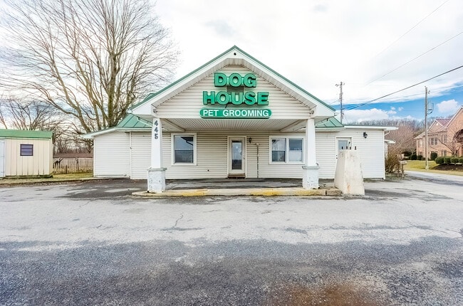
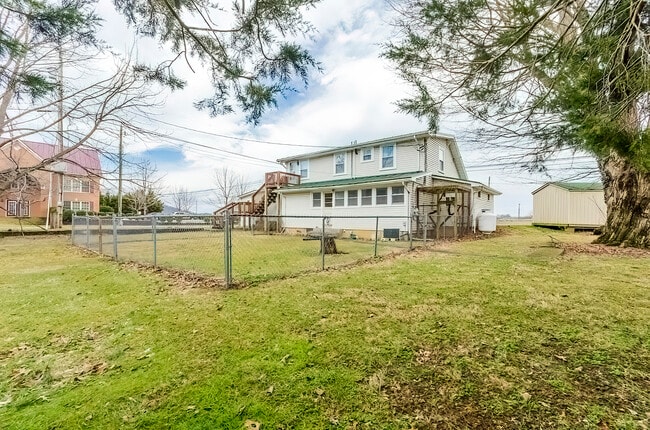
Property Record
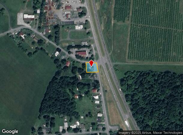
445 Bryarly Rd, Winchester, VA 22603
NEARBY LISTINGS FOR SALE OR LEASE
-
-
View all Winchester listings for sale on LoopNet.com
Property Detail
445 Bryarly Rd
42A-82
2
Multipleuses
.25 ACRE
X
Frederick
51069C0205E
Virginia
2025
0.25 AC
2025
Frederick County
050500
Washington, DC
2,131 SF
Winchester, VA-WV
DEMOGRAPHICS near 445 Bryarly Rd
1 Mile
3 Mile
5 Mile
2024 Total Population
678
10,543
45,012
2029 Population
751
11,251
46,733
Pop Growth 2024-2029
+ 10.77%
+ 6.72%
+ 3.82%
Average Age
52
46
41
2024 Total Households
309
4,360
17,683
HH Growth 2024-2029
+ 10.68%
+ 6.54%
+ 3.57%
Median Household Inc
$90,530
$84,518
$67,617
Avg Household Size
2.10
2.30
2.40
2024 Avg HH Vehicles
2.00
2.00
2.00
Median Home Value
$315,151
$348,554
$307,398
Median Year Built
2010
1985
1980
Nearby Places
Map Layers
Map Styles
 Street
 Aerial
- Restaurants
- Banks
- Shops
- Fitness
- Groceries
SALE & LEASE HISTORY
LISTING DATE
SALE/LEASE

Apr 11, 2021
For Sale
Nearby Properties
Address
Land Use
TOTAL SIZE
Lot Size
Zoning
Address
Land Use
TOTAL SIZE
Lot Size
Zoning
979,509 SF
161.49 AC
MC
Address
Land Use
TOTAL SIZE
Lot Size
Zoning
90,399 SF
131.06 AC
MS
Address
Land Use
TOTAL SIZE
Lot Size
Zoning
10,821 SF
68.86 AC
RA
Address
Land Use
TOTAL SIZE
Lot Size
Zoning
400,400 SF
27.18 AC
M1
Address
Land Use
TOTAL SIZE
Lot Size
Zoning
33,264 SF
10.59 AC
MR
Address
Land Use
TOTAL SIZE
Lot Size
Zoning
300,000 SF
29.04 AC
M1
Address
Land Use
TOTAL SIZE
Lot Size
Zoning
5,293 SF
195.07 AC
LR
Address
Land Use
TOTAL SIZE
Lot Size
Zoning
96,721 SF
9.19 AC
EIP
Address
Land Use
TOTAL SIZE
Lot Size
Zoning
20,844 SF
11.58 AC
RP
Address
Land Use
TOTAL SIZE
Lot Size
Zoning
199,053 SF
20.53 AC
B2
Address
Land Use
TOTAL SIZE
Lot Size
Zoning
151,000 SF
26.91 AC
LR
Address
Land Use
TOTAL SIZE
Lot Size
Zoning
73,226 SF
10.24 AC
B2
Address
Land Use
TOTAL SIZE
Lot Size
Zoning
69,975 SF
14.77 AC
B2
Address
Land Use
TOTAL SIZE
Lot Size
Zoning
74,336 SF
8.91 AC
MC
Address
Land Use
TOTAL SIZE
Lot Size
Zoning
31,134 SF
7.53 AC
MR
Address
Land Use
TOTAL SIZE
Lot Size
Zoning
75,734 SF
10 AC
RA
Address
Land Use
TOTAL SIZE
Lot Size
Zoning
90,000 SF
14.12 AC
M1
Address
Land Use
TOTAL SIZE
Lot Size
Zoning
20,797 SF
9.36 AC
LR
Address
Land Use
TOTAL SIZE
Lot Size
Zoning
159,000 SF
9.44 AC
M1
Address
Land Use
TOTAL SIZE
Lot Size
Zoning
128,000 SF
9.44 AC
M1
Address
Land Use
TOTAL SIZE
Lot Size
Zoning
67.67 AC
M1
Address
Land Use
TOTAL SIZE
Lot Size
Zoning
225,590 SF
15 AC
M1
Address
Land Use
TOTAL SIZE
Lot Size
Zoning
53,316 SF
11.96 AC
M1
Address
Land Use
TOTAL SIZE
Lot Size
Zoning
13,589 SF
16.15 AC
LR
Address
Land Use
TOTAL SIZE
Lot Size
Zoning
60,399 SF
4.09 AC
B2
Address
Land Use
TOTAL SIZE
Lot Size
Zoning
84,500 SF
3.69 AC
B2
Address
Land Use
TOTAL SIZE
Lot Size
Zoning
2,528 SF
18.52 AC
RP
Address
Land Use
TOTAL SIZE
Lot Size
Zoning
216,470 SF
39.75 AC
M1
Address
Land Use
TOTAL SIZE
Lot Size
Zoning
21,716 SF
3 AC
B2
Address
Land Use
TOTAL SIZE
Lot Size
Zoning
38,614 SF
50 AC
RA
The World's #1 Commercial Real Estate Marketplace
Connect with us
© 2026 CoStar Group
The information above has been obtained from sources believed reliable. While we do not doubt its accuracy we have not verified it and make no guarantee, warranty or representation about it. It is your responsibility to independently confirm its accuracy and completeness. Any projections, opinions, assumptions, or estimates used are for example only and do not represent the current or future performance of the property. The value of this transaction to you depends on tax and other factors which should be evaluated by your tax, financial, and legal advisors. You and your advisors should conduct a careful, independent investigation of the property to determine to your satisfaction the suitability of the property for your needs.