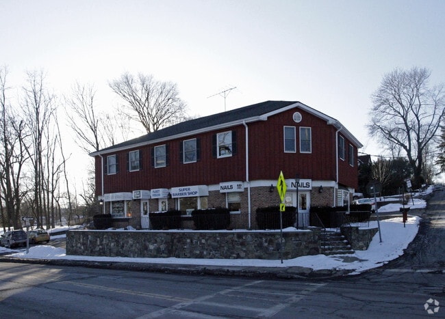
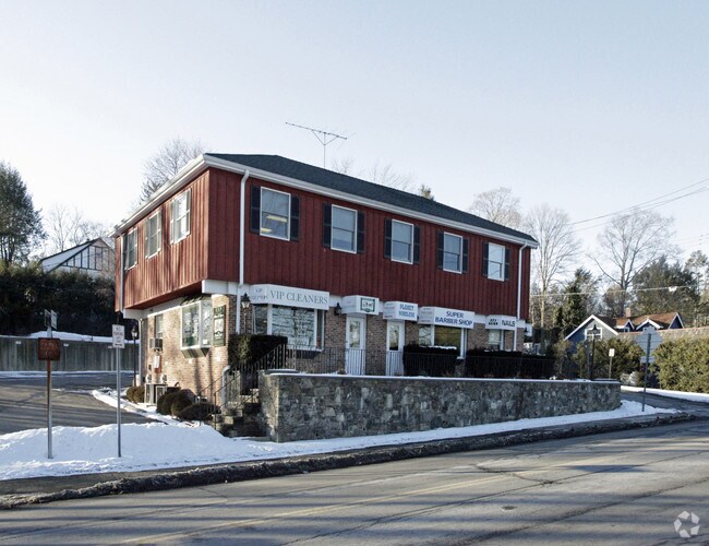
Property Record
445 Main St, Armonk, NY 10504

NEARBY LISTINGS FOR SALE OR LEASE
Property Detail
445 Main St
3800-108-000-00001-000-0006-057-0000
Westchester
Commercialbuilding
New York
X
57.000
36119C0164F
0.27 AC
2025
Northeast
2024
Westchester/So Connecticut
012303
New York-Jersey City-White Plains, NY-NJ
DEMOGRAPHICS near 445 Main St
1 Mile
3 Mile
5 Mile
2024 Total Population
3,257
15,431
57,728
2029 Population
3,216
15,184
56,576
Pop Growth 2024-2029
(1.26%)
(1.60%)
(2.00%)
Average Age
43
42
41
2024 Total Households
1,117
5,003
18,725
HH Growth 2024-2029
(1.34%)
(1.74%)
(2.25%)
Median Household Inc
$218,078
$213,251
$197,627
Avg Household Size
2.80
3.00
2.90
2024 Avg HH Vehicles
2.00
2.00
2.00
Median Home Value
$940,140
$944,668
$845,984
Median Year Built
1983
1968
1962
Nearby Places
Map Layers
Map Styles
 Street
 Aerial
- Restaurants
- Banks
- Shops
- Fitness
- Groceries
PUBLIC TRANSPORTATION
COMMUTER RAIL
Chappaqua Station (Harlem Line - Metro-North Commuter Railroad Company (Metro-North))
DRIVE
WALK
Distance
Chappaqua Station (Harlem Line - Metro-North Commuter Railroad Company (Metro-North))
12 min
6.4 mi
Pleasantville Station (Harlem Line - Metro-North Commuter Railroad Company (Metro-North))
DRIVE
WALK
Distance
Pleasantville Station (Harlem Line - Metro-North Commuter Railroad Company (Metro-North))
14 min
6.6 mi
AIRPORT
Westchester County
DRIVE
WALK
Distance
Westchester County
9 min
5.2 mi
LaGuardia
DRIVE
WALK
Distance
LaGuardia
50 min
32.4 mi
Freight Ports
NY - Red Hook Container Terminal
DRIVE
WALK
Distance
NY - Red Hook Container Terminal
65 min
42.8 mi
SALE & LEASE HISTORY
LISTING DATE
SALE/LEASE

Sep 27, 2017
For Lease
Sep 25, 2016
For Lease
May 19, 2017
For Lease
Nearby Properties
Address
Land Use
TOTAL SIZE
Lot Size
Zoning
Address
Land Use
TOTAL SIZE
Lot Size
Zoning
5,075 SF
169.63 AC
RA-4
Address
Land Use
TOTAL SIZE
Lot Size
Zoning
22.39 AC
RA-4
Address
Land Use
TOTAL SIZE
Lot Size
Zoning
273 AC
RA-4
Address
Land Use
TOTAL SIZE
Lot Size
Zoning
12,368 SF
8.04 AC
RA-4
Address
Land Use
TOTAL SIZE
Lot Size
Zoning
37.43 AC
RA-4
Address
Land Use
TOTAL SIZE
Lot Size
Zoning
10.89 AC
RA-4
Address
Land Use
TOTAL SIZE
Lot Size
Zoning
228.85 AC
OB
Address
Land Use
TOTAL SIZE
Lot Size
Zoning
5.46 AC
RA-4
Address
Land Use
TOTAL SIZE
Lot Size
Zoning
6.47 AC
RA-4
Address
Land Use
TOTAL SIZE
Lot Size
Zoning
18.50 AC
RA-4
Address
Land Use
TOTAL SIZE
Lot Size
Zoning
8.05 AC
RA-4
Address
Land Use
TOTAL SIZE
Lot Size
Zoning
5,631 SF
5.36 AC
RA-4
Address
Land Use
TOTAL SIZE
Lot Size
Zoning
4.44 AC
RA-4
Address
Land Use
TOTAL SIZE
Lot Size
Zoning
7.91 AC
RA-4
Address
Land Use
TOTAL SIZE
Lot Size
Zoning
4.31 AC
RA-4
Address
Land Use
TOTAL SIZE
Lot Size
Zoning
67.98 AC
BEX-50
Address
Land Use
TOTAL SIZE
Lot Size
Zoning
66.22 AC
R-2A
Address
Land Use
TOTAL SIZE
Lot Size
Zoning
4.01 AC
RA-4
Address
Land Use
TOTAL SIZE
Lot Size
Zoning
5.61 AC
RA-4
Address
Land Use
TOTAL SIZE
Lot Size
Zoning
2.60 AC
RA-4
Address
Land Use
TOTAL SIZE
Lot Size
Zoning
6.87 AC
Address
Land Use
TOTAL SIZE
Lot Size
Zoning
6.43 AC
RA-4
Address
Land Use
TOTAL SIZE
Lot Size
Zoning
32.56 AC
RA-4
Address
Land Use
TOTAL SIZE
Lot Size
Zoning
5 AC
RA-4
Address
Land Use
TOTAL SIZE
Lot Size
Zoning
12.65 AC
RA-4
Address
Land Use
TOTAL SIZE
Lot Size
Zoning
8.21 AC
RA-4
Address
Land Use
TOTAL SIZE
Lot Size
Zoning
8.08 AC
RA-4
Address
Land Use
TOTAL SIZE
Lot Size
Zoning
7,502 SF
0.98 AC
RA-4
Address
Land Use
TOTAL SIZE
Lot Size
Zoning
12.34 AC
R-1A
Address
Land Use
TOTAL SIZE
Lot Size
Zoning
4,648 SF
8 AC
RA-4
The World's #1 Commercial Real Estate Marketplace
Connect with us
© 2026 CoStar Group
The information above has been obtained from sources believed reliable. While we do not doubt its accuracy we have not verified it and make no guarantee, warranty or representation about it. It is your responsibility to independently confirm its accuracy and completeness. Any projections, opinions, assumptions, or estimates used are for example only and do not represent the current or future performance of the property. The value of this transaction to you depends on tax and other factors which should be evaluated by your tax, financial, and legal advisors. You and your advisors should conduct a careful, independent investigation of the property to determine to your satisfaction the suitability of the property for your needs.