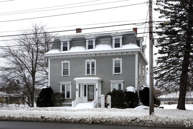
Property Record
445 Main St, Saco, ME 04072

Property Detail
445 Main St
SACO-000033-000025
York
Officebuilding
Maine
MDR
25
B and X Area of moderate flood hazard, usually the area between the limits of the 100-year and 500-year floods.
0.28 AC
2025
York County
2025
Portland/South Portland
005200
Portland-South Portland, ME
3,921 SF
NEARBY LISTINGS FOR SALE OR LEASE
-
-
View all Saco listings for lease on LoopNet.com
DEMOGRAPHICS near 445 Main St
1 mile
3 mile
5 mile
2025 Total Population
8,035
40,032
53,812
2030 Population
8,154
40,892
55,376
Pop Growth 2025-2030
+ 1.48%
+ 2.15%
+ 2.91%
Average Age
42
44
44
2025 Total Households
3,656
18,227
24,078
HH Growth 2025-2030
+ 1.39%
+ 2.21%
+ 3.10%
Median Household Inc
$70,214
$72,310
$77,676
Avg Household Size
2.10
2.10
2.10
2025 Avg HH Vehicles
2.00
2.00
2.00
Median Home Value
$357,338
$389,351
$418,003
Median Year Built
1973
1972
1976
Nearby Places
Map Layers
Map Styles
 Street
 Aerial
Layers
 Traffic
 Biking
Places
Listings with unknown addresses are not visible on the map
- Restaurants
- Banks
- Shops
- Fitness
- Groceries
PUBLIC TRANSPORTATION
COMMUTER RAIL
Saco Amtrak Station (Downeaster - Amtrak)
Drive
Walk
Distance
Saco Amtrak Station (Downeaster - Amtrak)
2 min
17 min
0.9 mi
AIRPORT
Portland International Jetport
Drive
Walk
Distance
Portland International Jetport
20 min
14.0 mi
Freight Ports
Portland, ME
Drive
Walk
Distance
Portland, ME
21 min
16.6 mi
SALE & LEASE HISTORY
LISTING DATE
SALE/LEASE

Oct 08, 2025
For Lease
Jan 04, 2018
For Sale
Feb 21, 2025
For Sale
Aug 20, 2018
For Lease
Nearby Properties
Address
Land Use
TOTAL SIZE
Lot Size
Zoning
Address
Land Use
TOTAL SIZE
Lot Size
Zoning
10 AC
SI
Address
Land Use
TOTAL SIZE
Lot Size
Zoning
233,280 SF
8.40 AC
MSRD3
Address
Land Use
TOTAL SIZE
Lot Size
Zoning
141.52 AC
I
Address
Land Use
TOTAL SIZE
Lot Size
Zoning
230,822 SF
3.50 AC
MSRD3
Address
Land Use
TOTAL SIZE
Lot Size
Zoning
8.47 AC
R1B
Address
Land Use
TOTAL SIZE
Lot Size
Zoning
27.50 AC
MDR
Address
Land Use
TOTAL SIZE
Lot Size
Zoning
69,442 SF
1.12 AC
B2
Address
Land Use
TOTAL SIZE
Lot Size
Zoning
181,148 SF
5.07 AC
SI
Address
Land Use
TOTAL SIZE
Lot Size
Zoning
Address
Land Use
TOTAL SIZE
Lot Size
Zoning
110 AC
WR
Address
Land Use
TOTAL SIZE
Lot Size
Zoning
Address
Land Use
TOTAL SIZE
Lot Size
Zoning
91,642 SF
21.43 AC
R1A
Address
Land Use
TOTAL SIZE
Lot Size
Zoning
124,820 SF
30.53 AC
PR
Address
Land Use
TOTAL SIZE
Lot Size
Zoning
7.86 AC
B2A
Address
Land Use
TOTAL SIZE
Lot Size
Zoning
136,348 SF
1.57 AC
MSRD3
Address
Land Use
TOTAL SIZE
Lot Size
Zoning
48,887 SF
12.59 AC
I
Address
Land Use
TOTAL SIZE
Lot Size
Zoning
2,637 SF
81.33 AC
MZ
Address
Land Use
TOTAL SIZE
Lot Size
Zoning
Address
Land Use
TOTAL SIZE
Lot Size
Zoning
2.50 AC
R-1
Address
Land Use
TOTAL SIZE
Lot Size
Zoning
11.40 AC
GB
Address
Land Use
TOTAL SIZE
Lot Size
Zoning
Address
Land Use
TOTAL SIZE
Lot Size
Zoning
81,369 SF
6.27 AC
PR
Address
Land Use
TOTAL SIZE
Lot Size
Zoning
127,412 SF
12.55 AC
I
Address
Land Use
TOTAL SIZE
Lot Size
Zoning
80,064 SF
9.80 AC
MDR
Address
Land Use
TOTAL SIZE
Lot Size
Zoning
72,508 SF
2.57 AC
MSRD3
Address
Land Use
TOTAL SIZE
Lot Size
Zoning
65,494 SF
2.61 AC
LDR
Address
Land Use
TOTAL SIZE
Lot Size
Zoning
104.71 AC
PR
Address
Land Use
TOTAL SIZE
Lot Size
Zoning
708 SF
52.01 AC
R-4
Address
Land Use
TOTAL SIZE
Lot Size
Zoning
52,263 SF
5.60 AC
LDR
Address
Land Use
TOTAL SIZE
Lot Size
Zoning
4.49 AC
HB
The World's #1 Commercial Real Estate Marketplace
Connect with us
© 2026 CoStar Group
The information above has been obtained from sources believed reliable. While we do not doubt its accuracy we have not verified it and make no guarantee, warranty or representation about it. It is your responsibility to independently confirm its accuracy and completeness. Any projections, opinions, assumptions, or estimates used are for example only and do not represent the current or future performance of the property. The value of this transaction to you depends on tax and other factors which should be evaluated by your tax, financial, and legal advisors. You and your advisors should conduct a careful, independent investigation of the property to determine to your satisfaction the suitability of the property for your needs.