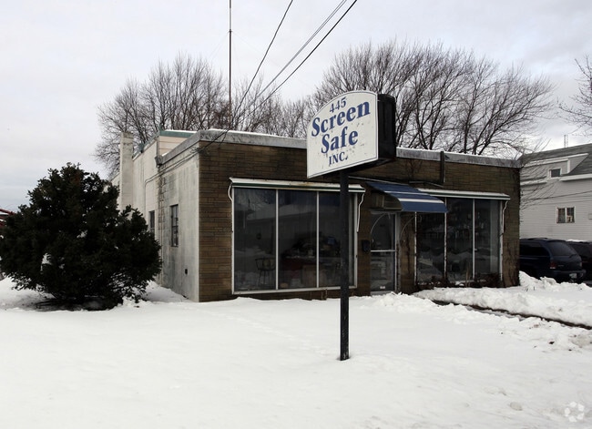
Property Record
445 Niantic Ave, Cranston, RI 02910

Property Detail
445 Niantic Ave
CRAN-000006-000004-001281
Providence
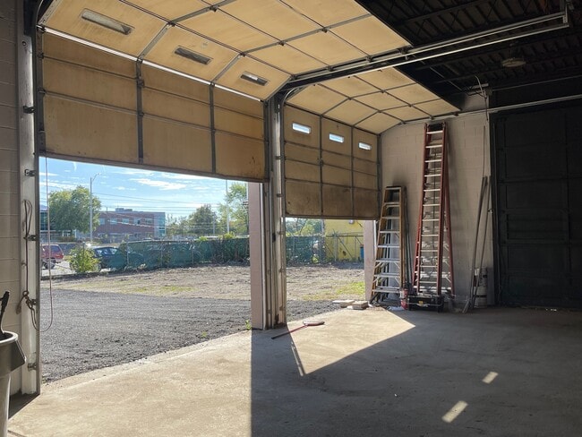
Industrialgeneral
Rhode Island
M2
1281
B and X Area of moderate flood hazard, usually the area between the limits of the 100-year and 500-year floods.
0.16 AC
2025
Cranston
2025
Providence
014100
Providence-Warwick, RI-MA
2,122 SF
NEARBY LISTINGS FOR SALE OR LEASE
DEMOGRAPHICS near 445 Niantic Ave
1 mile
3 mile
5 mile
2025 Total Population
23,893
192,538
372,860
2030 Population
24,411
197,200
383,266
Pop Growth 2025-2030
+ 2.17%
+ 2.42%
+ 2.79%
Average Age
39
38
39
2025 Total Households
8,826
73,501
147,449
HH Growth 2025-2030
+ 2.18%
+ 2.73%
+ 2.98%
Median Household Inc
$65,862
$69,015
$74,347
Avg Household Size
2.60
2.40
2.30
2025 Avg HH Vehicles
2.00
1.00
2.00
Median Home Value
$337,611
$349,813
$365,804
Median Year Built
1947
1949
1952
Nearby Places
Map Layers
Map Styles
 Street
 Aerial
Layers
 Traffic
 Biking
Places
Listings with unknown addresses are not visible on the map
- Restaurants
- Banks
- Shops
- Fitness
- Groceries
PUBLIC TRANSPORTATION
COMMUTER RAIL
Providence (Providence/Stoughton Line - Massachusetts Bay Transportation Authority Commuter Rail (Purple Line))
Drive
Walk
Distance
Providence (Providence/Stoughton Line - Massachusetts Bay Transportation Authority Commuter Rail (Purple Line))
6 min
3.7 mi
Tf Green Airport (Providence/Stoughton Line - MBTA)
Drive
Walk
Distance
Tf Green Airport (Providence/Stoughton Line - MBTA)
11 min
5.2 mi
AIRPORT
Rhode Island Tf Green International
Drive
Walk
Distance
Rhode Island Tf Green International
15 min
6.9 mi
Freight Ports
Port of Davisville, RI
Drive
Walk
Distance
Port of Davisville, RI
31 min
18.3 mi
SALE & LEASE HISTORY
LISTING DATE
SALE/LEASE

Sep 23, 2025
For Lease
Jul 28, 2025
For Lease
Nearby Properties
Address
Land Use
TOTAL SIZE
Lot Size
Zoning
Address
Land Use
TOTAL SIZE
Lot Size
Zoning
162,816 SF
16.52 AC
D-1-10
Address
Land Use
TOTAL SIZE
Lot Size
Zoning
8.93 AC
OS
Address
Land Use
TOTAL SIZE
Lot Size
Zoning
45,000 SF
22.22 AC
M2
Address
Land Use
TOTAL SIZE
Lot Size
Zoning
233,468 SF
1.55 AC
I-1-20
Address
Land Use
TOTAL SIZE
Lot Size
Zoning
396,000 SF
0.12 AC
D-1-30
Address
Land Use
TOTAL SIZE
Lot Size
Zoning
244,872 SF
1.25 AC
D-1-12
Address
Land Use
TOTAL SIZE
Lot Size
Zoning
205,551 SF
1.38 AC
C-2
Address
Land Use
TOTAL SIZE
Lot Size
Zoning
314,273 SF
D-1-20
Address
Land Use
TOTAL SIZE
Lot Size
Zoning
2.01 AC
I-2
Address
Land Use
TOTAL SIZE
Lot Size
Zoning
9.06 AC
PS
Address
Land Use
TOTAL SIZE
Lot Size
Zoning
174,352 SF
2.50 AC
I-1-20
Address
Land Use
TOTAL SIZE
Lot Size
Zoning
3.44 AC
D-1-20
Address
Land Use
TOTAL SIZE
Lot Size
Zoning
4.88 AC
I-2
Address
Land Use
TOTAL SIZE
Lot Size
Zoning
149,663 SF
1.90 AC
D-1-10
Address
Land Use
TOTAL SIZE
Lot Size
Zoning
13.40 AC
C3
Address
Land Use
TOTAL SIZE
Lot Size
Zoning
293,736 SF
1.24 AC
D-1-75
Address
Land Use
TOTAL SIZE
Lot Size
Zoning
91.15 AC
PUD
Address
Land Use
TOTAL SIZE
Lot Size
Zoning
Address
Land Use
TOTAL SIZE
Lot Size
Zoning
277,453 SF
1.83 AC
M-MU-9
Address
Land Use
TOTAL SIZE
Lot Size
Zoning
202,461 SF
1.64 AC
D-1-10
Address
Land Use
TOTAL SIZE
Lot Size
Zoning
221,151 SF
2.13 AC
D-1-12
Address
Land Use
TOTAL SIZE
Lot Size
Zoning
218,167 SF
2.74 AC
D-1-20
Address
Land Use
TOTAL SIZE
Lot Size
Zoning
97,097 SF
0.99 AC
D-1-20
Address
Land Use
TOTAL SIZE
Lot Size
Zoning
2.91 AC
I-2
Address
Land Use
TOTAL SIZE
Lot Size
Zoning
394,538 SF
0.94 AC
D-1-30
Address
Land Use
TOTAL SIZE
Lot Size
Zoning
129,144 SF
3.60 AC
PS
Address
Land Use
TOTAL SIZE
Lot Size
Zoning
164,581 SF
5.73 AC
D-1-30
Address
Land Use
TOTAL SIZE
Lot Size
Zoning
219,406 SF
1.03 AC
D-1-12
Address
Land Use
TOTAL SIZE
Lot Size
Zoning
215,664 SF
1.52 AC
D-1-12
Address
Land Use
TOTAL SIZE
Lot Size
Zoning
1.67 AC
I-2
The World's #1 Commercial Real Estate Marketplace
Connect with us
© 2026 CoStar Group
The information above has been obtained from sources believed reliable. While we do not doubt its accuracy we have not verified it and make no guarantee, warranty or representation about it. It is your responsibility to independently confirm its accuracy and completeness. Any projections, opinions, assumptions, or estimates used are for example only and do not represent the current or future performance of the property. The value of this transaction to you depends on tax and other factors which should be evaluated by your tax, financial, and legal advisors. You and your advisors should conduct a careful, independent investigation of the property to determine to your satisfaction the suitability of the property for your needs.