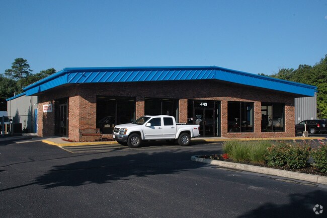
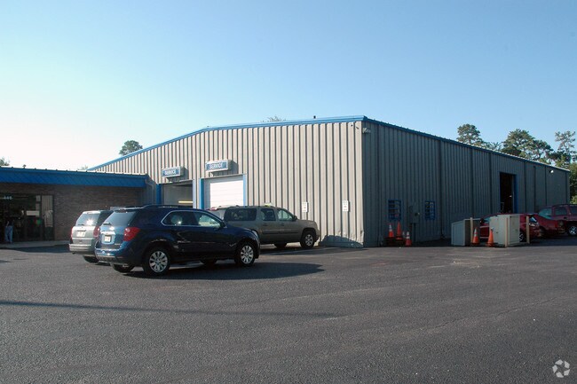
Property Record
445 Route 72 E, Manahawkin, NJ 08050

Save to a Folder
{{folder.Name}}
{{folder.ListingIds.length}} Properties
{{folder.ListingIds.length}} Property
Create a New Folder
Property Detail
445 Route 72 E
31-00147-110-00142
2.861AC
Commercialnec
Ocean
HC
New Jersey
AE The base floodplain where base flood elevations are provided. AE Zones are now used on new format FIRMs instead of A1-A30 Zones.
142
2025
2.86 AC
2026
Ocean County
735106
Northern New Jersey
16,380 SF
Lakewood-New Brunswick, NJ
NEARBY LISTINGS FOR SALE OR LEASE
DEMOGRAPHICS near 445 Route 72 E
1 mile
3 mile
5 mile
2025 Total Population
3,540
17,877
52,099
2030 Population
3,825
19,415
55,639
Pop Growth 2025-2030
+ 8.05%
+ 8.60%
+ 6.79%
Average Age
45
46
43
2025 Total Households
1,493
7,512
20,356
HH Growth 2025-2030
+ 7.77%
+ 8.53%
+ 7.19%
Median Household Inc
$96,773
$110,760
$110,675
Avg Household Size
2.30
2.30
2.50
2025 Avg HH Vehicles
2.00
2.00
2.00
Median Home Value
$446,857
$544,762
$476,739
Median Year Built
1985
1990
1987
Nearby Places
Map Layers
Map Styles
 Street
 Aerial
Layers
 Traffic
 Biking
Places
Listings with unknown addresses are not visible on the map
- Restaurants
- Banks
- Shops
- Fitness
- Groceries
PUBLIC TRANSPORTATION
AIRPORT
Atlantic City International
Drive
Walk
Distance
Atlantic City International
62 min
33.6 mi
Freight Ports
Broadway Terminal - Pier 5
Drive
Walk
Distance
Broadway Terminal - Pier 5
70 min
56.0 mi
Nearby Properties
Address
Land Use
TOTAL SIZE
Lot Size
Zoning
Address
Land Use
TOTAL SIZE
Lot Size
Zoning
91.97 AC
RGL/
Address
Land Use
TOTAL SIZE
Lot Size
Zoning
44.75 AC
MLS/
Address
Land Use
TOTAL SIZE
Lot Size
Zoning
129 AC
PU
Address
Land Use
TOTAL SIZE
Lot Size
Zoning
107,490 SF
30 AC
HC
Address
Land Use
TOTAL SIZE
Lot Size
Zoning
22.43 AC
BP
Address
Land Use
TOTAL SIZE
Lot Size
Zoning
4,232 SF
119.80 AC
R3P/
Address
Land Use
TOTAL SIZE
Lot Size
Zoning
9,920 SF
20.75 AC
HC
Address
Land Use
TOTAL SIZE
Lot Size
Zoning
37.27 AC
RGL/
Address
Land Use
TOTAL SIZE
Lot Size
Zoning
12.04 AC
BP
Address
Land Use
TOTAL SIZE
Lot Size
Zoning
15.71 AC
BP
Address
Land Use
TOTAL SIZE
Lot Size
Zoning
118,850 SF
21.73 AC
HC
Address
Land Use
TOTAL SIZE
Lot Size
Zoning
4,479 SF
18.27 AC
MU
Address
Land Use
TOTAL SIZE
Lot Size
Zoning
15.03 AC
BP
Address
Land Use
TOTAL SIZE
Lot Size
Zoning
9.86 AC
RA4/
Address
Land Use
TOTAL SIZE
Lot Size
Zoning
100,988 SF
7.72 AC
HC
Address
Land Use
TOTAL SIZE
Lot Size
Zoning
101,202 SF
16.10 AC
HC
Address
Land Use
TOTAL SIZE
Lot Size
Zoning
125,352 SF
12.86 AC
HC
Address
Land Use
TOTAL SIZE
Lot Size
Zoning
55,605 SF
9.25 AC
HC
Address
Land Use
TOTAL SIZE
Lot Size
Zoning
116,625 SF
17.46 AC
HC
Address
Land Use
TOTAL SIZE
Lot Size
Zoning
6.36 AC
RGL/
Address
Land Use
TOTAL SIZE
Lot Size
Zoning
52,572 SF
6.74 AC
HC
Address
Land Use
TOTAL SIZE
Lot Size
Zoning
8.60 AC
PS/C
Address
Land Use
TOTAL SIZE
Lot Size
Zoning
11.06 AC
MLS/
Address
Land Use
TOTAL SIZE
Lot Size
Zoning
7.16 AC
MU
Address
Land Use
TOTAL SIZE
Lot Size
Zoning
14,651 SF
9.31 AC
ML
Address
Land Use
TOTAL SIZE
Lot Size
Zoning
44,487 SF
10.42 AC
HC
Address
Land Use
TOTAL SIZE
Lot Size
Zoning
1,264 SF
6.34 AC
MUHC
Address
Land Use
TOTAL SIZE
Lot Size
Zoning
18.47 AC
PS/C
Address
Land Use
TOTAL SIZE
Lot Size
Zoning
7.54 AC
BP
Address
Land Use
TOTAL SIZE
Lot Size
Zoning
32,964 SF
4.01 AC
RB
The World's #1 Commercial Real Estate Marketplace
Connect with us
© 2026 CoStar Group
The information above has been obtained from sources believed reliable. While we do not doubt its accuracy we have not verified it and make no guarantee, warranty or representation about it. It is your responsibility to independently confirm its accuracy and completeness. Any projections, opinions, assumptions, or estimates used are for example only and do not represent the current or future performance of the property. The value of this transaction to you depends on tax and other factors which should be evaluated by your tax, financial, and legal advisors. You and your advisors should conduct a careful, independent investigation of the property to determine to your satisfaction the suitability of the property for your needs.