Property Record
455 W 5Th Pl, Mesa, AZ 85201
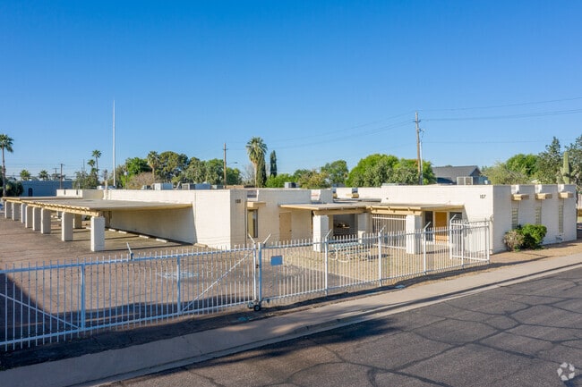

This Property Is For Sale
Property Detail
455 W 5Th Pl
135-25-041Y
POR SE4 SE4 SEC 16 T1N R5E DAF COM S4 COR SD SEC TH N 88D 57M E 1945.53F TH N 634.42F TH N 88D 56M E 397.53F TO POB TH NWLY ALG NON-TAN CUR TO LFT RAD 45F C/A 128D 56M 101.27F TH SWLY ALG REV CUR RAD 45F C/A 38D 56M 30.59F TH S 88D 56M W 249.85F TH N
Officebuilding
MARICOPA
LC
Arizona
C and X Area of minimal flood hazard, usually depicted on FIRMs as above the 500-year flood level.
1.91 AC
2025
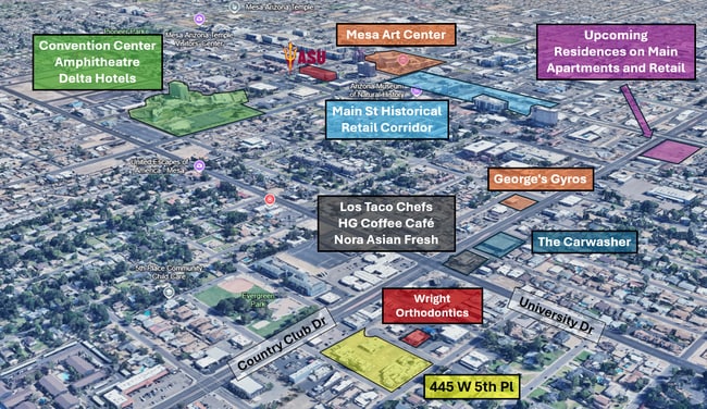
Mesa Downtown
2025
Phoenix
421102
Phoenix-Mesa-Chandler, AZ
18,206 SF
NEARBY LISTINGS FOR SALE OR LEASE
DEMOGRAPHICS near 455 W 5Th Pl
1 mile
3 mile
5 mile
2025 Total Population
23,004
163,018
354,480
2030 Population
24,359
169,281
367,850
Pop Growth 2025-2030
+ 5.89%
+ 3.84%
+ 3.77%
Average Age
38
35
37
2025 Total Households
9,125
60,854
137,145
HH Growth 2025-2030
+ 6.31%
+ 4.00%
+ 3.96%
Median Household Inc
$50,935
$60,794
$69,708
Avg Household Size
2.30
2.60
2.50
2025 Avg HH Vehicles
1.00
2.00
2.00
Median Home Value
$395,200
$361,173
$405,224
Median Year Built
1981
1980
1981
Nearby Places
Map Layers
Map Styles
 Street
 Aerial
Transit
 Traffic
 Biking
Places
Listings with unknown addresses are not visible on the map
- Restaurants
- Banks
- Shops
- Fitness
- Groceries
PUBLIC TRANSPORTATION
TRANSIT/SUBWAY
Country Club/Main St (Valley Metro Rail - Valley Metro (Phoenix Light Rail))
Drive
Walk
Distance
Country Club/Main St (Valley Metro Rail - Valley Metro (Phoenix Light Rail))
2 min
15 min
0.8 mi
AIRPORT
Phoenix Sky Harbor International
Drive
Walk
Distance
Phoenix Sky Harbor International
18 min
11.5 mi
Phoenix-Mesa Gateway
Drive
Walk
Distance
Phoenix-Mesa Gateway
28 min
18.2 mi
Freight Ports
Port of San Diego
Drive
Walk
Distance
Port of San Diego
411 min
374.2 mi
Nearby Properties
Address
Land Use
TOTAL SIZE
Lot Size
Zoning
Address
Land Use
TOTAL SIZE
Lot Size
Zoning
439,211 SF
77.92 AC
C-G
Address
Land Use
TOTAL SIZE
Lot Size
Zoning
127,962 SF
18.60 AC
I-1
Address
Land Use
TOTAL SIZE
Lot Size
Zoning
805,814 SF
115.19 AC
C-G
Address
Land Use
TOTAL SIZE
Lot Size
Zoning
8.79 AC
PF
Address
Land Use
TOTAL SIZE
Lot Size
Zoning
197,454 SF
18.97 AC
PF
Address
Land Use
TOTAL SIZE
Lot Size
Zoning
377,442 SF
0.21 AC
C-DT
Address
Land Use
TOTAL SIZE
Lot Size
Zoning
267,023 SF
19.58 AC
PEP
Address
Land Use
TOTAL SIZE
Lot Size
Zoning
485,625 SF
45.99 AC
PF
Address
Land Use
TOTAL SIZE
Lot Size
Zoning
32,619 SF
2.40 AC
C-G
Address
Land Use
TOTAL SIZE
Lot Size
Zoning
501,927 SF
8.13 AC
GC
Address
Land Use
TOTAL SIZE
Lot Size
Zoning
13,336 SF
1.98 AC
I-2
Address
Land Use
TOTAL SIZE
Lot Size
Zoning
579,506 SF
17.78 AC
PF
Address
Land Use
TOTAL SIZE
Lot Size
Zoning
357,952 SF
33.73 AC
LI
Address
Land Use
TOTAL SIZE
Lot Size
Zoning
418,678 SF
18.63 AC
C-G
Address
Land Use
TOTAL SIZE
Lot Size
Zoning
407,570 SF
6.22 AC
PEP
Address
Land Use
TOTAL SIZE
Lot Size
Zoning
23,030 SF
0.99 AC
M-H
Address
Land Use
TOTAL SIZE
Lot Size
Zoning
454,015 SF
10.03 AC
DB1
Address
Land Use
TOTAL SIZE
Lot Size
Zoning
322,662 SF
9.29 AC
R-6
Address
Land Use
TOTAL SIZE
Lot Size
Zoning
1.46 AC
C-G
Address
Land Use
TOTAL SIZE
Lot Size
Zoning
632,909 SF
5.83 AC
C-G
Address
Land Use
TOTAL SIZE
Lot Size
Zoning
160,533 SF
7.59 AC
GC
Address
Land Use
TOTAL SIZE
Lot Size
Zoning
387,531 SF
18.47 AC
M-H
Address
Land Use
TOTAL SIZE
Lot Size
Zoning
478,411 SF
4.07 AC
CDT
Address
Land Use
TOTAL SIZE
Lot Size
Zoning
210,613 SF
15.50 AC
I-1
Address
Land Use
TOTAL SIZE
Lot Size
Zoning
199,472 SF
4.79 AC
C-DT
Address
Land Use
TOTAL SIZE
Lot Size
Zoning
152,199 SF
21.96 AC
C-G
Address
Land Use
TOTAL SIZE
Lot Size
Zoning
236,345 SF
10.28 AC
LC
Address
Land Use
TOTAL SIZE
Lot Size
Zoning
307,038 SF
16.29 AC
M-H
Address
Land Use
TOTAL SIZE
Lot Size
Zoning
172,200 SF
8.89 AC
PF
Address
Land Use
TOTAL SIZE
Lot Size
Zoning
79,452 SF
37.59 AC
PF
The World's #1 Commercial Real Estate Marketplace
Connect with us
© 2026 CoStar Group
The information above has been obtained from sources believed reliable. While we do not doubt its accuracy we have not verified it and make no guarantee, warranty or representation about it. It is your responsibility to independently confirm its accuracy and completeness. Any projections, opinions, assumptions, or estimates used are for example only and do not represent the current or future performance of the property. The value of this transaction to you depends on tax and other factors which should be evaluated by your tax, financial, and legal advisors. You and your advisors should conduct a careful, independent investigation of the property to determine to your satisfaction the suitability of the property for your needs.