Property Record
4450 E State Highway 29, Bertram, TX 78605
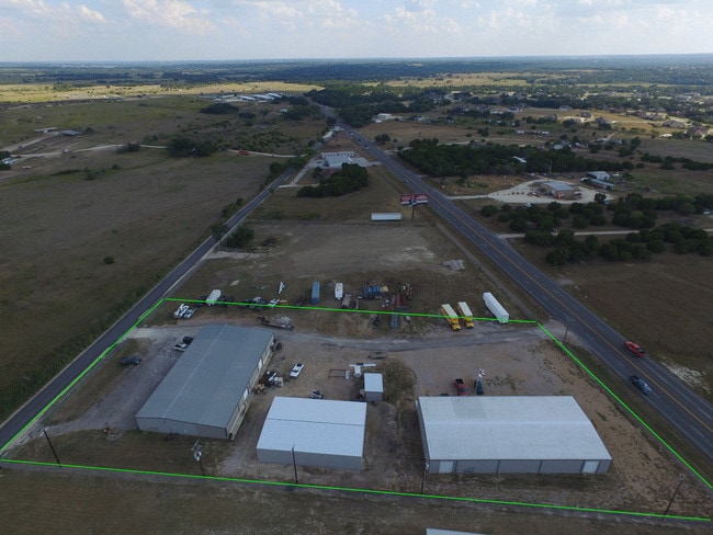

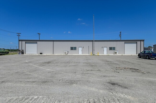
Property Detail
4450 E State Highway 29
11548
S3940 COUNTY LINE ESTATES LOT 5A & 5B BLK 1 5.0
Commercialnec
Burnet
B and X Area of moderate flood hazard, usually the area between the limits of the 100-year and 500-year floods.
Texas
2024
5a,5b
2025
5 AC
960102
Texas Hill Country
16,948 SF
Other Market Areas
NEARBY LISTINGS FOR SALE OR LEASE
-
-
View all Bertram listings for lease on LoopNet.com
DEMOGRAPHICS near 4450 E State Highway 29
1 mile
3 mile
5 mile
2025 Total Population
687
3,276
10,932
2030 Population
771
3,723
12,427
Pop Growth 2025-2030
+ 12.23%
+ 13.64%
+ 13.68%
Average Age
41
40
40
2025 Total Households
244
1,145
3,750
HH Growth 2025-2030
+ 12.30%
+ 13.80%
+ 13.87%
Median Household Inc
$95,312
$89,962
$93,866
Avg Household Size
2.80
2.80
2.90
2025 Avg HH Vehicles
2.00
2.00
2.00
Median Home Value
$502,809
$555,907
$581,904
Median Year Built
2005
2006
2007
Nearby Places
Map Layers
Map Styles
 Street
 Aerial
Transit
 Traffic
 Biking
Places
Listings with unknown addresses are not visible on the map
- Restaurants
- Banks
- Shops
- Fitness
- Groceries
PUBLIC TRANSPORTATION
AIRPORT
Robert Gray AAF
Drive
Walk
Distance
Robert Gray AAF
64 min
41.3 mi
Freight Ports
Calhoun Port
Drive
Walk
Distance
Calhoun Port
230 min
194.2 mi
SALE & LEASE HISTORY
LISTING DATE
SALE/LEASE

Sep 29, 2019
For Sale
Jul 14, 2021
For Lease
Nearby Properties
Address
Land Use
TOTAL SIZE
Lot Size
Zoning
Address
Land Use
TOTAL SIZE
Lot Size
Zoning
81,936 SF
19.99 AC
Address
Land Use
TOTAL SIZE
Lot Size
Zoning
84,625 SF
62.40 AC
Address
Land Use
TOTAL SIZE
Lot Size
Zoning
5,772 SF
229.19 AC
Address
Land Use
TOTAL SIZE
Lot Size
Zoning
139.38 AC
Address
Land Use
TOTAL SIZE
Lot Size
Zoning
31,080 SF
15 AC
Address
Land Use
TOTAL SIZE
Lot Size
Zoning
25,500 SF
10.33 AC
Address
Land Use
TOTAL SIZE
Lot Size
Zoning
Address
Land Use
TOTAL SIZE
Lot Size
Zoning
29,340 SF
3 AC
Address
Land Use
TOTAL SIZE
Lot Size
Zoning
Address
Land Use
TOTAL SIZE
Lot Size
Zoning
84,102 SF
10.76 AC
Address
Land Use
TOTAL SIZE
Lot Size
Zoning
20,300 SF
5.03 AC
Address
Land Use
TOTAL SIZE
Lot Size
Zoning
6,000 SF
15.06 AC
Address
Land Use
TOTAL SIZE
Lot Size
Zoning
23.78 AC
Address
Land Use
TOTAL SIZE
Lot Size
Zoning
1,075 SF
9.64 AC
Address
Land Use
TOTAL SIZE
Lot Size
Zoning
7,200 SF
5.22 AC
Address
Land Use
TOTAL SIZE
Lot Size
Zoning
5,893 SF
12.57 AC
Address
Land Use
TOTAL SIZE
Lot Size
Zoning
25,130 SF
5 AC
Address
Land Use
TOTAL SIZE
Lot Size
Zoning
55.98 AC
Address
Land Use
TOTAL SIZE
Lot Size
Zoning
9,648 SF
4.59 AC
Address
Land Use
TOTAL SIZE
Lot Size
Zoning
4,889 SF
5 AC
Address
Land Use
TOTAL SIZE
Lot Size
Zoning
3,089 SF
19.99 AC
Address
Land Use
TOTAL SIZE
Lot Size
Zoning
Address
Land Use
TOTAL SIZE
Lot Size
Zoning
5,536 SF
5.18 AC
Address
Land Use
TOTAL SIZE
Lot Size
Zoning
2,856 SF
10.64 AC
Address
Land Use
TOTAL SIZE
Lot Size
Zoning
7,425 SF
5.05 AC
Address
Land Use
TOTAL SIZE
Lot Size
Zoning
47.45 AC
Address
Land Use
TOTAL SIZE
Lot Size
Zoning
4,443 SF
5 AC
Address
Land Use
TOTAL SIZE
Lot Size
Zoning
5,474 SF
10.05 AC
Address
Land Use
TOTAL SIZE
Lot Size
Zoning
41.57 AC
The World's #1 Commercial Real Estate Marketplace
Connect with us
© 2026 CoStar Group
The information above has been obtained from sources believed reliable. While we do not doubt its accuracy we have not verified it and make no guarantee, warranty or representation about it. It is your responsibility to independently confirm its accuracy and completeness. Any projections, opinions, assumptions, or estimates used are for example only and do not represent the current or future performance of the property. The value of this transaction to you depends on tax and other factors which should be evaluated by your tax, financial, and legal advisors. You and your advisors should conduct a careful, independent investigation of the property to determine to your satisfaction the suitability of the property for your needs.