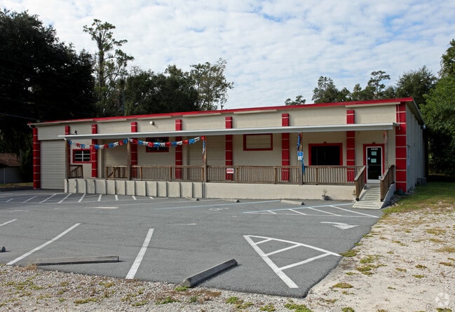
Property Record
4450 S Pine Ave, Ocala, FL 34480

Current Lease Availabilities
NEARBY LISTINGS FOR SALE OR LEASE
Property Detail
4450 S Pine Ave
Ocala, FL
Roosevelt Village
3111-000-018
SEC 33 TWP 15 RGE 22 PLAT BOOK F PAGE 019 ROOSEVELT VILLAGE UNIT 1 BEG AT SE COR LOT 1 BLK G TH S 70-13-00 W 175.62 FT N 26- 35- 52 W 120 FT, N 70-13-00 E 175.62 FT TO HWY 441 R/W LINE TH S 26-35-52 E 120 FT TO POB
Vehiclerentalsvehiclesales
Marion
X
Florida
12083C0538D
1
2025
0.48 AC
2025
Greater Ocala
002402
Ocala
12,750 SF
DEMOGRAPHICS near 4450 S Pine Ave
1 Mile
3 Mile
5 Mile
2024 Total Population
3,315
30,597
96,645
2029 Population
3,705
34,412
108,986
Pop Growth 2024-2029
+ 11.76%
+ 12.47%
+ 12.77%
Average Age
41
42
41
2024 Total Households
1,275
12,033
38,242
HH Growth 2024-2029
+ 11.69%
+ 12.42%
+ 12.76%
Median Household Inc
$110,171
$73,386
$57,642
Avg Household Size
2.60
2.40
2.40
2024 Avg HH Vehicles
2.00
2.00
2.00
Median Home Value
$276,570
$266,460
$199,427
Median Year Built
1987
1984
1985
Nearby Places
Map Layers
Map Styles
 Street
 Aerial
- Restaurants
- Banks
- Shops
- Fitness
- Groceries
Nearby Properties
Address
Land Use
TOTAL SIZE
Lot Size
Zoning
Address
Land Use
TOTAL SIZE
Lot Size
Zoning
207,950 SF
14.08 AC
INST
Address
Land Use
TOTAL SIZE
Lot Size
Zoning
331,687 SF
11.66 AC
INST
Address
Land Use
TOTAL SIZE
Lot Size
Zoning
189,025 SF
35.42 AC
PD08
Address
Land Use
TOTAL SIZE
Lot Size
Zoning
211,884 SF
80 AC
GU
Address
Land Use
TOTAL SIZE
Lot Size
Zoning
88,462 SF
31.76 AC
INST
Address
Land Use
TOTAL SIZE
Lot Size
Zoning
89,719 SF
15.16 AC
PD12
Address
Land Use
TOTAL SIZE
Lot Size
Zoning
30,274 SF
3.94 AC
FBC
Address
Land Use
TOTAL SIZE
Lot Size
Zoning
56,484 SF
12.50 AC
PD14
Address
Land Use
TOTAL SIZE
Lot Size
Zoning
180,334 SF
24.29 AC
INST
Address
Land Use
TOTAL SIZE
Lot Size
Zoning
101,892 SF
16.81 AC
INST
Address
Land Use
TOTAL SIZE
Lot Size
Zoning
95,552 SF
11.31 AC
SC
Address
Land Use
TOTAL SIZE
Lot Size
Zoning
5,815 SF
186.33 AC
GU
Address
Land Use
TOTAL SIZE
Lot Size
Zoning
71,065 SF
12.01 AC
B2
Address
Land Use
TOTAL SIZE
Lot Size
Zoning
49,963 SF
9.84 AC
PD14
Address
Land Use
TOTAL SIZE
Lot Size
Zoning
107,993 SF
66.76 AC
GU
Address
Land Use
TOTAL SIZE
Lot Size
Zoning
58,040 SF
10.24 AC
INST
Address
Land Use
TOTAL SIZE
Lot Size
Zoning
82,124 SF
20 AC
A1
Address
Land Use
TOTAL SIZE
Lot Size
Zoning
48,056 SF
9.02 AC
R3
Address
Land Use
TOTAL SIZE
Lot Size
Zoning
46,008 SF
10.25 AC
R3
Address
Land Use
TOTAL SIZE
Lot Size
Zoning
70,325 SF
11.62 AC
PD14
Address
Land Use
TOTAL SIZE
Lot Size
Zoning
34,531 SF
3.13 AC
R3
Address
Land Use
TOTAL SIZE
Lot Size
Zoning
390,591 SF
30.62 AC
M2
Address
Land Use
TOTAL SIZE
Lot Size
Zoning
64,190 SF
17.71 AC
INST
Address
Land Use
TOTAL SIZE
Lot Size
Zoning
55,590 SF
1.70 AC
O1
Address
Land Use
TOTAL SIZE
Lot Size
Zoning
11,340 SF
1.45 AC
B4
Address
Land Use
TOTAL SIZE
Lot Size
Zoning
12,200 SF
3.78 AC
OP
Address
Land Use
TOTAL SIZE
Lot Size
Zoning
42,222 SF
2.91 AC
B4
Address
Land Use
TOTAL SIZE
Lot Size
Zoning
70,667 SF
20.30 AC
INST
Address
Land Use
TOTAL SIZE
Lot Size
Zoning
22,495 SF
2.26 AC
OP
Address
Land Use
TOTAL SIZE
Lot Size
Zoning
268,173 SF
18.70 AC
M2
The World's #1 Commercial Real Estate Marketplace
Connect with us
© 2026 CoStar Group
The information above has been obtained from sources believed reliable. While we do not doubt its accuracy we have not verified it and make no guarantee, warranty or representation about it. It is your responsibility to independently confirm its accuracy and completeness. Any projections, opinions, assumptions, or estimates used are for example only and do not represent the current or future performance of the property. The value of this transaction to you depends on tax and other factors which should be evaluated by your tax, financial, and legal advisors. You and your advisors should conduct a careful, independent investigation of the property to determine to your satisfaction the suitability of the property for your needs.