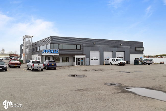
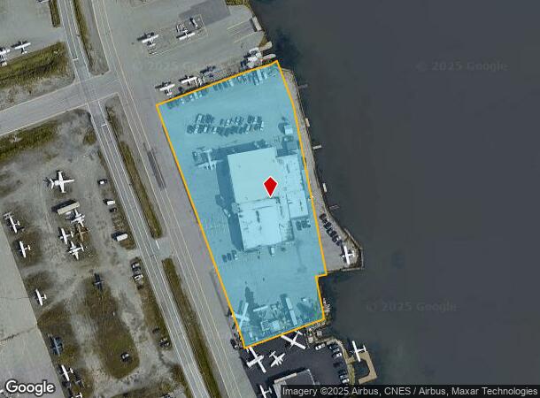
Property Record
4451 Aircraft Dr, Anchorage, AK 99502

NEARBY LISTINGS FOR SALE OR LEASE
Property Detail
4451 Aircraft Dr
Anchorage, AK
Intl Arpt
01027123001
ADA 31372 INTL ARPT BLK 11 LT 1, 1A
Transportnec
Anchorage
X
Alaska
0200050740D
1
2024
3.07 AC
2025
Spenard-10
002301
Anchorage
41,160 SF
DEMOGRAPHICS near 4451 Aircraft Dr
1 Mile
3 Mile
5 Mile
2024 Total Population
1,881
44,632
106,610
2029 Population
1,867
44,050
105,190
Pop Growth 2024-2029
(0.74%)
(1.30%)
(1.33%)
Average Age
39
39
39
2024 Total Households
765
18,295
43,491
HH Growth 2024-2029
(0.65%)
(1.36%)
(1.37%)
Median Household Inc
$109,564
$90,794
$85,520
Avg Household Size
2.40
2.30
2.30
2024 Avg HH Vehicles
2.00
2.00
2.00
Median Home Value
$309,844
$358,408
$348,876
Median Year Built
1984
1978
1978
Nearby Places
Map Layers
Map Styles
 Street
 Aerial
- Restaurants
- Banks
- Shops
- Fitness
- Groceries
PUBLIC TRANSPORTATION
AIRPORT
Ted Stevens Anchorage International
DRIVE
WALK
Distance
Ted Stevens Anchorage International
4 min
1.4 mi
Merrill Field
DRIVE
WALK
Distance
Merrill Field
17 min
8.2 mi
Freight Ports
Port of Anchorage
DRIVE
WALK
Distance
Port of Anchorage
17 min
8.3 mi
SALE & LEASE HISTORY
LISTING DATE
SALE/LEASE

Jul 03, 2019
For Lease
Nearby Properties
Address
Land Use
TOTAL SIZE
Lot Size
Zoning
Address
Land Use
TOTAL SIZE
Lot Size
Zoning
91,034 SF
63.70 AC
TR
Address
Land Use
TOTAL SIZE
Lot Size
Zoning
117,702 SF
9.85 AC
B3SL
Address
Land Use
TOTAL SIZE
Lot Size
Zoning
195,079 SF
44.79 AC
PLI
Address
Land Use
TOTAL SIZE
Lot Size
Zoning
267,442 SF
61.04 AC
PLI
Address
Land Use
TOTAL SIZE
Lot Size
Zoning
191.79 AC
PLI
Address
Land Use
TOTAL SIZE
Lot Size
Zoning
65,314 SF
111.15 AC
PLI
Address
Land Use
TOTAL SIZE
Lot Size
Zoning
121,359 SF
4.35 AC
B3SL
Address
Land Use
TOTAL SIZE
Lot Size
Zoning
66,354 SF
44.23 AC
I2
Address
Land Use
TOTAL SIZE
Lot Size
Zoning
134.97 AC
TR
Address
Land Use
TOTAL SIZE
Lot Size
Zoning
242,189 SF
21.83 AC
I2
Address
Land Use
TOTAL SIZE
Lot Size
Zoning
168,640 SF
3.38 AC
I2
Address
Land Use
TOTAL SIZE
Lot Size
Zoning
341,267 SF
5.51 AC
TR
Address
Land Use
TOTAL SIZE
Lot Size
Zoning
79.26 AC
PLI
Address
Land Use
TOTAL SIZE
Lot Size
Zoning
103,442 SF
3.50 AC
B3
Address
Land Use
TOTAL SIZE
Lot Size
Zoning
59,908 SF
5.54 AC
I1
Address
Land Use
TOTAL SIZE
Lot Size
Zoning
3,813 SF
31.29 AC
PLIP
Address
Land Use
TOTAL SIZE
Lot Size
Zoning
97,524 SF
6.85 AC
TR
Address
Land Use
TOTAL SIZE
Lot Size
Zoning
75,412 SF
3.32 AC
B3
Address
Land Use
TOTAL SIZE
Lot Size
Zoning
49,032 SF
3.07 AC
B3
Address
Land Use
TOTAL SIZE
Lot Size
Zoning
45,105 SF
10.96 AC
B3
Address
Land Use
TOTAL SIZE
Lot Size
Zoning
Address
Land Use
TOTAL SIZE
Lot Size
Zoning
72,470 SF
3.76 AC
B3
Address
Land Use
TOTAL SIZE
Lot Size
Zoning
54,285 SF
3.47 AC
B3SL
Address
Land Use
TOTAL SIZE
Lot Size
Zoning
23,800 SF
20.01 AC
I2
Address
Land Use
TOTAL SIZE
Lot Size
Zoning
53,693 SF
16.41 AC
I2
Address
Land Use
TOTAL SIZE
Lot Size
Zoning
73,200 SF
11.19 AC
TR
Address
Land Use
TOTAL SIZE
Lot Size
Zoning
41,406 SF
4.20 AC
B3SL
Address
Land Use
TOTAL SIZE
Lot Size
Zoning
27,522 SF
3.49 AC
B3
Address
Land Use
TOTAL SIZE
Lot Size
Zoning
42,649 SF
2.15 AC
B3
Address
Land Use
TOTAL SIZE
Lot Size
Zoning
132,267 SF
5.04 AC
I1
The World's #1 Commercial Real Estate Marketplace
Connect with us
© 2026 CoStar Group
The information above has been obtained from sources believed reliable. While we do not doubt its accuracy we have not verified it and make no guarantee, warranty or representation about it. It is your responsibility to independently confirm its accuracy and completeness. Any projections, opinions, assumptions, or estimates used are for example only and do not represent the current or future performance of the property. The value of this transaction to you depends on tax and other factors which should be evaluated by your tax, financial, and legal advisors. You and your advisors should conduct a careful, independent investigation of the property to determine to your satisfaction the suitability of the property for your needs.