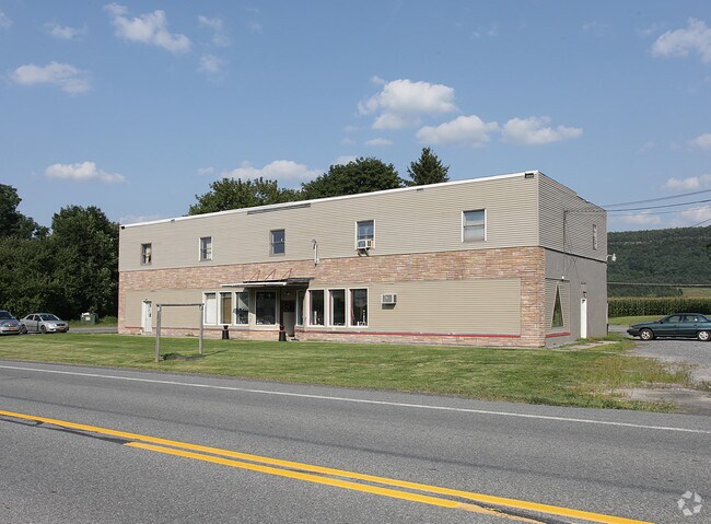
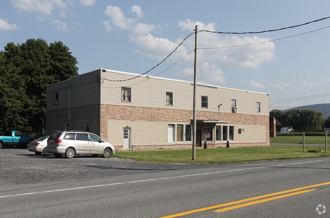
Property Record
4454 State Route 30, Middleburgh, NY 12122

Property Detail
4454 State Route 30
433889-106-000-0002-006-000-0000
COMM BLOCKS
Commercialbuilding
Schoharie
HB
New York
AE The base floodplain where base flood elevations are provided. AE Zones are now used on new format FIRMs instead of A1-A30 Zones.
6.000
2025
0.74 AC
2025
Schoharie County
740700
Albany/Schenectady/Troy
8,342 SF
Albany-Schenectady-Troy, NY
NEARBY LISTINGS FOR SALE OR LEASE
-
-
View all Middleburgh listings for sale on LoopNet.com
DEMOGRAPHICS near 4454 State Route 30
1 mile
3 mile
5 mile
2025 Total Population
721
2,316
4,829
2030 Population
709
2,270
4,733
Pop Growth 2025-2030
(1.66%)
(1.99%)
(1.99%)
Average Age
47
45
45
2025 Total Households
337
1,016
2,116
HH Growth 2025-2030
(2.08%)
(2.17%)
(2.08%)
Median Household Inc
$41,250
$52,419
$62,272
Avg Household Size
2.10
2.20
2.20
2025 Avg HH Vehicles
2.00
2.00
2.00
Median Home Value
$215,425
$211,555
$212,963
Median Year Built
1947
1950
1961
Nearby Places
Map Layers
Map Styles
 Street
 Aerial
Layers
 Traffic
 Biking
Places
Listings with unknown addresses are not visible on the map
- Restaurants
- Banks
- Shops
- Fitness
- Groceries
PUBLIC TRANSPORTATION
AIRPORT
Albany International
Drive
Walk
Distance
Albany International
58 min
40.2 mi
Freight Ports
Albany, NY Port
Drive
Walk
Distance
Albany, NY Port
58 min
43.5 mi
Nearby Properties
Address
Land Use
TOTAL SIZE
Lot Size
Zoning
Address
Land Use
TOTAL SIZE
Lot Size
Zoning
20.70 AC
Address
Land Use
TOTAL SIZE
Lot Size
Zoning
54,809 SF
24.67 AC
P
Address
Land Use
TOTAL SIZE
Lot Size
Zoning
7,900 SF
11 AC
R3
Address
Land Use
TOTAL SIZE
Lot Size
Zoning
15,428 SF
13.71 AC
HB
Address
Land Use
TOTAL SIZE
Lot Size
Zoning
3,048 SF
7.60 AC
C
Address
Land Use
TOTAL SIZE
Lot Size
Zoning
3,313 SF
16.28 AC
Address
Land Use
TOTAL SIZE
Lot Size
Zoning
Address
Land Use
TOTAL SIZE
Lot Size
Zoning
22,000 SF
4 AC
C
Address
Land Use
TOTAL SIZE
Lot Size
Zoning
6,350 SF
1.17 AC
Address
Land Use
TOTAL SIZE
Lot Size
Zoning
17.38 AC
R3
Address
Land Use
TOTAL SIZE
Lot Size
Zoning
0.58 AC
C
Address
Land Use
TOTAL SIZE
Lot Size
Zoning
13,428 SF
0.84 AC
C
Address
Land Use
TOTAL SIZE
Lot Size
Zoning
3.08 AC
R1
Address
Land Use
TOTAL SIZE
Lot Size
Zoning
16,110 SF
54.69 AC
R3
Address
Land Use
TOTAL SIZE
Lot Size
Zoning
9,364 SF
1.60 AC
HB
Address
Land Use
TOTAL SIZE
Lot Size
Zoning
0.90 AC
Address
Land Use
TOTAL SIZE
Lot Size
Zoning
Address
Land Use
TOTAL SIZE
Lot Size
Zoning
2,314 SF
3.30 AC
H
Address
Land Use
TOTAL SIZE
Lot Size
Zoning
Address
Land Use
TOTAL SIZE
Lot Size
Zoning
15.03 AC
R3
Address
Land Use
TOTAL SIZE
Lot Size
Zoning
2,520 SF
77.70 AC
A
Address
Land Use
TOTAL SIZE
Lot Size
Zoning
2,628 SF
3.30 AC
R3
Address
Land Use
TOTAL SIZE
Lot Size
Zoning
3,312 SF
3.78 AC
A
Address
Land Use
TOTAL SIZE
Lot Size
Zoning
6,120 SF
6.99 AC
HB
Address
Land Use
TOTAL SIZE
Lot Size
Zoning
7,964 SF
0.35 AC
R2
Address
Land Use
TOTAL SIZE
Lot Size
Zoning
5,424 SF
0.50 AC
R2
Address
Land Use
TOTAL SIZE
Lot Size
Zoning
Address
Land Use
TOTAL SIZE
Lot Size
Zoning
5,760 SF
0.60 AC
C
Address
Land Use
TOTAL SIZE
Lot Size
Zoning
2,100 SF
1.25 AC
Address
Land Use
TOTAL SIZE
Lot Size
Zoning
1,710 SF
0.48 AC
C
The World's #1 Commercial Real Estate Marketplace
Connect with us
© 2026 CoStar Group
The information above has been obtained from sources believed reliable. While we do not doubt its accuracy we have not verified it and make no guarantee, warranty or representation about it. It is your responsibility to independently confirm its accuracy and completeness. Any projections, opinions, assumptions, or estimates used are for example only and do not represent the current or future performance of the property. The value of this transaction to you depends on tax and other factors which should be evaluated by your tax, financial, and legal advisors. You and your advisors should conduct a careful, independent investigation of the property to determine to your satisfaction the suitability of the property for your needs.