Property Record
4455 Wesley Dr, Austell, GA 30106

Save to a Folder
{{folder.Name}}
{{folder.ListingIds.length}} Properties
{{folder.ListingIds.length}} Property
Create a New Folder
This Property Is For Sale
Property Detail
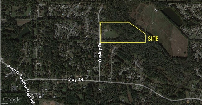
4455 Wesley Dr
19-1015-003
COBB
Publicschool
Georgia
R20
1057
AE The base floodplain where base flood elevations are provided. AE Zones are now used on new format FIRMs instead of A1-A30 Zones.
18.26 AC
0
Kennesaw/Town Center
2025
Atlanta
031409
Atlanta-Sandy Springs-Roswell, GA
NEARBY LISTINGS FOR SALE OR LEASE
DEMOGRAPHICS near 4455 Wesley Dr
1 mile
3 mile
5 mile
2025 Total Population
4,073
52,915
143,273
2030 Population
4,190
54,672
148,146
Pop Growth 2025-2030
+ 2.87%
+ 3.32%
+ 3.40%
Average Age
39
39
39
2025 Total Households
1,414
18,727
50,955
HH Growth 2025-2030
+ 2.90%
+ 3.31%
+ 3.41%
Median Household Inc
$68,960
$75,639
$84,084
Avg Household Size
2.80
2.70
2.70
2025 Avg HH Vehicles
2.00
2.00
2.00
Median Home Value
$268,666
$316,979
$343,519
Median Year Built
1991
1988
1989
Nearby Places
Map Layers
Map Styles
 Street
 Aerial
Layers
 Traffic
 Biking
Places
Listings with unknown addresses are not visible on the map
- Restaurants
- Banks
- Shops
- Fitness
- Groceries
PUBLIC TRANSPORTATION
AIRPORT
Hartsfield - Jackson Atlanta International
Drive
Walk
Distance
Hartsfield - Jackson Atlanta International
45 min
29.1 mi
Nearby Properties
Address
Land Use
TOTAL SIZE
Lot Size
Zoning
Address
Land Use
TOTAL SIZE
Lot Size
Zoning
494,972 SF
25.60 AC
CF
Address
Land Use
TOTAL SIZE
Lot Size
Zoning
403,898 SF
37.53 AC
RM-12
Address
Land Use
TOTAL SIZE
Lot Size
Zoning
18.80 AC
MXU
Address
Land Use
TOTAL SIZE
Lot Size
Zoning
272,170 SF
26.40 AC
RM-12
Address
Land Use
TOTAL SIZE
Lot Size
Zoning
238,984 SF
17.51 AC
RM-12
Address
Land Use
TOTAL SIZE
Lot Size
Zoning
9,882 SF
4.61 AC
CBD
Address
Land Use
TOTAL SIZE
Lot Size
Zoning
Address
Land Use
TOTAL SIZE
Lot Size
Zoning
209,649 SF
13.51 AC
RM-12
Address
Land Use
TOTAL SIZE
Lot Size
Zoning
219,402 SF
10.33 AC
RM-12
Address
Land Use
TOTAL SIZE
Lot Size
Zoning
Address
Land Use
TOTAL SIZE
Lot Size
Zoning
179,048 SF
25.97 AC
RM-12
Address
Land Use
TOTAL SIZE
Lot Size
Zoning
118,069 SF
0.38 AC
OI
Address
Land Use
TOTAL SIZE
Lot Size
Zoning
188,988 SF
15.30 AC
OI
Address
Land Use
TOTAL SIZE
Lot Size
Zoning
92,468 SF
13.69 AC
RM-8
Address
Land Use
TOTAL SIZE
Lot Size
Zoning
78.60 AC
R20
Address
Land Use
TOTAL SIZE
Lot Size
Zoning
98,574 SF
10.27 AC
CRC
Address
Land Use
TOTAL SIZE
Lot Size
Zoning
170,892 SF
29.16 AC
CRC/LRO
Address
Land Use
TOTAL SIZE
Lot Size
Zoning
79,348 SF
12.04 AC
CRC
Address
Land Use
TOTAL SIZE
Lot Size
Zoning
134,592 SF
13.43 AC
CBD
Address
Land Use
TOTAL SIZE
Lot Size
Zoning
12,374 SF
1.42 AC
CBD
Address
Land Use
TOTAL SIZE
Lot Size
Zoning
104,538 SF
9.18 AC
RM-12
Address
Land Use
TOTAL SIZE
Lot Size
Zoning
101,340 SF
4.24 AC
CRC
Address
Land Use
TOTAL SIZE
Lot Size
Zoning
44,097 SF
3.45 AC
OI
Address
Land Use
TOTAL SIZE
Lot Size
Zoning
38,418 SF
2.27 AC
GC
Address
Land Use
TOTAL SIZE
Lot Size
Zoning
175,923 SF
12.75 AC
GC
Address
Land Use
TOTAL SIZE
Lot Size
Zoning
122,323 SF
9.39 AC
CRC/WS
Address
Land Use
TOTAL SIZE
Lot Size
Zoning
40,600 SF
4.99 AC
NS/WS
Address
Land Use
TOTAL SIZE
Lot Size
Zoning
104,746 SF
16.19 AC
CRC/LRO
Address
Land Use
TOTAL SIZE
Lot Size
Zoning
60,630 SF
6.78 AC
CRC/WS
Address
Land Use
TOTAL SIZE
Lot Size
Zoning
12.01 AC
CRC
The World's #1 Commercial Real Estate Marketplace
Connect with us
© 2026 CoStar Group
The information above has been obtained from sources believed reliable. While we do not doubt its accuracy we have not verified it and make no guarantee, warranty or representation about it. It is your responsibility to independently confirm its accuracy and completeness. Any projections, opinions, assumptions, or estimates used are for example only and do not represent the current or future performance of the property. The value of this transaction to you depends on tax and other factors which should be evaluated by your tax, financial, and legal advisors. You and your advisors should conduct a careful, independent investigation of the property to determine to your satisfaction the suitability of the property for your needs.