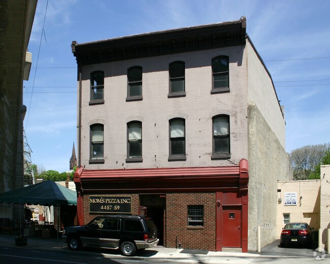
Property Record
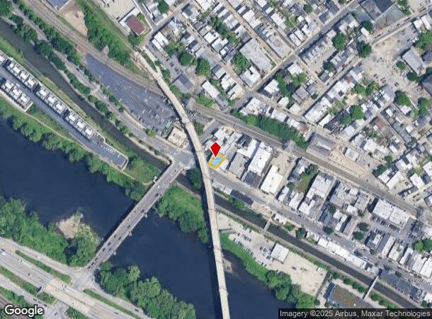
4457 Main St, Philadelphia, PA 19127
NEARBY LISTINGS FOR SALE OR LEASE
Property Detail
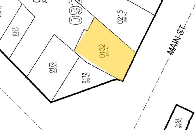
4457 Main St
882779700
281 1/8 N CARSON ST
Commercialnec
Philadelphia
X
Pennsylvania
42091C0388G
132
2024
0.05 AC
2026
Northwest Philadelphia
021400
Philadelphia
5,130 SF
Philadelphia-Camden-Wilmington, PA-NJ-DE-MD
DEMOGRAPHICS near 4457 Main St
1 Mile
3 Mile
5 Mile
2024 Total Population
24,801
154,343
640,047
2029 Population
24,192
152,853
629,902
Pop Growth 2024-2029
(2.46%)
(0.97%)
(1.59%)
Average Age
37
40
39
2024 Total Households
11,577
69,483
263,935
HH Growth 2024-2029
(2.68%)
(1.27%)
(1.82%)
Median Household Inc
$95,573
$80,923
$51,804
Avg Household Size
2.10
2.10
2.30
2024 Avg HH Vehicles
2.00
1.00
1.00
Median Home Value
$301,438
$336,249
$237,060
Median Year Built
1948
1954
1948
Nearby Places
- Restaurants
- Banks
- Shops
- Fitness
- Groceries
PUBLIC TRANSPORTATION
TRANSIT/SUBWAY
Manayunk (R6 - Southeastern Pennsylvania Transportation Authority Regional Rail (SEPTA Regional Rail))
DRIVE
WALK
Distance
Manayunk (R6 - Southeastern Pennsylvania Transportation Authority Regional Rail (SEPTA Regional Rail))
1 min
2 min
0.1 mi
Ivy Ridge (R6 - Southeastern Pennsylvania Transportation Authority Regional Rail (SEPTA Regional Rail))
DRIVE
WALK
Distance
Ivy Ridge (R6 - Southeastern Pennsylvania Transportation Authority Regional Rail (SEPTA Regional Rail))
4 min
15 min
0.8 mi
COMMUTER RAIL
Manayunk (R6 - Southeastern Pennsylvania Transportation Authority Regional Rail (SEPTA Regional Rail))
DRIVE
WALK
Distance
Manayunk (R6 - Southeastern Pennsylvania Transportation Authority Regional Rail (SEPTA Regional Rail))
1 min
2 min
0.1 mi
Ivy Ridge (R6 - Southeastern Pennsylvania Transportation Authority Regional Rail (SEPTA Regional Rail))
DRIVE
WALK
Distance
Ivy Ridge (R6 - Southeastern Pennsylvania Transportation Authority Regional Rail (SEPTA Regional Rail))
4 min
15 min
0.8 mi
AIRPORT
Philadelphia International
DRIVE
WALK
Distance
Philadelphia International
29 min
16.0 mi
Trenton Mercer
DRIVE
WALK
Distance
Trenton Mercer
57 min
34.0 mi
Freight Ports
Port of Philadelphia
DRIVE
WALK
Distance
Port of Philadelphia
21 min
11.0 mi
Nearby Properties
Address
Land Use
TOTAL SIZE
Lot Size
Zoning
Address
Land Use
TOTAL SIZE
Lot Size
Zoning
391,885 SF
7.15 AC
RM4
Address
Land Use
TOTAL SIZE
Lot Size
Zoning
455,889 SF
33 AC
I2
Address
Land Use
TOTAL SIZE
Lot Size
Zoning
520,280 SF
14.84 AC
RM3
Address
Land Use
TOTAL SIZE
Lot Size
Zoning
22,648 SF
38.69 AC
RM3
Address
Land Use
TOTAL SIZE
Lot Size
Zoning
1,455,130 SF
6.80 AC
RSD3
Address
Land Use
TOTAL SIZE
Lot Size
Zoning
451,857 SF
3.57 AC
CMX2
Address
Land Use
TOTAL SIZE
Lot Size
Zoning
609,000 SF
22.44 AC
RM2
Address
Land Use
TOTAL SIZE
Lot Size
Zoning
425,535 SF
4.60 AC
RM3
Address
Land Use
TOTAL SIZE
Lot Size
Zoning
563,768 SF
20.20 AC
RM2
Address
Land Use
TOTAL SIZE
Lot Size
Zoning
253,400 SF
10.90 AC
RM2
Address
Land Use
TOTAL SIZE
Lot Size
Zoning
121,578 SF
3.13 AC
RSA3
Address
Land Use
TOTAL SIZE
Lot Size
Zoning
587,330 SF
34.37 AC
SPINS
Address
Land Use
TOTAL SIZE
Lot Size
Zoning
368,612 SF
20.06 AC
CMX2
Address
Land Use
TOTAL SIZE
Lot Size
Zoning
511,806 SF
1.70 AC
RM4
Address
Land Use
TOTAL SIZE
Lot Size
Zoning
418,017 SF
19.10 AC
CO
Address
Land Use
TOTAL SIZE
Lot Size
Zoning
3,000 SF
6.77 AC
RSD1
Address
Land Use
TOTAL SIZE
Lot Size
Zoning
495,017 SF
9.65 AC
CMX3
Address
Land Use
TOTAL SIZE
Lot Size
Zoning
194,304 SF
9.33 AC
RM2
Address
Land Use
TOTAL SIZE
Lot Size
Zoning
409,386 SF
33.36 AC
R2
Address
Land Use
TOTAL SIZE
Lot Size
Zoning
210,738 SF
8.73 AC
RM4
Address
Land Use
TOTAL SIZE
Lot Size
Zoning
193,228 SF
18.06 AC
RMX1
Address
Land Use
TOTAL SIZE
Lot Size
Zoning
281,508 SF
18.93 AC
SPINS
Address
Land Use
TOTAL SIZE
Lot Size
Zoning
218,030 SF
23.75 AC
CA2
Address
Land Use
TOTAL SIZE
Lot Size
Zoning
180,750 SF
1.60 AC
CMX3
Address
Land Use
TOTAL SIZE
Lot Size
Zoning
299,678 SF
14.06 AC
R4
Address
Land Use
TOTAL SIZE
Lot Size
Zoning
178,738 SF
6.11 AC
CMX3
Address
Land Use
TOTAL SIZE
Lot Size
Zoning
568,410 SF
33.08 AC
RMX1
Address
Land Use
TOTAL SIZE
Lot Size
Zoning
530,525 SF
36.29 AC
R3
Address
Land Use
TOTAL SIZE
Lot Size
Zoning
293,734 SF
4.42 AC
ICMX
Address
Land Use
TOTAL SIZE
Lot Size
Zoning
258,000 SF
1.90 AC
CMX2
The World's #1 Commercial Real Estate Marketplace
Connect with us
© 2025 CoStar Group
The information above has been obtained from sources believed reliable. While we do not doubt its accuracy we have not verified it and make no guarantee, warranty or representation about it. It is your responsibility to independently confirm its accuracy and completeness. Any projections, opinions, assumptions, or estimates used are for example only and do not represent the current or future performance of the property. The value of this transaction to you depends on tax and other factors which should be evaluated by your tax, financial, and legal advisors. You and your advisors should conduct a careful, independent investigation of the property to determine to your satisfaction the suitability of the property for your needs.