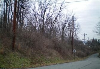
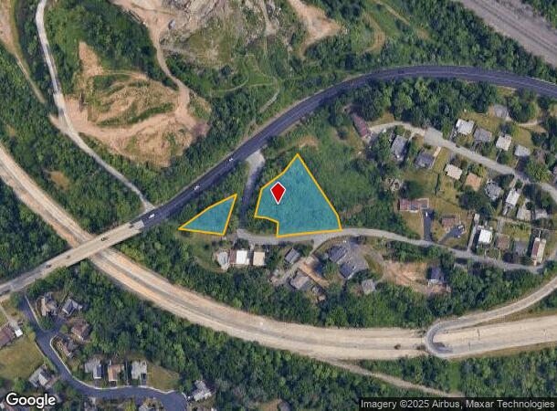
Property Record
446 Lower East Valley Forge Rd, King Of Prussia, PA 19406
NEARBY LISTINGS FOR SALE OR LEASE
Property Detail
446 Lower East Valley Forge Rd
Philadelphia-Camden-Wilmington, PA-NJ-DE-MD
ASSESSOR BLOCK-UNIT NUMBER 16-11
58-00-19333-004
Montgomery
Residentialacreage
Pennsylvania
X
11
42029C0120G
0.92 AC
2024
King of Prussia/Wayne
2025
Philadelphia
205805
DEMOGRAPHICS near 446 Lower East Valley Forge Rd
1 Mile
3 Mile
5 Mile
2024 Total Population
15,117
92,443
202,953
2029 Population
15,343
94,100
207,167
Pop Growth 2024-2029
+ 1.50%
+ 1.79%
+ 2.08%
Average Age
36
39
40
2024 Total Households
5,472
36,796
81,116
HH Growth 2024-2029
+ 1.52%
+ 1.87%
+ 2.21%
Median Household Inc
$63,953
$80,072
$99,286
Avg Household Size
2.60
2.40
2.40
2024 Avg HH Vehicles
2.00
2.00
2.00
Median Home Value
$290,231
$282,179
$378,478
Median Year Built
1952
1964
1969
Nearby Places
Map Layers
Map Styles
 Street
 Aerial
- Restaurants
- Banks
- Shops
- Fitness
- Groceries
PUBLIC TRANSPORTATION
TRANSIT/SUBWAY
Bridgeport (Norristown High Speed Line - SEPTA, Route 100 - SEPTA)
DRIVE
WALK
Distance
Bridgeport (Norristown High Speed Line - SEPTA, Route 100 - SEPTA)
2 min
13 min
0.7 mi
COMMUTER RAIL
Norristown Transportation Center (R6 Line) (Manayunk/Norristown Line - SEPTA, R6 - SEPTA)
DRIVE
WALK
Distance
Norristown Transportation Center (R6 Line) (Manayunk/Norristown Line - SEPTA, R6 - SEPTA)
3 min
1.2 mi
Main Street (Norristown) (R6 - Southeastern Pennsylvania Transportation Authority Regional Rail (SEPTA Regional Rail))
DRIVE
WALK
Distance
Main Street (Norristown) (R6 - Southeastern Pennsylvania Transportation Authority Regional Rail (SEPTA Regional Rail))
4 min
1.7 mi
AIRPORT
Philadelphia International
DRIVE
WALK
Distance
Philadelphia International
44 min
26.8 mi
Freight Ports
Port of Philadelphia
DRIVE
WALK
Distance
Port of Philadelphia
38 min
23.1 mi
SALE & LEASE HISTORY
LISTING DATE
SALE/LEASE

Oct 11, 2016
For Sale
Mar 08, 2017
For Sale
Jun 03, 2017
For Sale
Jun 02, 2017
For Sale
Nearby Properties
Address
Land Use
TOTAL SIZE
Lot Size
Zoning
Address
Land Use
TOTAL SIZE
Lot Size
Zoning
2,373,472 SF
96.77 AC
SC
Address
Land Use
TOTAL SIZE
Lot Size
Zoning
1,807,465 SF
120.12 AC
R2
Address
Land Use
TOTAL SIZE
Lot Size
Zoning
679,715 SF
58.23 AC
R2
Address
Land Use
TOTAL SIZE
Lot Size
Zoning
1,724,092 SF
24 AC
SC
Address
Land Use
TOTAL SIZE
Lot Size
Zoning
388,042 SF
24.45 AC
SM
Address
Land Use
TOTAL SIZE
Lot Size
Zoning
454,933 SF
17.85 AC
SM
Address
Land Use
TOTAL SIZE
Lot Size
Zoning
872,232 SF
51.99 AC
G
Address
Land Use
TOTAL SIZE
Lot Size
Zoning
422,975 SF
92.05 AC
RA
Address
Land Use
TOTAL SIZE
Lot Size
Zoning
413,892 SF
21.94 AC
SM
Address
Land Use
TOTAL SIZE
Lot Size
Zoning
843,567 SF
50.79 AC
HI
Address
Land Use
TOTAL SIZE
Lot Size
Zoning
502,080 SF
11.36 AC
RA
Address
Land Use
TOTAL SIZE
Lot Size
Zoning
260,938 SF
9.81 AC
SM1
Address
Land Use
TOTAL SIZE
Lot Size
Zoning
311,353 SF
7.41 AC
SM1
Address
Land Use
TOTAL SIZE
Lot Size
Zoning
197,108 SF
2.08 AC
SC
Address
Land Use
TOTAL SIZE
Lot Size
Zoning
503,942 SF
11.26 AC
RA
Address
Land Use
TOTAL SIZE
Lot Size
Zoning
231,665 SF
26.34 AC
OSR
Address
Land Use
TOTAL SIZE
Lot Size
Zoning
804,184 SF
26.72 AC
HR
Address
Land Use
TOTAL SIZE
Lot Size
Zoning
370,404 SF
15.55 AC
SM1
Address
Land Use
TOTAL SIZE
Lot Size
Zoning
114,121 SF
16.80 AC
LI
Address
Land Use
TOTAL SIZE
Lot Size
Zoning
381,927 SF
5.10 AC
SM
Address
Land Use
TOTAL SIZE
Lot Size
Zoning
961,106 SF
5.47 AC
LI
Address
Land Use
TOTAL SIZE
Lot Size
Zoning
918,170 SF
89.93 AC
LI
Address
Land Use
TOTAL SIZE
Lot Size
Zoning
310,900 SF
55.48 AC
HI
Address
Land Use
TOTAL SIZE
Lot Size
Zoning
123,862 SF
12.97 AC
AG
Address
Land Use
TOTAL SIZE
Lot Size
Zoning
320,804 SF
30.85 AC
CR
Address
Land Use
TOTAL SIZE
Lot Size
Zoning
333,974 SF
18.56 AC
HR
Address
Land Use
TOTAL SIZE
Lot Size
Zoning
667,719 SF
23.73 AC
BP
Address
Land Use
TOTAL SIZE
Lot Size
Zoning
94,055 SF
16.24 AC
LI
Address
Land Use
TOTAL SIZE
Lot Size
Zoning
142,124 SF
14.50 AC
AR
Address
Land Use
TOTAL SIZE
Lot Size
Zoning
320,737 SF
0.98 AC
TC
The World's #1 Commercial Real Estate Marketplace
Connect with us
© 2025 CoStar Group
The information above has been obtained from sources believed reliable. While we do not doubt its accuracy we have not verified it and make no guarantee, warranty or representation about it. It is your responsibility to independently confirm its accuracy and completeness. Any projections, opinions, assumptions, or estimates used are for example only and do not represent the current or future performance of the property. The value of this transaction to you depends on tax and other factors which should be evaluated by your tax, financial, and legal advisors. You and your advisors should conduct a careful, independent investigation of the property to determine to your satisfaction the suitability of the property for your needs.