Property Record
446 Putnam Pike, Greenville, RI 02828
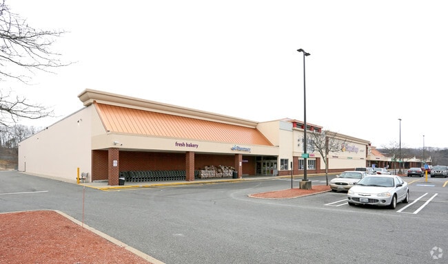

Property Detail
446 Putnam Pike
SMIT-000037-000000-000025
PROVIDENCE
Commercialbuilding
Rhode Island
PD
25
B and X Area of moderate flood hazard, usually the area between the limits of the 100-year and 500-year floods.
10.75 AC
2025
Smithfield
2025
Providence
012702
Providence-Warwick, RI-MA
78,346 SF
NEARBY LISTINGS FOR SALE OR LEASE
DEMOGRAPHICS near 446 Putnam Pike
1 mile
3 mile
5 mile
2025 Total Population
3,616
36,181
107,935
2030 Population
3,794
37,900
112,275
Pop Growth 2025-2030
+ 4.92%
+ 4.75%
+ 4.02%
Average Age
44
44
43
2025 Total Households
1,392
14,542
42,646
HH Growth 2025-2030
+ 5.03%
+ 4.81%
+ 4.14%
Median Household Inc
$103,701
$96,005
$90,345
Avg Household Size
2.50
2.40
2.40
2025 Avg HH Vehicles
2.00
2.00
2.00
Median Home Value
$416,667
$426,123
$392,045
Median Year Built
1970
1971
1969
Nearby Places
Map Layers
Map Styles
 Street
 Aerial
Layers
 Traffic
 Biking
Places
Listings with unknown addresses are not visible on the map
- Restaurants
- Banks
- Shops
- Fitness
- Groceries
PUBLIC TRANSPORTATION
COMMUTER RAIL
Providence (Providence/Stoughton Line - Massachusetts Bay Transportation Authority Commuter Rail (Purple Line))
Drive
Walk
Distance
Providence (Providence/Stoughton Line - Massachusetts Bay Transportation Authority Commuter Rail (Purple Line))
13 min
7.6 mi
Pawtucket/Central Falls (Foxboro Event Service - MBTA, Providence/Stoughton Line - MBTA)
Drive
Walk
Distance
Pawtucket/Central Falls (Foxboro Event Service - MBTA, Providence/Stoughton Line - MBTA)
13 min
8.1 mi
AIRPORT
Rhode Island Tf Green International
Drive
Walk
Distance
Rhode Island Tf Green International
24 min
15.1 mi
Freight Ports
Port of Davisville, RI
Drive
Walk
Distance
Port of Davisville, RI
35 min
24.3 mi
SALE & LEASE HISTORY
LISTING DATE
SALE/LEASE

Sep 10, 2019
For Lease
Aug 30, 2022
For Lease
Nearby Properties
Address
Land Use
TOTAL SIZE
Lot Size
Zoning
Address
Land Use
TOTAL SIZE
Lot Size
Zoning
89.07 AC
PD
Address
Land Use
TOTAL SIZE
Lot Size
Zoning
53.18 AC
C
Address
Land Use
TOTAL SIZE
Lot Size
Zoning
123.25 AC
R40
Address
Land Use
TOTAL SIZE
Lot Size
Zoning
1,792 SF
28.46 AC
Address
Land Use
TOTAL SIZE
Lot Size
Zoning
166,368 SF
10.74 AC
R20
Address
Land Use
TOTAL SIZE
Lot Size
Zoning
115,802 SF
10.30 AC
PC
Address
Land Use
TOTAL SIZE
Lot Size
Zoning
31.11 AC
R20M
Address
Land Use
TOTAL SIZE
Lot Size
Zoning
Address
Land Use
TOTAL SIZE
Lot Size
Zoning
185,010 SF
7.75 AC
MG
Address
Land Use
TOTAL SIZE
Lot Size
Zoning
56,451 SF
5 AC
C
Address
Land Use
TOTAL SIZE
Lot Size
Zoning
22,868 SF
12.22 AC
R20
Address
Land Use
TOTAL SIZE
Lot Size
Zoning
124,397 SF
13.66 AC
C
Address
Land Use
TOTAL SIZE
Lot Size
Zoning
89,788 SF
11.25 AC
R20
Address
Land Use
TOTAL SIZE
Lot Size
Zoning
72,531 SF
11.70 AC
R20
Address
Land Use
TOTAL SIZE
Lot Size
Zoning
9.59 AC
MU
Address
Land Use
TOTAL SIZE
Lot Size
Zoning
20 AC
R20M
Address
Land Use
TOTAL SIZE
Lot Size
Zoning
54,645 SF
13.40 AC
RMED
Address
Land Use
TOTAL SIZE
Lot Size
Zoning
102,497 SF
4.74 AC
RG
Address
Land Use
TOTAL SIZE
Lot Size
Zoning
87,649 SF
8 AC
R20
Address
Land Use
TOTAL SIZE
Lot Size
Zoning
162,087 SF
15.40 AC
PC
Address
Land Use
TOTAL SIZE
Lot Size
Zoning
85,130 SF
4.40 AC
R20
Address
Land Use
TOTAL SIZE
Lot Size
Zoning
44,381 SF
12.20 AC
R20
Address
Land Use
TOTAL SIZE
Lot Size
Zoning
96,723 SF
21.69 AC
PD
Address
Land Use
TOTAL SIZE
Lot Size
Zoning
88,147 SF
4.30 AC
CV
Address
Land Use
TOTAL SIZE
Lot Size
Zoning
1 AC
PD
Address
Land Use
TOTAL SIZE
Lot Size
Zoning
3.69 AC
C
Address
Land Use
TOTAL SIZE
Lot Size
Zoning
60,658 SF
11.40 AC
MU
Address
Land Use
TOTAL SIZE
Lot Size
Zoning
41,536 SF
25.80 AC
PC
Address
Land Use
TOTAL SIZE
Lot Size
Zoning
45,183 SF
9.75 AC
R80
The World's #1 Commercial Real Estate Marketplace
Connect with us
© 2026 CoStar Group
The information above has been obtained from sources believed reliable. While we do not doubt its accuracy we have not verified it and make no guarantee, warranty or representation about it. It is your responsibility to independently confirm its accuracy and completeness. Any projections, opinions, assumptions, or estimates used are for example only and do not represent the current or future performance of the property. The value of this transaction to you depends on tax and other factors which should be evaluated by your tax, financial, and legal advisors. You and your advisors should conduct a careful, independent investigation of the property to determine to your satisfaction the suitability of the property for your needs.