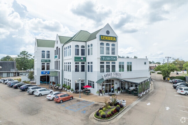
Property Record
4465 N I 55 N, Jackson, MS 39206

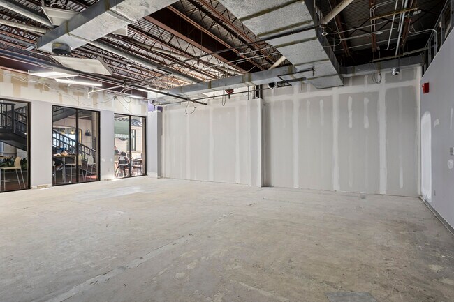

Current Lease Availabilities
Property Detail
4465 N I 55 N
Jackson, MS
BEG C/L CLOSED SPRUCE ST AT W/S NEW HWY 51 THENCE W 250 FT S 25 FT W 160.2 FT SW 65.4 FT SE 454.6 FT N/LY 336.9 FT TO BEG IN LOTS 7 & 8 TRAWICK EST SY LESS 0.3 AC E/S TO HWY
0437-0297-000
Hinds
Charitableorganization
Mississippi
B and X Area of moderate flood hazard, usually the area between the limits of the 100-year and 500-year floods.
7-8
2024
1 AC
2025
North Jackson
000500
Jackson
30,674 SF
NEARBY LISTINGS FOR SALE OR LEASE
DEMOGRAPHICS near 4465 N I 55 N
1 mile
3 mile
5 mile
2025 Total Population
8,037
45,480
98,585
2030 Population
7,650
43,403
96,739
Pop Growth 2025-2030
(4.82%)
(4.57%)
(1.87%)
Average Age
38
39
39
2025 Total Households
3,617
19,776
43,377
HH Growth 2025-2030
(5.11%)
(4.71%)
(1.93%)
Median Household Inc
$63,665
$53,729
$48,698
Avg Household Size
2.10
2.20
2.10
2025 Avg HH Vehicles
2.00
2.00
2.00
Median Home Value
$266,368
$181,461
$159,681
Median Year Built
1967
1967
1973
Nearby Places
Map Layers
Map Styles
 Street
 Aerial
Transit
 Traffic
 Biking
Places
Listings with unknown addresses are not visible on the map
- Restaurants
- Banks
- Shops
- Fitness
- Groceries
PUBLIC TRANSPORTATION
COMMUTER RAIL
Drive
Walk
Distance
9 min
5.6 mi
AIRPORT
Jackson-Medgar Wiley Evers International
Drive
Walk
Distance
Jackson-Medgar Wiley Evers International
21 min
11.3 mi
Nearby Properties
Address
Land Use
TOTAL SIZE
Lot Size
Zoning
Address
Land Use
TOTAL SIZE
Lot Size
Zoning
560,993 SF
47 AC
Address
Land Use
TOTAL SIZE
Lot Size
Zoning
48,134 SF
6.62 AC
Address
Land Use
TOTAL SIZE
Lot Size
Zoning
7,561 SF
153.82 AC
Address
Land Use
TOTAL SIZE
Lot Size
Zoning
206,400 SF
7.96 AC
Address
Land Use
TOTAL SIZE
Lot Size
Zoning
40,445 SF
3 AC
Address
Land Use
TOTAL SIZE
Lot Size
Zoning
51,260 SF
1 AC
Address
Land Use
TOTAL SIZE
Lot Size
Zoning
33,960 SF
19,602 AC
Address
Land Use
TOTAL SIZE
Lot Size
Zoning
236.80 AC
Address
Land Use
TOTAL SIZE
Lot Size
Zoning
17,261 SF
18.20 AC
Address
Land Use
TOTAL SIZE
Lot Size
Zoning
32,886 SF
1 AC
Address
Land Use
TOTAL SIZE
Lot Size
Zoning
59,840 SF
2.72 AC
Address
Land Use
TOTAL SIZE
Lot Size
Zoning
55,160 SF
3 AC
Address
Land Use
TOTAL SIZE
Lot Size
Zoning
31,541 SF
4 AC
Address
Land Use
TOTAL SIZE
Lot Size
Zoning
64,949 SF
3 AC
Address
Land Use
TOTAL SIZE
Lot Size
Zoning
54,291 SF
6.99 AC
Address
Land Use
TOTAL SIZE
Lot Size
Zoning
81,649 SF
5.60 AC
Address
Land Use
TOTAL SIZE
Lot Size
Zoning
102,249 SF
14.38 AC
Address
Land Use
TOTAL SIZE
Lot Size
Zoning
10,620 SF
2.81 AC
Address
Land Use
TOTAL SIZE
Lot Size
Zoning
5,354 SF
0.68 AC
Address
Land Use
TOTAL SIZE
Lot Size
Zoning
15,374 SF
0.64 AC
Address
Land Use
TOTAL SIZE
Lot Size
Zoning
230,401 SF
643,381.54 AC
Address
Land Use
TOTAL SIZE
Lot Size
Zoning
108,198 SF
15.40 AC
Address
Land Use
TOTAL SIZE
Lot Size
Zoning
4.38 AC
Address
Land Use
TOTAL SIZE
Lot Size
Zoning
20.54 AC
Address
Land Use
TOTAL SIZE
Lot Size
Zoning
23,589 SF
110,808.08 AC
Address
Land Use
TOTAL SIZE
Lot Size
Zoning
73,795 SF
5.02 AC
Address
Land Use
TOTAL SIZE
Lot Size
Zoning
29,399 SF
1.04 AC
Address
Land Use
TOTAL SIZE
Lot Size
Zoning
93.67 AC
Address
Land Use
TOTAL SIZE
Lot Size
Zoning
78,239 SF
4 AC
Address
Land Use
TOTAL SIZE
Lot Size
Zoning
9,003 SF
1 AC
The World's #1 Commercial Real Estate Marketplace
Connect with us
© 2026 CoStar Group
The information above has been obtained from sources believed reliable. While we do not doubt its accuracy we have not verified it and make no guarantee, warranty or representation about it. It is your responsibility to independently confirm its accuracy and completeness. Any projections, opinions, assumptions, or estimates used are for example only and do not represent the current or future performance of the property. The value of this transaction to you depends on tax and other factors which should be evaluated by your tax, financial, and legal advisors. You and your advisors should conduct a careful, independent investigation of the property to determine to your satisfaction the suitability of the property for your needs.