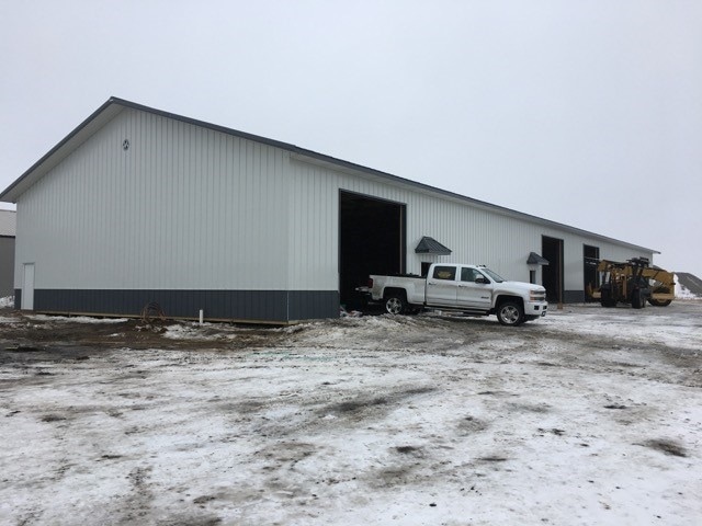
Property Record
4468 27Th St N, Fargo, ND 58102


NEARBY LISTINGS FOR SALE OR LEASE
Property Detail
4468 27Th St N
Fargo, ND-MN
Vision
01-5910-01900-000
LOT: 9 BLOCK: 2 ADDITION: JERSTAD-THOMPSON FIRST SUBDIVISION ADDITIONAL: JERSTAD-THOMPSON 1ST SUB LT 9 BLK 2 **11/1/99
Realpropertynec
Cass
AE
North Dakota
38017C0579G
9
2024
0.71 AC
2024
Fargo
000300
Other Market Areas
DEMOGRAPHICS near 4468 27Th St N
1 Mile
3 Mile
5 Mile
2024 Total Population
63
14,241
49,571
2029 Population
67
15,092
52,570
Pop Growth 2024-2029
+ 6.35%
+ 5.98%
+ 6.05%
Average Age
41
39
37
2024 Total Households
21
5,945
20,832
HH Growth 2024-2029
+ 9.52%
+ 7.22%
+ 7.38%
Median Household Inc
$139,999
$63,055
$49,935
Avg Household Size
2.80
2.10
2.00
2024 Avg HH Vehicles
2.00
2.00
2.00
Median Home Value
$399,999
$253,959
$225,491
Median Year Built
1993
1976
1972
Nearby Places
Map Layers
Map Styles
 Street
 Aerial
- Restaurants
- Banks
- Shops
- Fitness
- Groceries
PUBLIC TRANSPORTATION
COMMUTER RAIL
Fargo Amtrak Station (Empire Builder - Amtrak)
DRIVE
WALK
Distance
Fargo Amtrak Station (Empire Builder - Amtrak)
12 min
5.7 mi
AIRPORT
Hector International
DRIVE
WALK
Distance
Hector International
7 min
3.1 mi
Freight Ports
Port Milwaukee
DRIVE
WALK
Distance
Port Milwaukee
639 min
578.9 mi
SALE & LEASE HISTORY
LISTING DATE
SALE/LEASE

Mar 03, 2017
For Lease
Jun 30, 2020
For Lease
Jul 25, 2019
For Lease
Aug 21, 2025
For Lease
Nearby Properties
Address
Land Use
TOTAL SIZE
Lot Size
Zoning
Address
Land Use
TOTAL SIZE
Lot Size
Zoning
Address
Land Use
TOTAL SIZE
Lot Size
Zoning
12.07 AC
Address
Land Use
TOTAL SIZE
Lot Size
Zoning
3.31 AC
Address
Land Use
TOTAL SIZE
Lot Size
Zoning
242,032 SF
14.23 AC
GI
Address
Land Use
TOTAL SIZE
Lot Size
Zoning
Address
Land Use
TOTAL SIZE
Lot Size
Zoning
60,125 SF
25.37 AC
LI
Address
Land Use
TOTAL SIZE
Lot Size
Zoning
10.68 AC
Address
Land Use
TOTAL SIZE
Lot Size
Zoning
Address
Land Use
TOTAL SIZE
Lot Size
Zoning
11.79 AC
Address
Land Use
TOTAL SIZE
Lot Size
Zoning
Address
Land Use
TOTAL SIZE
Lot Size
Zoning
247,888 SF
15.13 AC
GI
Address
Land Use
TOTAL SIZE
Lot Size
Zoning
Address
Land Use
TOTAL SIZE
Lot Size
Zoning
3.59 AC
GI
Address
Land Use
TOTAL SIZE
Lot Size
Zoning
286,296 SF
18.30 AC
LI
Address
Land Use
TOTAL SIZE
Lot Size
Zoning
219,000 SF
11.79 AC
GI
Address
Land Use
TOTAL SIZE
Lot Size
Zoning
62,442 SF
1.54 AC
LC
Address
Land Use
TOTAL SIZE
Lot Size
Zoning
28,904 SF
0.08 AC
LC
Address
Land Use
TOTAL SIZE
Lot Size
Zoning
10.10 AC
GI
Address
Land Use
TOTAL SIZE
Lot Size
Zoning
Address
Land Use
TOTAL SIZE
Lot Size
Zoning
33,030 SF
1.29 AC
MR3
Address
Land Use
TOTAL SIZE
Lot Size
Zoning
Address
Land Use
TOTAL SIZE
Lot Size
Zoning
37.05 AC
MHP
Address
Land Use
TOTAL SIZE
Lot Size
Zoning
100,800 SF
5.32 AC
GI
Address
Land Use
TOTAL SIZE
Lot Size
Zoning
Address
Land Use
TOTAL SIZE
Lot Size
Zoning
42,157 SF
2.55 AC
PI
Address
Land Use
TOTAL SIZE
Lot Size
Zoning
42,154 SF
6.63 AC
PI
Address
Land Use
TOTAL SIZE
Lot Size
Zoning
25.66 AC
Address
Land Use
TOTAL SIZE
Lot Size
Zoning
9.92 AC
AG
Address
Land Use
TOTAL SIZE
Lot Size
Zoning
94,889 SF
2.29 AC
MR3
Address
Land Use
TOTAL SIZE
Lot Size
Zoning
The World's #1 Commercial Real Estate Marketplace
Connect with us
© 2025 CoStar Group
The information above has been obtained from sources believed reliable. While we do not doubt its accuracy we have not verified it and make no guarantee, warranty or representation about it. It is your responsibility to independently confirm its accuracy and completeness. Any projections, opinions, assumptions, or estimates used are for example only and do not represent the current or future performance of the property. The value of this transaction to you depends on tax and other factors which should be evaluated by your tax, financial, and legal advisors. You and your advisors should conduct a careful, independent investigation of the property to determine to your satisfaction the suitability of the property for your needs.