Property Record
4468 Glenwood Rd, Decatur, GA 30032

This Property Is For Sale
NEARBY LISTINGS FOR SALE OR LEASE
Property Detail
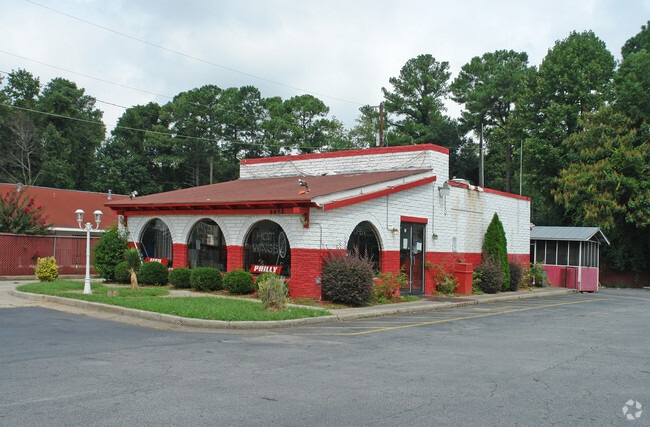
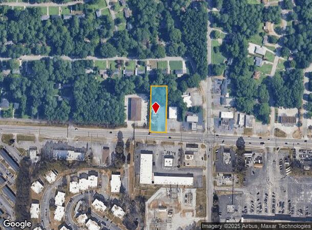
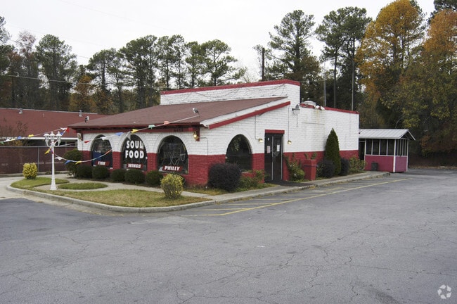
4468 Glenwood Rd
15-188-04-015
BEG AT THE NW INTERSECT OF AUSTIN DR GLENWOOD RD
Restaurantbuilding
DeKalb
X
Georgia
13089C0151J
15
2025
0.63 AC
2025
Decatur/East Atl
023108
Atlanta
1,288 SF
Atlanta-Sandy Springs-Roswell, GA
DEMOGRAPHICS near 4468 Glenwood Rd
1 Mile
3 Mile
5 Mile
2024 Total Population
10,727
88,211
262,220
2029 Population
10,803
88,328
261,762
Pop Growth 2024-2029
+ 0.71%
+ 0.13%
(0.17%)
Average Age
40
41
39
2024 Total Households
4,020
34,531
101,455
HH Growth 2024-2029
+ 0.72%
+ 0.30%
(0.07%)
Median Household Inc
$49,734
$50,649
$60,531
Avg Household Size
2.50
2.40
2.50
2024 Avg HH Vehicles
1.00
2.00
2.00
Median Home Value
$173,645
$213,708
$242,868
Median Year Built
1969
1974
1978
Nearby Places
Map Layers
Map Styles
 Street
 Aerial
- Restaurants
- Banks
- Shops
- Fitness
- Groceries
PUBLIC TRANSPORTATION
AIRPORT
Hartsfield - Jackson Atlanta International
DRIVE
WALK
Distance
Hartsfield - Jackson Atlanta International
24 min
15.4 mi
Nearby Properties
Address
Land Use
TOTAL SIZE
Lot Size
Zoning
Address
Land Use
TOTAL SIZE
Lot Size
Zoning
78,008 SF
11.16 AC
HR-3
Address
Land Use
TOTAL SIZE
Lot Size
Zoning
988,394 SF
102.84 AC
RM100
Address
Land Use
TOTAL SIZE
Lot Size
Zoning
287,674 SF
17.63 AC
R75: SF RE
Address
Land Use
TOTAL SIZE
Lot Size
Zoning
350,556 SF
46.09 AC
X
Address
Land Use
TOTAL SIZE
Lot Size
Zoning
455,599 SF
43.15 AC
HR-3
Address
Land Use
TOTAL SIZE
Lot Size
Zoning
295,718 SF
25.64 AC
RM85
Address
Land Use
TOTAL SIZE
Lot Size
Zoning
76,500 SF
2.84 AC
X
Address
Land Use
TOTAL SIZE
Lot Size
Zoning
76,654 SF
3.14 AC
C-1
Address
Land Use
TOTAL SIZE
Lot Size
Zoning
91,622 SF
18.99 AC
X
Address
Land Use
TOTAL SIZE
Lot Size
Zoning
522,850 SF
41.34 AC
RM75
Address
Land Use
TOTAL SIZE
Lot Size
Zoning
251,327 SF
19.92 AC
X
Address
Land Use
TOTAL SIZE
Lot Size
Zoning
396,905 SF
20.82 AC
RM85
Address
Land Use
TOTAL SIZE
Lot Size
Zoning
71,208 SF
15 AC
X
Address
Land Use
TOTAL SIZE
Lot Size
Zoning
245,053 SF
22.77 AC
RM85
Address
Land Use
TOTAL SIZE
Lot Size
Zoning
292,395 SF
19.65 AC
RM100
Address
Land Use
TOTAL SIZE
Lot Size
Zoning
253,740 SF
13.33 AC
RM75
Address
Land Use
TOTAL SIZE
Lot Size
Zoning
158,939 SF
14.09 AC
RM85
Address
Land Use
TOTAL SIZE
Lot Size
Zoning
13,114 SF
17.54 AC
RM100
Address
Land Use
TOTAL SIZE
Lot Size
Zoning
256,445 SF
11.71 AC
RM85
Address
Land Use
TOTAL SIZE
Lot Size
Zoning
209,022 SF
16.22 AC
RM100
Address
Land Use
TOTAL SIZE
Lot Size
Zoning
249,668 SF
16.76 AC
RM100
Address
Land Use
TOTAL SIZE
Lot Size
Zoning
235,787 SF
15.43 AC
RM100
Address
Land Use
TOTAL SIZE
Lot Size
Zoning
221,594 SF
15.90 AC
RM85
Address
Land Use
TOTAL SIZE
Lot Size
Zoning
419,434 SF
21.59 AC
RM85
Address
Land Use
TOTAL SIZE
Lot Size
Zoning
23,072 SF
5.48 AC
C1
Address
Land Use
TOTAL SIZE
Lot Size
Zoning
118,371 SF
15 AC
R75
Address
Land Use
TOTAL SIZE
Lot Size
Zoning
300,697 SF
21.18 AC
RM85
Address
Land Use
TOTAL SIZE
Lot Size
Zoning
132,604 SF
19.12 AC
RM100
Address
Land Use
TOTAL SIZE
Lot Size
Zoning
277,816 SF
18.15 AC
RM100
Address
Land Use
TOTAL SIZE
Lot Size
Zoning
183,598 SF
18.88 AC
X
The World's #1 Commercial Real Estate Marketplace
Connect with us
© 2025 CoStar Group
The information above has been obtained from sources believed reliable. While we do not doubt its accuracy we have not verified it and make no guarantee, warranty or representation about it. It is your responsibility to independently confirm its accuracy and completeness. Any projections, opinions, assumptions, or estimates used are for example only and do not represent the current or future performance of the property. The value of this transaction to you depends on tax and other factors which should be evaluated by your tax, financial, and legal advisors. You and your advisors should conduct a careful, independent investigation of the property to determine to your satisfaction the suitability of the property for your needs.