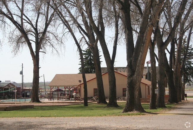
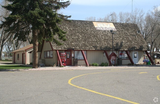
Property Record
4469 E Us Highway 34, Loveland, CO 80537

NEARBY LISTINGS FOR SALE OR LEASE
Property Detail
4469 E Us Highway 34
85090-00-008
Thompson River Ranch Filing #1
Commercialbuilding
BEG AT PT WH BEARS N 1 21 E 50 FT, N 88 25 W 240 FT FROM S 1/4 COR 9-5-68, N 1 21 E 217.6 FT, N 88 25 W 100 FT, S 1 21 W 217.6 FT TO PT ON N R/W HWY 34, S 88 25 E 100 FT TO BEG; LESS 0.12 AC HWY; ALSO BEG AT PT ON NRLY R/W HWY 34 WH S 1/4 COR 9-5-68
X
Larimer
08069C1200F
Colorado
2024
0.32 AC
2025
Fort Collins/Loveland
001715
Denver
4,539 SF
Fort Collins-Loveland, CO
DEMOGRAPHICS near 4469 E Us Highway 34
1 mile
3 mile
5 mile
2024 Total Population
4,823
28,712
79,617
2029 Population
5,261
30,691
85,501
Pop Growth 2024-2029
+ 9.08%
+ 6.89%
+ 7.39%
Average Age
39
40
41
2024 Total Households
2,230
11,993
32,895
HH Growth 2024-2029
+ 9.01%
+ 7.17%
+ 7.36%
Median Household Inc
$95,074
$86,374
$82,432
Avg Household Size
2.20
2.40
2.40
2024 Avg HH Vehicles
2.00
2.00
2.00
Median Home Value
$518,555
$469,591
$459,002
Median Year Built
2010
2006
1995
Nearby Places
Map Layers
Map Styles
 Street
 Aerial
Transit
 Traffic
 Biking
Places
Listings with unknown addresses are not visible on the map
- Restaurants
- Banks
- Shops
- Fitness
- Groceries
Nearby Properties
Address
Land Use
TOTAL SIZE
Lot Size
Zoning
Address
Land Use
TOTAL SIZE
Lot Size
Zoning
689,698 SF
112.68 AC
P59
Address
Land Use
TOTAL SIZE
Lot Size
Zoning
444,114 SF
73.02 AC
Address
Land Use
TOTAL SIZE
Lot Size
Zoning
218,000 SF
45.72 AC
R1
Address
Land Use
TOTAL SIZE
Lot Size
Zoning
316,352 SF
42.97 AC
I
Address
Land Use
TOTAL SIZE
Lot Size
Zoning
366,684 SF
29.44 AC
R3
Address
Land Use
TOTAL SIZE
Lot Size
Zoning
99,085 SF
206.52 AC
P74
Address
Land Use
TOTAL SIZE
Lot Size
Zoning
1,149,762 SF
172.22 AC
I
Address
Land Use
TOTAL SIZE
Lot Size
Zoning
231,071 SF
23.80 AC
P12
Address
Land Use
TOTAL SIZE
Lot Size
Zoning
109,639 SF
8.49 AC
B
Address
Land Use
TOTAL SIZE
Lot Size
Zoning
307,636 SF
Address
Land Use
TOTAL SIZE
Lot Size
Zoning
259,121 SF
15.93 AC
Address
Land Use
TOTAL SIZE
Lot Size
Zoning
120,688 SF
1.24 AC
Address
Land Use
TOTAL SIZE
Lot Size
Zoning
197,850 SF
35.83 AC
B
Address
Land Use
TOTAL SIZE
Lot Size
Zoning
84,548 SF
4.91 AC
P12
Address
Land Use
TOTAL SIZE
Lot Size
Zoning
96,723 SF
9.16 AC
I
Address
Land Use
TOTAL SIZE
Lot Size
Zoning
35,554 SF
7.69 AC
Address
Land Use
TOTAL SIZE
Lot Size
Zoning
80,042 SF
13.82 AC
Address
Land Use
TOTAL SIZE
Lot Size
Zoning
137,225 SF
25.76 AC
R1
Address
Land Use
TOTAL SIZE
Lot Size
Zoning
63,350 SF
10.86 AC
Address
Land Use
TOTAL SIZE
Lot Size
Zoning
222,973 SF
3.35 AC
Address
Land Use
TOTAL SIZE
Lot Size
Zoning
205,804 SF
21.91 AC
P51
Address
Land Use
TOTAL SIZE
Lot Size
Zoning
81,664 SF
0.95 AC
Address
Land Use
TOTAL SIZE
Lot Size
Zoning
427,136 SF
10.48 AC
Address
Land Use
TOTAL SIZE
Lot Size
Zoning
326,329 SF
11.57 AC
Address
Land Use
TOTAL SIZE
Lot Size
Zoning
115,778 SF
27.67 AC
I
Address
Land Use
TOTAL SIZE
Lot Size
Zoning
286,421 SF
8.52 AC
Address
Land Use
TOTAL SIZE
Lot Size
Zoning
64,309 SF
14.54 AC
Address
Land Use
TOTAL SIZE
Lot Size
Zoning
144,784 SF
7.32 AC
Address
Land Use
TOTAL SIZE
Lot Size
Zoning
122,597 SF
7.45 AC
Address
Land Use
TOTAL SIZE
Lot Size
Zoning
122,597 SF
6.77 AC
The World's #1 Commercial Real Estate Marketplace
Connect with us
© 2026 CoStar Group
The information above has been obtained from sources believed reliable. While we do not doubt its accuracy we have not verified it and make no guarantee, warranty or representation about it. It is your responsibility to independently confirm its accuracy and completeness. Any projections, opinions, assumptions, or estimates used are for example only and do not represent the current or future performance of the property. The value of this transaction to you depends on tax and other factors which should be evaluated by your tax, financial, and legal advisors. You and your advisors should conduct a careful, independent investigation of the property to determine to your satisfaction the suitability of the property for your needs.