Property Record
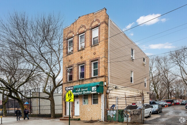
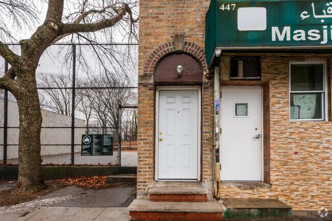
447 Jackson Ave, Bronx, NY 10455


This Property Is For Sale
NEARBY LISTINGS FOR SALE OR LEASE
Property Detail
447 Jackson Ave
02557-0061
Map Wilton Port Morris
Commercialofficeresidentialmixeduse
Bronx
X
New York
3604970091F
61
2024
0.08 AC
2025
Bronx
007300
Westchester/So Connecticut
3,087 SF
New York-Jersey City-White Plains, NY-NJ
DEMOGRAPHICS near 447 Jackson Ave
1 mile
3 mile
5 mile
2024 Total Population
126,771
1,146,094
2,740,904
2029 Population
118,083
1,064,021
2,553,735
Pop Growth 2024-2029
(6.85%)
(7.16%)
(6.83%)
Average Age
36
38
40
2024 Total Households
44,204
431,716
1,088,216
HH Growth 2024-2029
(7.64%)
(7.69%)
(7.15%)
Median Household Inc
$28,871
$42,242
$60,282
Avg Household Size
2.70
2.50
2.40
2024 Avg HH Vehicles
.00
.00
.00
Median Home Value
$397,411
$688,572
$754,411
Median Year Built
1967
1954
1952
Nearby Places
Map Layers
Map Styles
 Street
 Aerial
Transit
 Traffic
 Biking
Places
Listings with unknown addresses are not visible on the map
- Restaurants
- Banks
- Shops
- Fitness
- Groceries
PUBLIC TRANSPORTATION
TRANSIT/SUBWAY
East 143 Street-St Marys Street (6 - New York MTA Subway (The Subway))
Drive
Walk
Distance
East 143 Street-St Marys Street (6 - New York MTA Subway (The Subway))
1 min
5 min
0.3 mi
East 149 Street (6 - New York MTA Subway (The Subway))
Drive
Walk
Distance
East 149 Street (6 - New York MTA Subway (The Subway))
1 min
7 min
0.4 mi
Jackson Avenue (2 - New York MTA Subway (The Subway), 5 - New York MTA Subway (The Subway))
Drive
Walk
Distance
Jackson Avenue (2 - New York MTA Subway (The Subway), 5 - New York MTA Subway (The Subway))
2 min
8 min
0.4 mi
Cypress Avenue (6 - New York MTA Subway (The Subway))
Drive
Walk
Distance
Cypress Avenue (6 - New York MTA Subway (The Subway))
2 min
9 min
0.5 mi
Brook Avenue (6 - New York MTA Subway (The Subway))
Drive
Walk
Distance
Brook Avenue (6 - New York MTA Subway (The Subway))
3 min
14 min
0.8 mi
COMMUTER RAIL
Melrose Station (Harlem Line - Metro-North Commuter Railroad Company (Metro-North))
Drive
Walk
Distance
Melrose Station (Harlem Line - Metro-North Commuter Railroad Company (Metro-North))
7 min
2.0 mi
Yankees-E 153Rd Street Station (Hudson Line - Metro-North Commuter Railroad Company (Metro-North))
Drive
Walk
Distance
Yankees-E 153Rd Street Station (Hudson Line - Metro-North Commuter Railroad Company (Metro-North))
4 min
2.8 mi
AIRPORT
LaGuardia
Drive
Walk
Distance
LaGuardia
14 min
6.5 mi
John F Kennedy International
Drive
Walk
Distance
John F Kennedy International
27 min
17.7 mi
Newark Liberty International
Drive
Walk
Distance
Newark Liberty International
31 min
25.1 mi
Freight Ports
NY - Red Hook Container Terminal
Drive
Walk
Distance
NY - Red Hook Container Terminal
26 min
14.7 mi
Nearby Properties
Address
Land Use
TOTAL SIZE
Lot Size
Zoning
Address
Land Use
TOTAL SIZE
Lot Size
Zoning
5,519,372 SF
409.21 AC
C8-2
Address
Land Use
TOTAL SIZE
Lot Size
Zoning
3,693,539 SF
8.37 AC
R8
Address
Land Use
TOTAL SIZE
Lot Size
Zoning
400,160 SF
10.96 AC
R7-2
Address
Land Use
TOTAL SIZE
Lot Size
Zoning
2,215,000 SF
6.43 AC
R9
Address
Land Use
TOTAL SIZE
Lot Size
Zoning
1,368,870 SF
16.86 AC
R8
Address
Land Use
TOTAL SIZE
Lot Size
Zoning
2,278,432 SF
5.99 AC
R7-2
Address
Land Use
TOTAL SIZE
Lot Size
Zoning
755,000 SF
1.85 AC
R7-2
Address
Land Use
TOTAL SIZE
Lot Size
Zoning
11.92 AC
R7-2
Address
Land Use
TOTAL SIZE
Lot Size
Zoning
11.92 AC
R7-2
Address
Land Use
TOTAL SIZE
Lot Size
Zoning
11.92 AC
R7-2
Address
Land Use
TOTAL SIZE
Lot Size
Zoning
11.92 AC
R7-2
Address
Land Use
TOTAL SIZE
Lot Size
Zoning
11.92 AC
R7-2
Address
Land Use
TOTAL SIZE
Lot Size
Zoning
11.92 AC
R7-2
Address
Land Use
TOTAL SIZE
Lot Size
Zoning
11.92 AC
R7-2
Address
Land Use
TOTAL SIZE
Lot Size
Zoning
11.92 AC
R7-2
Address
Land Use
TOTAL SIZE
Lot Size
Zoning
11.92 AC
R7-2
Address
Land Use
TOTAL SIZE
Lot Size
Zoning
11.92 AC
R7-2
Address
Land Use
TOTAL SIZE
Lot Size
Zoning
11.92 AC
R7-2
Address
Land Use
TOTAL SIZE
Lot Size
Zoning
11.92 AC
R7-2
Address
Land Use
TOTAL SIZE
Lot Size
Zoning
11.92 AC
R7-2
Address
Land Use
TOTAL SIZE
Lot Size
Zoning
11.92 AC
R7-2
Address
Land Use
TOTAL SIZE
Lot Size
Zoning
11.92 AC
R7-2
Address
Land Use
TOTAL SIZE
Lot Size
Zoning
11.92 AC
R7-2
Address
Land Use
TOTAL SIZE
Lot Size
Zoning
11.92 AC
R7-2
Address
Land Use
TOTAL SIZE
Lot Size
Zoning
11.92 AC
R7-2
Address
Land Use
TOTAL SIZE
Lot Size
Zoning
11.92 AC
R7-2
Address
Land Use
TOTAL SIZE
Lot Size
Zoning
11.92 AC
R7-2
Address
Land Use
TOTAL SIZE
Lot Size
Zoning
11.92 AC
R7-2
Address
Land Use
TOTAL SIZE
Lot Size
Zoning
11.92 AC
R7-2
Address
Land Use
TOTAL SIZE
Lot Size
Zoning
11.92 AC
R7-2
The World's #1 Commercial Real Estate Marketplace
Connect with us
© 2026 CoStar Group
The information above has been obtained from sources believed reliable. While we do not doubt its accuracy we have not verified it and make no guarantee, warranty or representation about it. It is your responsibility to independently confirm its accuracy and completeness. Any projections, opinions, assumptions, or estimates used are for example only and do not represent the current or future performance of the property. The value of this transaction to you depends on tax and other factors which should be evaluated by your tax, financial, and legal advisors. You and your advisors should conduct a careful, independent investigation of the property to determine to your satisfaction the suitability of the property for your needs.