Property Record
447 E Walnut St, Wauseon, OH 43567

Save to a Folder
{{folder.Name}}
{{folder.ListingIds.length}} Properties
{{folder.ListingIds.length}} Property
Create a New Folder
Property Detail
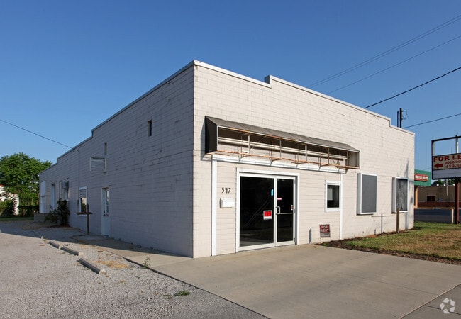
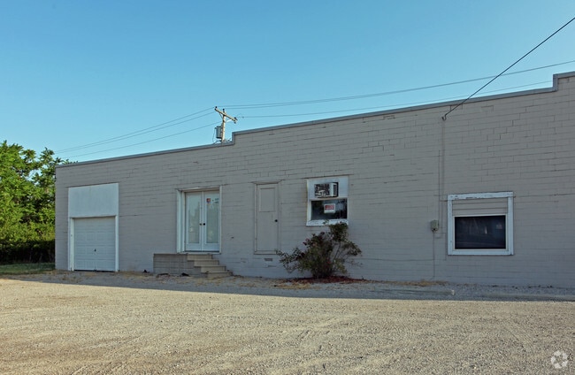
447 E Walnut St
06-015972-00.000
6E-7N-23 PT NE PT PAR 18 65FT 173 FT OL A .85A
Industrialgeneral
Fulton
B and X Area of moderate flood hazard, usually the area between the limits of the 100-year and 500-year floods.
Ohio
2025
0.85 AC
2025
Fulton County
040702
Toledo
12,400 SF
Toledo, OH
NEARBY LISTINGS FOR SALE OR LEASE
DEMOGRAPHICS near 447 E Walnut St
1 mile
3 mile
5 mile
2025 Total Population
5,436
9,213
11,460
2030 Population
5,395
9,152
11,369
Pop Growth 2025-2030
(0.75%)
(0.66%)
(0.79%)
Average Age
39
40
41
2025 Total Households
2,202
3,695
4,554
HH Growth 2025-2030
(0.77%)
(0.68%)
(0.77%)
Median Household Inc
$68,870
$72,687
$75,056
Avg Household Size
2.40
2.40
2.40
2025 Avg HH Vehicles
2.00
2.00
2.00
Median Home Value
$181,847
$188,161
$196,462
Median Year Built
1969
1973
1973
Nearby Places
Map Layers
Map Styles
 Street
 Aerial
Layers
 Traffic
 Biking
Places
Listings with unknown addresses are not visible on the map
- Restaurants
- Banks
- Shops
- Fitness
- Groceries
PUBLIC TRANSPORTATION
AIRPORT
Eugene F Kranz Toledo Express
Drive
Walk
Distance
Eugene F Kranz Toledo Express
37 min
19.7 mi
Freight Ports
Port of Toledo
Drive
Walk
Distance
Port of Toledo
63 min
43.8 mi
Nearby Properties
Address
Land Use
TOTAL SIZE
Lot Size
Zoning
Address
Land Use
TOTAL SIZE
Lot Size
Zoning
13,763 SF
8.32 AC
R4
Address
Land Use
TOTAL SIZE
Lot Size
Zoning
137,265 SF
40 AC
R1
Address
Land Use
TOTAL SIZE
Lot Size
Zoning
170,800 SF
39.10 AC
M2
Address
Land Use
TOTAL SIZE
Lot Size
Zoning
26,372 SF
43.86 AC
R1
Address
Land Use
TOTAL SIZE
Lot Size
Zoning
215,270 SF
23.63 AC
B2
Address
Land Use
TOTAL SIZE
Lot Size
Zoning
71,038 SF
20 AC
R2
Address
Land Use
TOTAL SIZE
Lot Size
Zoning
25,036 SF
11.40 AC
Address
Land Use
TOTAL SIZE
Lot Size
Zoning
36,080 SF
17.32 AC
Address
Land Use
TOTAL SIZE
Lot Size
Zoning
21,736 SF
6.50 AC
Address
Land Use
TOTAL SIZE
Lot Size
Zoning
7.92 AC
Address
Land Use
TOTAL SIZE
Lot Size
Zoning
12,940 SF
3.62 AC
R1
Address
Land Use
TOTAL SIZE
Lot Size
Zoning
9,772 SF
8.48 AC
R4
Address
Land Use
TOTAL SIZE
Lot Size
Zoning
6,000 SF
224.49 AC
R2
Address
Land Use
TOTAL SIZE
Lot Size
Zoning
99,800 SF
3.30 AC
M2
Address
Land Use
TOTAL SIZE
Lot Size
Zoning
5.47 AC
Address
Land Use
TOTAL SIZE
Lot Size
Zoning
19,516 SF
1.21 AC
B3
Address
Land Use
TOTAL SIZE
Lot Size
Zoning
13,636 SF
1.93 AC
Address
Land Use
TOTAL SIZE
Lot Size
Zoning
12,084 SF
0.08 AC
Address
Land Use
TOTAL SIZE
Lot Size
Zoning
9,627 SF
11.49 AC
B4
Address
Land Use
TOTAL SIZE
Lot Size
Zoning
1,632 SF
7.43 AC
R4
Address
Land Use
TOTAL SIZE
Lot Size
Zoning
8,063 SF
2.10 AC
B3
Address
Land Use
TOTAL SIZE
Lot Size
Zoning
58,392 SF
5.96 AC
B2
Address
Land Use
TOTAL SIZE
Lot Size
Zoning
1,404 SF
28.98 AC
Address
Land Use
TOTAL SIZE
Lot Size
Zoning
1,636 SF
436.60 AC
Address
Land Use
TOTAL SIZE
Lot Size
Zoning
655 SF
8.18 AC
Address
Land Use
TOTAL SIZE
Lot Size
Zoning
12,000 SF
3.49 AC
M2
Address
Land Use
TOTAL SIZE
Lot Size
Zoning
2,144 SF
230 AC
Address
Land Use
TOTAL SIZE
Lot Size
Zoning
2,880 SF
6.70 AC
M2
Address
Land Use
TOTAL SIZE
Lot Size
Zoning
11,810 SF
1.64 AC
B1
Address
Land Use
TOTAL SIZE
Lot Size
Zoning
3,456 SF
5 AC
R4
The World's #1 Commercial Real Estate Marketplace
Connect with us
© 2026 CoStar Group
The information above has been obtained from sources believed reliable. While we do not doubt its accuracy we have not verified it and make no guarantee, warranty or representation about it. It is your responsibility to independently confirm its accuracy and completeness. Any projections, opinions, assumptions, or estimates used are for example only and do not represent the current or future performance of the property. The value of this transaction to you depends on tax and other factors which should be evaluated by your tax, financial, and legal advisors. You and your advisors should conduct a careful, independent investigation of the property to determine to your satisfaction the suitability of the property for your needs.