No Photo
Property Record
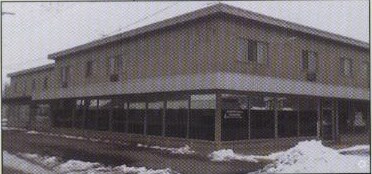
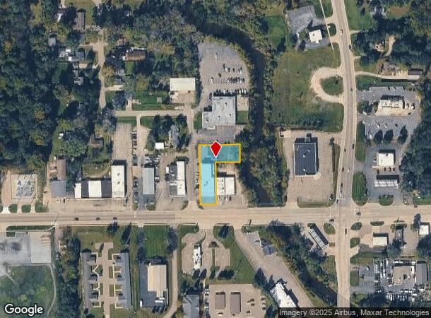
4475 Richfield Rd, Flint, MI 48506
NEARBY LISTINGS FOR SALE OR LEASE
-
-
View all Flint listings for sale on LoopNet.com
Property Detail
4475 Richfield Rd
Flint, MI
Kearsley Creek Subdivision
11-34-577-056
W 60 FT OF LOTS 34 & 35 & 36 & N 10 FT OF E 100 FT OF W 160 FT OF LOT 36 & W 160 FT OF LOT 37 KEARSLEY CREEK SUBDIVISION (16)
Commercialnec
Genesee
AE
Michigan
26049C0211D
34-37
2024
0.49 AC
2025
Northeast Flint/Genesee
012006
Detroit
13,775 SF
DEMOGRAPHICS near 4475 Richfield Rd
1 Mile
3 Mile
5 Mile
2024 Total Population
3,784
34,413
101,720
2029 Population
3,608
34,373
103,752
Pop Growth 2024-2029
(4.65%)
(0.12%)
+ 2.00%
Average Age
44
40
40
2024 Total Households
1,632
13,908
42,559
HH Growth 2024-2029
(4.72%)
(0.37%)
+ 1.93%
Median Household Inc
$55,386
$44,597
$40,835
Avg Household Size
2.30
2.40
2.30
2024 Avg HH Vehicles
2.00
2.00
1.00
Median Home Value
$142,009
$108,430
$97,842
Median Year Built
1958
1958
1963
Nearby Places
Map Layers
Map Styles
 Street
 Aerial
- Restaurants
- Banks
- Shops
- Fitness
- Groceries
PUBLIC TRANSPORTATION
COMMUTER RAIL
Flint Amtrak Station (Blue Water - Amtrak)
DRIVE
WALK
Distance
Flint Amtrak Station (Blue Water - Amtrak)
10 min
5.0 mi
AIRPORT
Bishop International
DRIVE
WALK
Distance
Bishop International
29 min
14.6 mi
Freight Ports
Port of Toledo
DRIVE
WALK
Distance
Port of Toledo
144 min
120.4 mi
Nearby Properties
Address
Land Use
TOTAL SIZE
Lot Size
Zoning
Address
Land Use
TOTAL SIZE
Lot Size
Zoning
MOBILE
Address
Land Use
TOTAL SIZE
Lot Size
Zoning
290,267 SF
79 AC
PC
Address
Land Use
TOTAL SIZE
Lot Size
Zoning
227,669 SF
25.87 AC
C-2
Address
Land Use
TOTAL SIZE
Lot Size
Zoning
354,079 SF
48.41 AC
C-4
Address
Land Use
TOTAL SIZE
Lot Size
Zoning
371,636 SF
12.50 AC
M-1
Address
Land Use
TOTAL SIZE
Lot Size
Zoning
2,400 SF
81 AC
R-4 MANUF
Address
Land Use
TOTAL SIZE
Lot Size
Zoning
111,882 SF
5.36 AC
C-4
Address
Land Use
TOTAL SIZE
Lot Size
Zoning
419,038 SF
57.18 AC
M-2
Address
Land Use
TOTAL SIZE
Lot Size
Zoning
136,506 SF
16.54 AC
C-4
Address
Land Use
TOTAL SIZE
Lot Size
Zoning
Address
Land Use
TOTAL SIZE
Lot Size
Zoning
218,229 SF
37.64 AC
CE
Address
Land Use
TOTAL SIZE
Lot Size
Zoning
107,580 SF
5.18 AC
RETAIL
Address
Land Use
TOTAL SIZE
Lot Size
Zoning
82,240 SF
15.03 AC
C-2
Address
Land Use
TOTAL SIZE
Lot Size
Zoning
192,900 SF
6.50 AC
CE
Address
Land Use
TOTAL SIZE
Lot Size
Zoning
118,210 SF
6.60 AC
CE
Address
Land Use
TOTAL SIZE
Lot Size
Zoning
173,312 SF
23.49 AC
CE
Address
Land Use
TOTAL SIZE
Lot Size
Zoning
72,720 SF
6.41 AC
C-2
Address
Land Use
TOTAL SIZE
Lot Size
Zoning
726 SF
10.40 AC
R-4 MANUF
Address
Land Use
TOTAL SIZE
Lot Size
Zoning
19,744 SF
3.52 AC
C-2
Address
Land Use
TOTAL SIZE
Lot Size
Zoning
58,197 SF
11.90 AC
C-2
Address
Land Use
TOTAL SIZE
Lot Size
Zoning
43,751 SF
3.14 AC
TN-2
Address
Land Use
TOTAL SIZE
Lot Size
Zoning
48,411 SF
16.05 AC
CE
Address
Land Use
TOTAL SIZE
Lot Size
Zoning
70,312 SF
30.90 AC
M-1
Address
Land Use
TOTAL SIZE
Lot Size
Zoning
114,221 SF
6.16 AC
CC
Address
Land Use
TOTAL SIZE
Lot Size
Zoning
138,232 SF
16.84 AC
C-4
Address
Land Use
TOTAL SIZE
Lot Size
Zoning
118,616 SF
Address
Land Use
TOTAL SIZE
Lot Size
Zoning
60,925 SF
2.69 AC
M-1
Address
Land Use
TOTAL SIZE
Lot Size
Zoning
39,274 SF
20.76 AC
CE
Address
Land Use
TOTAL SIZE
Lot Size
Zoning
108,740 SF
5.56 AC
CE
Address
Land Use
TOTAL SIZE
Lot Size
Zoning
28,476 SF
3.39 AC
NC
The World's #1 Commercial Real Estate Marketplace
Connect with us
© 2026 CoStar Group
The information above has been obtained from sources believed reliable. While we do not doubt its accuracy we have not verified it and make no guarantee, warranty or representation about it. It is your responsibility to independently confirm its accuracy and completeness. Any projections, opinions, assumptions, or estimates used are for example only and do not represent the current or future performance of the property. The value of this transaction to you depends on tax and other factors which should be evaluated by your tax, financial, and legal advisors. You and your advisors should conduct a careful, independent investigation of the property to determine to your satisfaction the suitability of the property for your needs.