Property Record
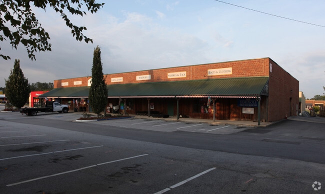
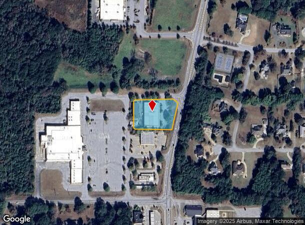
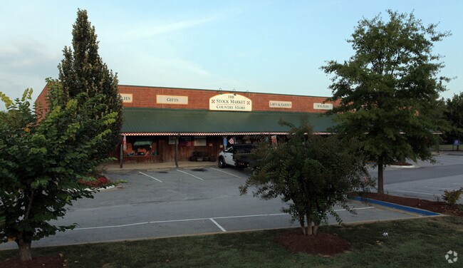
4479 Highway 20 Se, Conyers, GA 30013
NEARBY LISTINGS FOR SALE OR LEASE
-
-
View all Conyers listings for sale on LoopNet.com
Property Detail
4479 Highway 20 Se
Atlanta-Sandy Springs-Roswell, GA
Commercial
050-0-01-043E
HIGHWAY 20-TR2
Storebuilding
Rockdale
X
Georgia
13247C0159D
110
2024
1.33 AC
2025
Lithonia/Conyers
060406
Atlanta
12,600 SF
DEMOGRAPHICS near 4479 Highway 20 Se
1 Mile
3 Mile
5 Mile
2024 Total Population
3,859
30,475
82,165
2029 Population
4,001
32,184
87,654
Pop Growth 2024-2029
+ 3.68%
+ 5.61%
+ 6.68%
Average Age
41
40
39
2024 Total Households
1,372
10,563
28,497
HH Growth 2024-2029
+ 3.72%
+ 5.68%
+ 6.80%
Median Household Inc
$68,863
$79,464
$75,334
Avg Household Size
2.80
2.80
2.80
2024 Avg HH Vehicles
2.00
2.00
2.00
Median Home Value
$186,446
$220,387
$216,231
Median Year Built
1987
1990
1994
Nearby Places
Map Layers
Map Styles
 Street
 Aerial
- Restaurants
- Banks
- Shops
- Fitness
- Groceries
PUBLIC TRANSPORTATION
AIRPORT
Hartsfield - Jackson Atlanta International
DRIVE
WALK
Distance
Hartsfield - Jackson Atlanta International
50 min
34.9 mi
Nearby Properties
Address
Land Use
TOTAL SIZE
Lot Size
Zoning
Address
Land Use
TOTAL SIZE
Lot Size
Zoning
175,605 SF
39.99 AC
AR
Address
Land Use
TOTAL SIZE
Lot Size
Zoning
130,000 SF
33.48 AC
R1
Address
Land Use
TOTAL SIZE
Lot Size
Zoning
65,360 SF
75.51 AC
E6
Address
Land Use
TOTAL SIZE
Lot Size
Zoning
18,648 SF
2.48 AC
C1
Address
Land Use
TOTAL SIZE
Lot Size
Zoning
81,591 SF
12.80 AC
C2
Address
Land Use
TOTAL SIZE
Lot Size
Zoning
66,660 SF
12.80 AC
C1
Address
Land Use
TOTAL SIZE
Lot Size
Zoning
81,730 SF
17.98 AC
C1
Address
Land Use
TOTAL SIZE
Lot Size
Zoning
181,858 SF
6.92 AC
I1
Address
Land Use
TOTAL SIZE
Lot Size
Zoning
38,250 SF
26.56 AC
AR
Address
Land Use
TOTAL SIZE
Lot Size
Zoning
65,360 SF
30.63 AC
E6
Address
Land Use
TOTAL SIZE
Lot Size
Zoning
27.26 AC
R1
Address
Land Use
TOTAL SIZE
Lot Size
Zoning
50,096 SF
4.19 AC
C1
Address
Land Use
TOTAL SIZE
Lot Size
Zoning
9,779 SF
1.41 AC
C1
Address
Land Use
TOTAL SIZE
Lot Size
Zoning
17,700 SF
1.69 AC
C2
Address
Land Use
TOTAL SIZE
Lot Size
Zoning
63,328 SF
10.67 AC
C2
Address
Land Use
TOTAL SIZE
Lot Size
Zoning
64,800 SF
16.19 AC
AR
Address
Land Use
TOTAL SIZE
Lot Size
Zoning
18,751 SF
4.14 AC
C2/OI
Address
Land Use
TOTAL SIZE
Lot Size
Zoning
6,000 SF
2.61 AC
C1
Address
Land Use
TOTAL SIZE
Lot Size
Zoning
30,000 SF
11.06 AC
E2
Address
Land Use
TOTAL SIZE
Lot Size
Zoning
13,332 SF
1.17 AC
C1
Address
Land Use
TOTAL SIZE
Lot Size
Zoning
17,558 SF
5.08 AC
AR/C1
Address
Land Use
TOTAL SIZE
Lot Size
Zoning
15,953 SF
1.94 AC
C1
Address
Land Use
TOTAL SIZE
Lot Size
Zoning
24,750 SF
6 AC
R1
Address
Land Use
TOTAL SIZE
Lot Size
Zoning
3,500 SF
0.85 AC
C1
Address
Land Use
TOTAL SIZE
Lot Size
Zoning
13,182 SF
1.89 AC
CN
Address
Land Use
TOTAL SIZE
Lot Size
Zoning
5,880 SF
0.54 AC
C1
Address
Land Use
TOTAL SIZE
Lot Size
Zoning
8,964 SF
0.86 AC
C2
Address
Land Use
TOTAL SIZE
Lot Size
Zoning
12,546 SF
3.44 AC
OI/C
Address
Land Use
TOTAL SIZE
Lot Size
Zoning
11,876 SF
115.43 AC
R1
The World's #1 Commercial Real Estate Marketplace
Connect with us
© 2026 CoStar Group
The information above has been obtained from sources believed reliable. While we do not doubt its accuracy we have not verified it and make no guarantee, warranty or representation about it. It is your responsibility to independently confirm its accuracy and completeness. Any projections, opinions, assumptions, or estimates used are for example only and do not represent the current or future performance of the property. The value of this transaction to you depends on tax and other factors which should be evaluated by your tax, financial, and legal advisors. You and your advisors should conduct a careful, independent investigation of the property to determine to your satisfaction the suitability of the property for your needs.