No Photo
Property Record
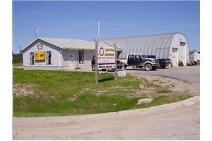
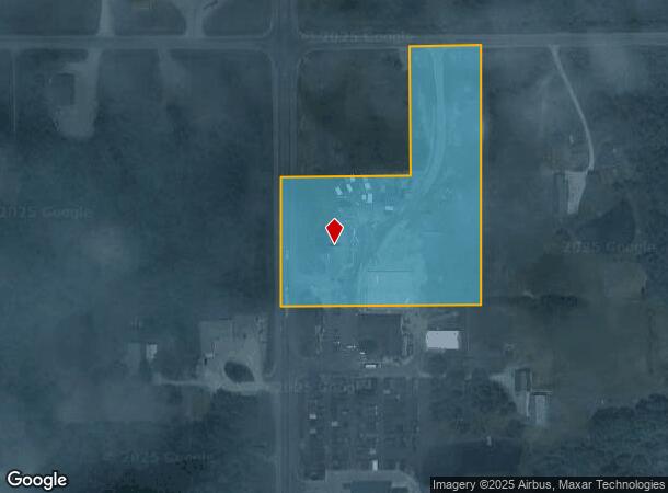
448 N Mount Tom Rd, Mio, MI 48647
NEARBY LISTINGS FOR SALE OR LEASE
-
-
View all Mio listings for sale on LoopNet.com
Property Detail
448 N Mount Tom Rd
Other Market Areas
T27N R3E SEC 31 - 5.23A M/L LD BEG 330' E OF NW COR OF SEC, TH E 180' TH S 660', W 510', N330', E 330,N 330', TO POB. 1996 SP
00303100370
Oscoda
Commercialnec
Michigan
2025
3.86 AC
2025
Michigan North Central Area
970300
DEMOGRAPHICS near 448 N Mount Tom Rd
1 mile
3 mile
5 mile
2024 Total Population
144
1,808
3,860
2029 Population
147
1,860
3,985
Pop Growth 2024-2029
+ 2.08%
+ 2.88%
+ 3.24%
Average Age
43
44
45
2024 Total Households
57
765
1,648
HH Growth 2024-2029
+ 1.75%
+ 2.35%
+ 2.73%
Median Household Inc
$58,333
$46,904
$49,567
Avg Household Size
2.50
2.30
2.30
2024 Avg HH Vehicles
2.00
2.00
2.00
Median Home Value
$140,000
$126,823
$133,333
Median Year Built
1976
1971
1973
Nearby Places
Map Layers
Map Styles
 Street
 Aerial
Transit
 Traffic
 Biking
Places
Listings with unknown addresses are not visible on the map
- Restaurants
- Banks
- Shops
- Fitness
- Groceries
Nearby Properties
Address
Land Use
TOTAL SIZE
Lot Size
Zoning
Address
Land Use
TOTAL SIZE
Lot Size
Zoning
1.70 AC
Address
Land Use
TOTAL SIZE
Lot Size
Zoning
1.60 AC
Address
Land Use
TOTAL SIZE
Lot Size
Zoning
25.67 AC
Address
Land Use
TOTAL SIZE
Lot Size
Zoning
Address
Land Use
TOTAL SIZE
Lot Size
Zoning
Address
Land Use
TOTAL SIZE
Lot Size
Zoning
132.53 AC
Address
Land Use
TOTAL SIZE
Lot Size
Zoning
2.02 AC
Address
Land Use
TOTAL SIZE
Lot Size
Zoning
88.67 AC
Address
Land Use
TOTAL SIZE
Lot Size
Zoning
76.30 AC
Address
Land Use
TOTAL SIZE
Lot Size
Zoning
1.61 AC
Address
Land Use
TOTAL SIZE
Lot Size
Zoning
240 AC
Address
Land Use
TOTAL SIZE
Lot Size
Zoning
54.70 AC
Address
Land Use
TOTAL SIZE
Lot Size
Zoning
1.74 AC
Address
Land Use
TOTAL SIZE
Lot Size
Zoning
141.94 AC
Address
Land Use
TOTAL SIZE
Lot Size
Zoning
38.55 AC
Address
Land Use
TOTAL SIZE
Lot Size
Zoning
155 AC
Address
Land Use
TOTAL SIZE
Lot Size
Zoning
1.38 AC
Address
Land Use
TOTAL SIZE
Lot Size
Zoning
1.49 AC
Address
Land Use
TOTAL SIZE
Lot Size
Zoning
200 AC
Address
Land Use
TOTAL SIZE
Lot Size
Zoning
1.50 AC
Address
Land Use
TOTAL SIZE
Lot Size
Zoning
153.95 AC
Address
Land Use
TOTAL SIZE
Lot Size
Zoning
76.23 AC
Address
Land Use
TOTAL SIZE
Lot Size
Zoning
143.71 AC
Address
Land Use
TOTAL SIZE
Lot Size
Zoning
71 AC
Address
Land Use
TOTAL SIZE
Lot Size
Zoning
Address
Land Use
TOTAL SIZE
Lot Size
Zoning
Address
Land Use
TOTAL SIZE
Lot Size
Zoning
Address
Land Use
TOTAL SIZE
Lot Size
Zoning
11.14 AC
Address
Land Use
TOTAL SIZE
Lot Size
Zoning
48.67 AC
Address
Land Use
TOTAL SIZE
Lot Size
Zoning
76.63 AC
The World's #1 Commercial Real Estate Marketplace
Connect with us
© 2026 CoStar Group
The information above has been obtained from sources believed reliable. While we do not doubt its accuracy we have not verified it and make no guarantee, warranty or representation about it. It is your responsibility to independently confirm its accuracy and completeness. Any projections, opinions, assumptions, or estimates used are for example only and do not represent the current or future performance of the property. The value of this transaction to you depends on tax and other factors which should be evaluated by your tax, financial, and legal advisors. You and your advisors should conduct a careful, independent investigation of the property to determine to your satisfaction the suitability of the property for your needs.