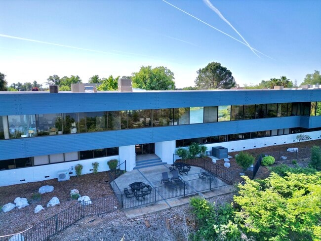
Property Record
448 Redcliff Dr, Redding, CA 96002

Save to a Folder
{{folder.Name}}
{{folder.ListingIds.length}} Properties
{{folder.ListingIds.length}} Property
Create a New Folder
Property Detail
448 Redcliff Dr
107-520-004-000
SOUTH40 FT FRONT & REAR MEAS LOT10 BLK2
Officebuilding
Shasta
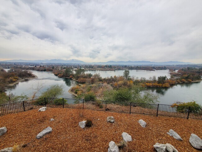
B and X Area of moderate flood hazard, usually the area between the limits of the 100-year and 500-year floods.
California
2025
1 AC
2026
Redding/Chico
010300
Other Market Areas
15,504 SF
Redding, CA
NEARBY LISTINGS FOR SALE OR LEASE
DEMOGRAPHICS near 448 Redcliff Dr
1 mile
3 mile
5 mile
2025 Total Population
5,578
69,383
102,995
2030 Population
5,594
69,637
103,500
Pop Growth 2025-2030
+ 0.29%
+ 0.37%
+ 0.49%
Average Age
41
40
41
2025 Total Households
2,451
28,267
41,258
HH Growth 2025-2030
+ 0.24%
+ 0.37%
+ 0.49%
Median Household Inc
$67,644
$70,574
$76,737
Avg Household Size
2.10
2.30
2.40
2025 Avg HH Vehicles
2.00
2.00
2.00
Median Home Value
$275,899
$360,946
$380,397
Median Year Built
1972
1980
1982
Nearby Places
Map Layers
Map Styles
 Street
 Aerial
Layers
 Traffic
 Biking
Places
Listings with unknown addresses are not visible on the map
- Restaurants
- Banks
- Shops
- Fitness
- Groceries
PUBLIC TRANSPORTATION
COMMUTER RAIL
Drive
Walk
Distance
7 min
3.8 mi
AIRPORT
Redding Regional
Drive
Walk
Distance
Redding Regional
13 min
7.7 mi
SALE & LEASE HISTORY
LISTING DATE
SALE/LEASE

Sep 25, 2016
For Lease
Jun 05, 2017
For Lease
Jul 26, 2017
For Lease
Aug 23, 2019
For Lease
Nearby Properties
Address
Land Use
TOTAL SIZE
Lot Size
Zoning
Address
Land Use
TOTAL SIZE
Lot Size
Zoning
15.20 AC
Address
Land Use
TOTAL SIZE
Lot Size
Zoning
2.60 AC
Address
Land Use
TOTAL SIZE
Lot Size
Zoning
208,310 SF
5.98 AC
Address
Land Use
TOTAL SIZE
Lot Size
Zoning
6.36 AC
Address
Land Use
TOTAL SIZE
Lot Size
Zoning
151,773 SF
17.64 AC
Address
Land Use
TOTAL SIZE
Lot Size
Zoning
1,016 SF
14.35 AC
Address
Land Use
TOTAL SIZE
Lot Size
Zoning
71,579 SF
4.37 AC
Address
Land Use
TOTAL SIZE
Lot Size
Zoning
Address
Land Use
TOTAL SIZE
Lot Size
Zoning
140.36 AC
Address
Land Use
TOTAL SIZE
Lot Size
Zoning
72,875 SF
3.93 AC
Address
Land Use
TOTAL SIZE
Lot Size
Zoning
31,365 SF
1.33 AC
Address
Land Use
TOTAL SIZE
Lot Size
Zoning
223,579 SF
19.65 AC
Address
Land Use
TOTAL SIZE
Lot Size
Zoning
4.10 AC
Address
Land Use
TOTAL SIZE
Lot Size
Zoning
89,098 SF
7.24 AC
Address
Land Use
TOTAL SIZE
Lot Size
Zoning
71,621 SF
8.22 AC
Address
Land Use
TOTAL SIZE
Lot Size
Zoning
21,089 SF
7 AC
Address
Land Use
TOTAL SIZE
Lot Size
Zoning
47,062 SF
4.80 AC
Address
Land Use
TOTAL SIZE
Lot Size
Zoning
73,000 SF
4.40 AC
Address
Land Use
TOTAL SIZE
Lot Size
Zoning
143,164 SF
13.90 AC
Address
Land Use
TOTAL SIZE
Lot Size
Zoning
54,720 SF
2.53 AC
Address
Land Use
TOTAL SIZE
Lot Size
Zoning
19,572 SF
5.94 AC
Address
Land Use
TOTAL SIZE
Lot Size
Zoning
5.44 AC
Address
Land Use
TOTAL SIZE
Lot Size
Zoning
81,800 SF
14.81 AC
Address
Land Use
TOTAL SIZE
Lot Size
Zoning
95,645 SF
9.55 AC
Address
Land Use
TOTAL SIZE
Lot Size
Zoning
61,754 SF
1.73 AC
Address
Land Use
TOTAL SIZE
Lot Size
Zoning
50,251 SF
4.06 AC
Address
Land Use
TOTAL SIZE
Lot Size
Zoning
92,699 SF
5.91 AC
Address
Land Use
TOTAL SIZE
Lot Size
Zoning
1,500 SF
69.70 AC
Address
Land Use
TOTAL SIZE
Lot Size
Zoning
10.27 AC
Address
Land Use
TOTAL SIZE
Lot Size
Zoning
104,740 SF
23.54 AC
The World's #1 Commercial Real Estate Marketplace
Connect with us
© 2026 CoStar Group
The information above has been obtained from sources believed reliable. While we do not doubt its accuracy we have not verified it and make no guarantee, warranty or representation about it. It is your responsibility to independently confirm its accuracy and completeness. Any projections, opinions, assumptions, or estimates used are for example only and do not represent the current or future performance of the property. The value of this transaction to you depends on tax and other factors which should be evaluated by your tax, financial, and legal advisors. You and your advisors should conduct a careful, independent investigation of the property to determine to your satisfaction the suitability of the property for your needs.