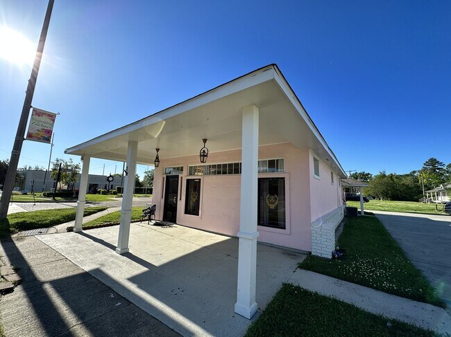
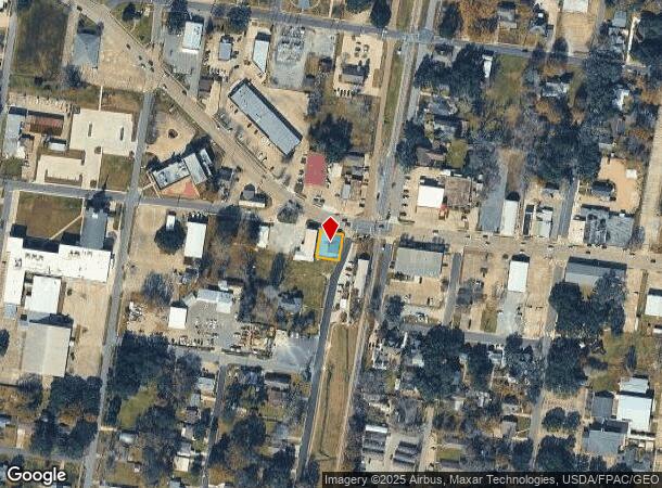
Property Record
4480 Main St, Zachary, LA 70791
NEARBY LISTINGS FOR SALE OR LEASE
-
-
View all Zachary listings for sale on LoopNet.com
Property Detail
4480 Main St
Baton Rouge, LA
Brown, George Tract
01523120
WARD: 2-3, SUBDIVISION: BROWN, GEORGE TRACT, LOT: 4, BLOCK: 83. A CERTAIN TRACT IN THE TOWN OF ZACHARY, BEGIN AT THE NW CORNER THENCE RUN E 72 FT S 8 0 FTW 72 FT N 80 FT BD N BY THE GREENWELL SPRINGS & PORT HUDSON RD E BY THE Y & M V RAILROAD S BY Y
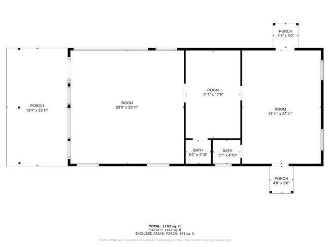
Storesoffices
E Baton Rouge
X
Louisiana
22033C0045F
4
2024
0.13 AC
2024
Zachary
004606
Baton Rouge
384 SF
DEMOGRAPHICS near 4480 Main St
1 Mile
3 Mile
5 Mile
2024 Total Population
4,568
18,792
35,947
2029 Population
4,467
18,403
35,255
Pop Growth 2024-2029
(2.21%)
(2.07%)
(1.93%)
Average Age
39
37
38
2024 Total Households
1,741
6,732
13,052
HH Growth 2024-2029
(2.18%)
(2.02%)
(1.95%)
Median Household Inc
$67,748
$75,089
$65,472
Avg Household Size
2.60
2.80
2.70
2024 Avg HH Vehicles
2.00
2.00
2.00
Median Home Value
$203,249
$248,297
$219,275
Median Year Built
1983
1994
1987
Nearby Places
Map Layers
Map Styles
 Street
 Aerial
- Restaurants
- Banks
- Shops
- Fitness
- Groceries
PUBLIC TRANSPORTATION
AIRPORT
Baton Rouge Metro Ryan Field
DRIVE
WALK
Distance
Baton Rouge Metro Ryan Field
17 min
11.0 mi
Freight Ports
Port of Greater Baton Rouge
DRIVE
WALK
Distance
Port of Greater Baton Rouge
31 min
19.8 mi
SALE & LEASE HISTORY
LISTING DATE
SALE/LEASE

Apr 10, 2024
For Sale
Nearby Properties
Address
Land Use
TOTAL SIZE
Lot Size
Zoning
Address
Land Use
TOTAL SIZE
Lot Size
Zoning
22.22 AC
Address
Land Use
TOTAL SIZE
Lot Size
Zoning
111,912 SF
28.33 AC
Address
Land Use
TOTAL SIZE
Lot Size
Zoning
15.41 AC
Address
Land Use
TOTAL SIZE
Lot Size
Zoning
Address
Land Use
TOTAL SIZE
Lot Size
Zoning
102,720 SF
10 AC
Address
Land Use
TOTAL SIZE
Lot Size
Zoning
82,615 SF
15.71 AC
Address
Land Use
TOTAL SIZE
Lot Size
Zoning
156,100 SF
16.32 AC
Address
Land Use
TOTAL SIZE
Lot Size
Zoning
9,994 SF
11.40 AC
Address
Land Use
TOTAL SIZE
Lot Size
Zoning
61,274 SF
2.91 AC
Address
Land Use
TOTAL SIZE
Lot Size
Zoning
102,513 SF
14.22 AC
Address
Land Use
TOTAL SIZE
Lot Size
Zoning
5.84 AC
Address
Land Use
TOTAL SIZE
Lot Size
Zoning
17,537 SF
20 AC
Address
Land Use
TOTAL SIZE
Lot Size
Zoning
47,750 SF
5.89 AC
Address
Land Use
TOTAL SIZE
Lot Size
Zoning
52,600 SF
11.31 AC
Address
Land Use
TOTAL SIZE
Lot Size
Zoning
2,668 SF
2.46 AC
Address
Land Use
TOTAL SIZE
Lot Size
Zoning
28,800 SF
3.26 AC
Address
Land Use
TOTAL SIZE
Lot Size
Zoning
Address
Land Use
TOTAL SIZE
Lot Size
Zoning
9,012 SF
2.72 AC
Address
Land Use
TOTAL SIZE
Lot Size
Zoning
Address
Land Use
TOTAL SIZE
Lot Size
Zoning
24,450 SF
2.26 AC
Address
Land Use
TOTAL SIZE
Lot Size
Zoning
35,982 SF
12.58 AC
Address
Land Use
TOTAL SIZE
Lot Size
Zoning
Address
Land Use
TOTAL SIZE
Lot Size
Zoning
99,786 SF
0.17 AC
Address
Land Use
TOTAL SIZE
Lot Size
Zoning
Address
Land Use
TOTAL SIZE
Lot Size
Zoning
40,188 SF
16.58 AC
Address
Land Use
TOTAL SIZE
Lot Size
Zoning
61,894 SF
1.50 AC
Address
Land Use
TOTAL SIZE
Lot Size
Zoning
Address
Land Use
TOTAL SIZE
Lot Size
Zoning
13,645 SF
3.38 AC
Address
Land Use
TOTAL SIZE
Lot Size
Zoning
1.24 AC
Address
Land Use
TOTAL SIZE
Lot Size
Zoning
35,751 SF
13.36 AC
The World's #1 Commercial Real Estate Marketplace
Connect with us
© 2025 CoStar Group
The information above has been obtained from sources believed reliable. While we do not doubt its accuracy we have not verified it and make no guarantee, warranty or representation about it. It is your responsibility to independently confirm its accuracy and completeness. Any projections, opinions, assumptions, or estimates used are for example only and do not represent the current or future performance of the property. The value of this transaction to you depends on tax and other factors which should be evaluated by your tax, financial, and legal advisors. You and your advisors should conduct a careful, independent investigation of the property to determine to your satisfaction the suitability of the property for your needs.