Property Record
4485 24Th Ave, Fort Gratiot, MI 48059


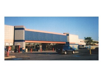
Property Detail
4485 24Th Ave
20-021-2016-010
BEG S 1D 10M 21S W 282.40', N 88D 59M 47S W 258' & N 1D 10M 21S E 61.17' FROM NE SEC COR, TH N 89D 12M 58S W 331.22', TH S 0D 36M 41S W 31.08', TH N 89D 12M 58S W 229.5', TH N 0D 36M 41S E 16.5', TH N 89D 12M 58S W 404.46', TH N 1D 10M 32S E 162.99'
Storebuilding
Saint Clair
C-2
Michigan
B and X Area of moderate flood hazard, usually the area between the limits of the 100-year and 500-year floods.
3.32 AC
2025
St Clair & Lapeer Counties
2025
Detroit
630100
Detroit-Warren-Dearborn, MI
17,813 SF
NEARBY LISTINGS FOR SALE OR LEASE
DEMOGRAPHICS near 4485 24Th Ave
1 mile
3 mile
5 mile
2025 Total Population
3,017
20,457
43,717
2030 Population
3,058
20,400
43,595
Pop Growth 2025-2030
+ 1.36%
(0.28%)
(0.28%)
Average Age
50
45
43
2025 Total Households
1,598
9,044
18,628
HH Growth 2025-2030
+ 1.25%
(0.32%)
(0.30%)
Median Household Inc
$62,812
$73,844
$64,060
Avg Household Size
1.90
2.20
2.30
2025 Avg HH Vehicles
1.00
2.00
2.00
Median Home Value
$217,067
$217,365
$193,936
Median Year Built
1984
1971
1968
Nearby Places
Map Layers
Map Styles
 Street
 Aerial
Layers
 Traffic
 Biking
Places
Listings with unknown addresses are not visible on the map
- Restaurants
- Banks
- Shops
- Fitness
- Groceries
PUBLIC TRANSPORTATION
COMMUTER RAIL
Drive
Walk
Distance
13 min
7.0 mi
Drive
Walk
Distance
19 min
8.5 mi
Nearby Properties
Address
Land Use
TOTAL SIZE
Lot Size
Zoning
Address
Land Use
TOTAL SIZE
Lot Size
Zoning
183,833 SF
14.34 AC
O-1
Address
Land Use
TOTAL SIZE
Lot Size
Zoning
220,212 SF
27.26 AC
C-2
Address
Land Use
TOTAL SIZE
Lot Size
Zoning
442,197 SF
43.84 AC
C-2
Address
Land Use
TOTAL SIZE
Lot Size
Zoning
27,675 SF
9.17 AC
C-2
Address
Land Use
TOTAL SIZE
Lot Size
Zoning
216,125 SF
27.95 AC
C-2
Address
Land Use
TOTAL SIZE
Lot Size
Zoning
72,725 SF
7.43 AC
RM
Address
Land Use
TOTAL SIZE
Lot Size
Zoning
5,106 SF
7.25 AC
R-1A*/SPCL
Address
Land Use
TOTAL SIZE
Lot Size
Zoning
137,905 SF
17.26 AC
C-2
Address
Land Use
TOTAL SIZE
Lot Size
Zoning
87,784 SF
10.45 AC
C-2
Address
Land Use
TOTAL SIZE
Lot Size
Zoning
45,723 SF
8.81 AC
C-2
Address
Land Use
TOTAL SIZE
Lot Size
Zoning
58,052 SF
16.94 AC
RM
Address
Land Use
TOTAL SIZE
Lot Size
Zoning
12.31 AC
C1
Address
Land Use
TOTAL SIZE
Lot Size
Zoning
6.92 AC
RM
Address
Land Use
TOTAL SIZE
Lot Size
Zoning
123,394 SF
3.10 AC
A1
Address
Land Use
TOTAL SIZE
Lot Size
Zoning
84,625 SF
7.24 AC
C-2
Address
Land Use
TOTAL SIZE
Lot Size
Zoning
101,737 SF
7.40 AC
C-2
Address
Land Use
TOTAL SIZE
Lot Size
Zoning
93,191 SF
6.20 AC
A1
Address
Land Use
TOTAL SIZE
Lot Size
Zoning
111,847 SF
13.79 AC
C-2
Address
Land Use
TOTAL SIZE
Lot Size
Zoning
2.66 AC
Address
Land Use
TOTAL SIZE
Lot Size
Zoning
97,236 SF
8.43 AC
RM
Address
Land Use
TOTAL SIZE
Lot Size
Zoning
28,225 SF
3.74 AC
C1
Address
Land Use
TOTAL SIZE
Lot Size
Zoning
50,851 SF
4.20 AC
C-2
Address
Land Use
TOTAL SIZE
Lot Size
Zoning
35,894 SF
4.12 AC
C-2
Address
Land Use
TOTAL SIZE
Lot Size
Zoning
46,424 SF
4.87 AC
C-2
Address
Land Use
TOTAL SIZE
Lot Size
Zoning
46,542 SF
4.97 AC
C-2
Address
Land Use
TOTAL SIZE
Lot Size
Zoning
87,624 SF
11.32 AC
RM
Address
Land Use
TOTAL SIZE
Lot Size
Zoning
100,144 SF
10 AC
A1
Address
Land Use
TOTAL SIZE
Lot Size
Zoning
108,976 SF
12.36 AC
A1
Address
Land Use
TOTAL SIZE
Lot Size
Zoning
93,542 SF
8.09 AC
C1
Address
Land Use
TOTAL SIZE
Lot Size
Zoning
90,243 SF
6.68 AC
C-2
The World's #1 Commercial Real Estate Marketplace
Connect with us
© 2026 CoStar Group
The information above has been obtained from sources believed reliable. While we do not doubt its accuracy we have not verified it and make no guarantee, warranty or representation about it. It is your responsibility to independently confirm its accuracy and completeness. Any projections, opinions, assumptions, or estimates used are for example only and do not represent the current or future performance of the property. The value of this transaction to you depends on tax and other factors which should be evaluated by your tax, financial, and legal advisors. You and your advisors should conduct a careful, independent investigation of the property to determine to your satisfaction the suitability of the property for your needs.