Property Record
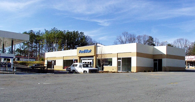
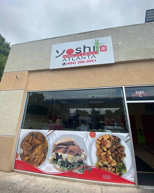
4485 Campbellton Rd Sw, Atlanta, GA 30331


NEARBY LISTINGS FOR SALE OR LEASE
Property Detail
4485 Campbellton Rd Sw
Atlanta-Sandy Springs-Roswell, GA
Not Shown
14F-0043-LL-062-5
KA CHEVRON WITH WINGZ, FOOD MART RAHIMS SEAFOOD, VERIFIED 7/19
Storebuilding
Fulton
X
Georgia
13121C0333F
43
2024
0.48 AC
2025
S Fulton/Union City
007809
Atlanta
6,203 SF
DEMOGRAPHICS near 4485 Campbellton Rd Sw
1 Mile
3 Mile
5 Mile
2024 Total Population
5,705
43,796
129,690
2029 Population
5,858
44,904
134,180
Pop Growth 2024-2029
+ 2.68%
+ 2.53%
+ 3.46%
Average Age
41
40
39
2024 Total Households
2,158
18,249
52,009
HH Growth 2024-2029
+ 2.73%
+ 2.55%
+ 3.50%
Median Household Inc
$63,177
$66,769
$60,543
Avg Household Size
2.50
2.40
2.40
2024 Avg HH Vehicles
2.00
2.00
2.00
Median Home Value
$202,559
$272,540
$267,660
Median Year Built
1980
1992
1983
Nearby Places
Map Layers
Map Styles
 Street
 Aerial
- Restaurants
- Banks
- Shops
- Fitness
- Groceries
PUBLIC TRANSPORTATION
AIRPORT
Hartsfield - Jackson Atlanta International
DRIVE
WALK
Distance
Hartsfield - Jackson Atlanta International
21 min
13.0 mi
SALE & LEASE HISTORY
LISTING DATE
SALE/LEASE

Nov 30, 2023
For Lease
Nearby Properties
Address
Land Use
TOTAL SIZE
Lot Size
Zoning
Address
Land Use
TOTAL SIZE
Lot Size
Zoning
312,984 SF
19.88 AC
Address
Land Use
TOTAL SIZE
Lot Size
Zoning
356,458 SF
18.72 AC
PDMU
Address
Land Use
TOTAL SIZE
Lot Size
Zoning
802,908 SF
18.26 AC
RG3
Address
Land Use
TOTAL SIZE
Lot Size
Zoning
830,966 SF
23 AC
MIXU
Address
Land Use
TOTAL SIZE
Lot Size
Zoning
5,459 SF
12.97 AC
C1
Address
Land Use
TOTAL SIZE
Lot Size
Zoning
282,610 SF
11.20 AC
C1
Address
Land Use
TOTAL SIZE
Lot Size
Zoning
364,391 SF
25.33 AC
R4
Address
Land Use
TOTAL SIZE
Lot Size
Zoning
814,536 SF
37 AC
R3
Address
Land Use
TOTAL SIZE
Lot Size
Zoning
274,442 SF
20.33 AC
RG2
Address
Land Use
TOTAL SIZE
Lot Size
Zoning
3,268,352 SF
23.31 AC
RG2
Address
Land Use
TOTAL SIZE
Lot Size
Zoning
135,211 SF
51.76 AC
OI
Address
Land Use
TOTAL SIZE
Lot Size
Zoning
274,956 SF
74.20 AC
AG1
Address
Land Use
TOTAL SIZE
Lot Size
Zoning
3,289,702 SF
16.23 AC
C1C
Address
Land Use
TOTAL SIZE
Lot Size
Zoning
42.90 AC
R4
Address
Land Use
TOTAL SIZE
Lot Size
Zoning
395,218 SF
21.61 AC
A1
Address
Land Use
TOTAL SIZE
Lot Size
Zoning
1,994,368 SF
17.10 AC
ACOND
Address
Land Use
TOTAL SIZE
Lot Size
Zoning
1,333,625 SF
15.28 AC
A1
Address
Land Use
TOTAL SIZE
Lot Size
Zoning
2,002,026 SF
17.51 AC
RLC
Address
Land Use
TOTAL SIZE
Lot Size
Zoning
9,590,784 SF
27.23 AC
RG3
Address
Land Use
TOTAL SIZE
Lot Size
Zoning
764,659 SF
51.57 AC
C1
Address
Land Use
TOTAL SIZE
Lot Size
Zoning
5,238,150 SF
24.10 AC
R3C
Address
Land Use
TOTAL SIZE
Lot Size
Zoning
1,715,322 SF
18.09 AC
A1
Address
Land Use
TOTAL SIZE
Lot Size
Zoning
725,612 SF
11.60 AC
A
Address
Land Use
TOTAL SIZE
Lot Size
Zoning
252,378 SF
19.20 AC
MIAC
Address
Land Use
TOTAL SIZE
Lot Size
Zoning
280,855 SF
17.13 AC
MIAC
Address
Land Use
TOTAL SIZE
Lot Size
Zoning
156,148 SF
27.07 AC
C1
Address
Land Use
TOTAL SIZE
Lot Size
Zoning
206,708 SF
5.75 AC
C1C
Address
Land Use
TOTAL SIZE
Lot Size
Zoning
49,173 SF
7.50 AC
C1C
Address
Land Use
TOTAL SIZE
Lot Size
Zoning
575,712 SF
3.29 AC
C1
Address
Land Use
TOTAL SIZE
Lot Size
Zoning
35,542 SF
405.72 AC
AC
The World's #1 Commercial Real Estate Marketplace
Connect with us
© 2025 CoStar Group
The information above has been obtained from sources believed reliable. While we do not doubt its accuracy we have not verified it and make no guarantee, warranty or representation about it. It is your responsibility to independently confirm its accuracy and completeness. Any projections, opinions, assumptions, or estimates used are for example only and do not represent the current or future performance of the property. The value of this transaction to you depends on tax and other factors which should be evaluated by your tax, financial, and legal advisors. You and your advisors should conduct a careful, independent investigation of the property to determine to your satisfaction the suitability of the property for your needs.