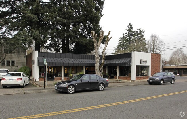
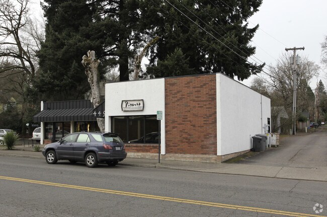
Property Record
449 B Ave, Lake Oswego, OR 97034

Property Detail
449 B Ave
00196754
29 1ST ADD TO OSWEGO LT 009 BLK 34
Commercialbuilding
Clackamas
EC
Oregon
B and X Area of moderate flood hazard, usually the area between the limits of the 100-year and 500-year floods.
009
2025
0.14 AC
2025
Lake Oswego/West Linn
020102
Portland
1 SF
Portland-Vancouver-Hillsboro, OR-WA
NEARBY LISTINGS FOR SALE OR LEASE
DEMOGRAPHICS near 449 B Ave
1 mile
3 mile
5 mile
2025 Total Population
9,155
85,859
274,877
2030 Population
9,231
86,070
274,560
Pop Growth 2025-2030
+ 0.83%
+ 0.25%
(0.12%)
Average Age
47
45
43
2025 Total Households
4,021
35,646
112,366
HH Growth 2025-2030
+ 0.80%
+ 0.20%
(0.20%)
Median Household Inc
$131,792
$113,812
$105,946
Avg Household Size
2.20
2.30
2.40
2025 Avg HH Vehicles
2.00
2.00
2.00
Median Home Value
$1,039,536
$754,341
$687,678
Median Year Built
1973
1976
1976
Nearby Places
Map Layers
Map Styles
 Street
 Aerial
Transit
 Traffic
 Biking
Places
Listings with unknown addresses are not visible on the map
- Restaurants
- Banks
- Shops
- Fitness
- Groceries
PUBLIC TRANSPORTATION
COMMUTER RAIL
Tigard Transit Center (Westside Express Service - Tri-County Metropolitan Transportation District of Oregon Rail (TriMet Rail))
Drive
Walk
Distance
Tigard Transit Center (Westside Express Service - Tri-County Metropolitan Transportation District of Oregon Rail (TriMet Rail))
15 min
6.4 mi
Drive
Walk
Distance
17 min
7.0 mi
AIRPORT
Portland International
Drive
Walk
Distance
Portland International
34 min
19.2 mi
Freight Ports
Port of Portland
Drive
Walk
Distance
Port of Portland
21 min
11.2 mi
Nearby Properties
Address
Land Use
TOTAL SIZE
Lot Size
Zoning
Address
Land Use
TOTAL SIZE
Lot Size
Zoning
931,749 SF
85.50 AC
CI1
Address
Land Use
TOTAL SIZE
Lot Size
Zoning
175,880 SF
36.43 AC
OS
Address
Land Use
TOTAL SIZE
Lot Size
Zoning
Address
Land Use
TOTAL SIZE
Lot Size
Zoning
138,295 SF
29.79 AC
CI1
Address
Land Use
TOTAL SIZE
Lot Size
Zoning
28.30 AC
EC/R-0
Address
Land Use
TOTAL SIZE
Lot Size
Zoning
20.82 AC
R-5
Address
Land Use
TOTAL SIZE
Lot Size
Zoning
6.48 AC
R-3
Address
Land Use
TOTAL SIZE
Lot Size
Zoning
Address
Land Use
TOTAL SIZE
Lot Size
Zoning
1 SF
1 AC
PF
Address
Land Use
TOTAL SIZE
Lot Size
Zoning
3,550 SF
3.99 AC
DMU
Address
Land Use
TOTAL SIZE
Lot Size
Zoning
5,724 SF
13.95 AC
NC/R-0
Address
Land Use
TOTAL SIZE
Lot Size
Zoning
1 SF
0.14 AC
EC
Address
Land Use
TOTAL SIZE
Lot Size
Zoning
10.35 AC
PF
Address
Land Use
TOTAL SIZE
Lot Size
Zoning
0.26 AC
C3
Address
Land Use
TOTAL SIZE
Lot Size
Zoning
21.39 AC
CI
Address
Land Use
TOTAL SIZE
Lot Size
Zoning
11.35 AC
C3
Address
Land Use
TOTAL SIZE
Lot Size
Zoning
5.12 AC
CR&D
Address
Land Use
TOTAL SIZE
Lot Size
Zoning
62,048 SF
8.58 AC
R20
Address
Land Use
TOTAL SIZE
Lot Size
Zoning
35.26 AC
PNA
Address
Land Use
TOTAL SIZE
Lot Size
Zoning
11.10 AC
HDR
Address
Land Use
TOTAL SIZE
Lot Size
Zoning
1.61 AC
DMU
Address
Land Use
TOTAL SIZE
Lot Size
Zoning
1 SF
4.73 AC
R-3
Address
Land Use
TOTAL SIZE
Lot Size
Zoning
7 AC
NME
Address
Land Use
TOTAL SIZE
Lot Size
Zoning
22.01 AC
BI
Address
Land Use
TOTAL SIZE
Lot Size
Zoning
6 AC
R-0
Address
Land Use
TOTAL SIZE
Lot Size
Zoning
122,430 SF
10.85 AC
NC
Address
Land Use
TOTAL SIZE
Lot Size
Zoning
3.45 AC
R-15
Address
Land Use
TOTAL SIZE
Lot Size
Zoning
1 SF
11.53 AC
OC/R-3
Address
Land Use
TOTAL SIZE
Lot Size
Zoning
8.37 AC
R-5
Address
Land Use
TOTAL SIZE
Lot Size
Zoning
The World's #1 Commercial Real Estate Marketplace
Connect with us
© 2026 CoStar Group
The information above has been obtained from sources believed reliable. While we do not doubt its accuracy we have not verified it and make no guarantee, warranty or representation about it. It is your responsibility to independently confirm its accuracy and completeness. Any projections, opinions, assumptions, or estimates used are for example only and do not represent the current or future performance of the property. The value of this transaction to you depends on tax and other factors which should be evaluated by your tax, financial, and legal advisors. You and your advisors should conduct a careful, independent investigation of the property to determine to your satisfaction the suitability of the property for your needs.