Property Record
449 E Wilbur Rd, Thousand Oaks, CA 91360

Property Detail
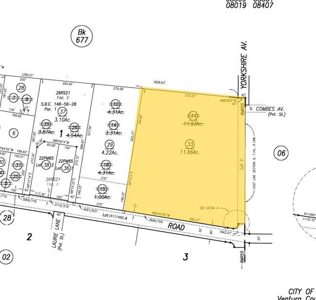
449 E Wilbur Rd
669-0-010-330
MAP G7 526
Daycare
Ventura
PL
California
C and X Area of minimal flood hazard, usually depicted on FIRMs as above the 500-year flood level.
11.66 AC
2024
Thousand Oaks/SE County
2025
Los Angeles
006800
Oxnard-Thousand Oaks-Ventura, CA
NEARBY LISTINGS FOR SALE OR LEASE
DEMOGRAPHICS near 449 E Wilbur Rd
1 mile
3 mile
5 mile
2025 Total Population
13,300
79,359
136,271
2030 Population
13,256
78,806
135,286
Pop Growth 2025-2030
(0.33%)
(0.70%)
(0.72%)
Average Age
42
43
44
2025 Total Households
5,074
28,972
50,218
HH Growth 2025-2030
(0.35%)
(0.78%)
(0.84%)
Median Household Inc
$89,634
$120,987
$140,094
Avg Household Size
2.50
2.60
2.60
2025 Avg HH Vehicles
2.00
2.00
2.00
Median Home Value
$826,757
$932,589
$1,018,502
Median Year Built
1971
1975
1977
Nearby Places
Map Layers
Map Styles
 Street
 Aerial
Transit
 Traffic
 Biking
Places
Listings with unknown addresses are not visible on the map
- Restaurants
- Banks
- Shops
- Fitness
- Groceries
PUBLIC TRANSPORTATION
COMMUTER RAIL
Moorpark (Ventura County Line - Southern California Regional Rail Authority (Metrolink))
Drive
Walk
Distance
Moorpark (Ventura County Line - Southern California Regional Rail Authority (Metrolink))
14 min
9.5 mi
AIRPORT
Bob Hope
Drive
Walk
Distance
Bob Hope
46 min
35.1 mi
Freight Ports
The Port of Hueneme
Drive
Walk
Distance
The Port of Hueneme
34 min
23.0 mi
Nearby Properties
Address
Land Use
TOTAL SIZE
Lot Size
Zoning
Address
Land Use
TOTAL SIZE
Lot Size
Zoning
2.08 AC
Address
Land Use
TOTAL SIZE
Lot Size
Zoning
13.12 AC
PL
Address
Land Use
TOTAL SIZE
Lot Size
Zoning
4,950 SF
50.22 AC
Address
Land Use
TOTAL SIZE
Lot Size
Zoning
Address
Land Use
TOTAL SIZE
Lot Size
Zoning
5.25 AC
Address
Land Use
TOTAL SIZE
Lot Size
Zoning
239,224 SF
11.65 AC
Address
Land Use
TOTAL SIZE
Lot Size
Zoning
253,686 SF
13.69 AC
RPD2
Address
Land Use
TOTAL SIZE
Lot Size
Zoning
233,391 SF
11.71 AC
RPD2
Address
Land Use
TOTAL SIZE
Lot Size
Zoning
Address
Land Use
TOTAL SIZE
Lot Size
Zoning
199,586 SF
8.95 AC
RPD25
Address
Land Use
TOTAL SIZE
Lot Size
Zoning
15,596 SF
3.17 AC
C2
Address
Land Use
TOTAL SIZE
Lot Size
Zoning
17,278 SF
15.46 AC
Address
Land Use
TOTAL SIZE
Lot Size
Zoning
182,756 SF
8.88 AC
RPD1
Address
Land Use
TOTAL SIZE
Lot Size
Zoning
162,078 SF
9.05 AC
R3
Address
Land Use
TOTAL SIZE
Lot Size
Zoning
10.32 AC
PL
Address
Land Use
TOTAL SIZE
Lot Size
Zoning
27.54 AC
PL
Address
Land Use
TOTAL SIZE
Lot Size
Zoning
135.43 AC
Address
Land Use
TOTAL SIZE
Lot Size
Zoning
1.94 AC
Address
Land Use
TOTAL SIZE
Lot Size
Zoning
6.93 AC
PL
Address
Land Use
TOTAL SIZE
Lot Size
Zoning
177,503 SF
5.36 AC
Address
Land Use
TOTAL SIZE
Lot Size
Zoning
26,654 SF
17.84 AC
C3
Address
Land Use
TOTAL SIZE
Lot Size
Zoning
2.07 AC
Address
Land Use
TOTAL SIZE
Lot Size
Zoning
127,196 SF
10.18 AC
MULT
Address
Land Use
TOTAL SIZE
Lot Size
Zoning
6,606 SF
5.42 AC
M1
Address
Land Use
TOTAL SIZE
Lot Size
Zoning
90,194 SF
4.12 AC
Address
Land Use
TOTAL SIZE
Lot Size
Zoning
73,421 SF
2.66 AC
C2
Address
Land Use
TOTAL SIZE
Lot Size
Zoning
74,757 SF
9.01 AC
Address
Land Use
TOTAL SIZE
Lot Size
Zoning
Address
Land Use
TOTAL SIZE
Lot Size
Zoning
68,015 SF
1.22 AC
Address
Land Use
TOTAL SIZE
Lot Size
Zoning
89,664 SF
5.03 AC
R-3
The World's #1 Commercial Real Estate Marketplace
Connect with us
© 2026 CoStar Group
The information above has been obtained from sources believed reliable. While we do not doubt its accuracy we have not verified it and make no guarantee, warranty or representation about it. It is your responsibility to independently confirm its accuracy and completeness. Any projections, opinions, assumptions, or estimates used are for example only and do not represent the current or future performance of the property. The value of this transaction to you depends on tax and other factors which should be evaluated by your tax, financial, and legal advisors. You and your advisors should conduct a careful, independent investigation of the property to determine to your satisfaction the suitability of the property for your needs.