Property Record
449 Knutson St, Mapleton, ND 58059


Save to a Folder
{{folder.Name}}
{{folder.ListingIds.length}} Properties
{{folder.ListingIds.length}} Property
Create a New Folder
Property Detail
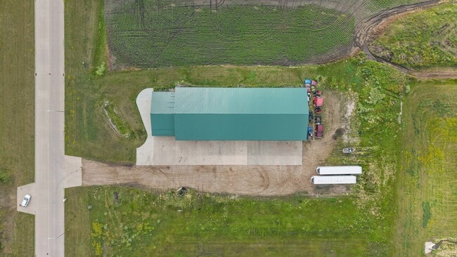
449 Knutson St
Fargo, ND-MN
LOT: 3 BLOCK: 2 ADDITION: MAPLETON I-94 DEVELOPMENT PARK 1ST ADDITION ADDITIONAL: MAPLETON I-94 DEVELOPMENT PARK 1ST ADDN LT
18-0520-00040-000
CASS
Commercialnec
North Dakota
B and X Area of moderate flood hazard, usually the area between the limits of the 100-year and 500-year floods.
3
2025
1.57 AC
2025
Fargo
040800
Other Market Areas
11,100 SF
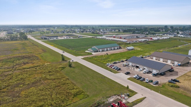
NEARBY LISTINGS FOR SALE OR LEASE
DEMOGRAPHICS near 449 Knutson St
1 mile
3 mile
5 mile
2025 Total Population
1,598
1,693
1,979
2030 Population
1,732
1,834
2,142
Pop Growth 2025-2030
+ 8.39%
+ 8.33%
+ 8.24%
Average Age
36
36
36
2025 Total Households
555
589
693
HH Growth 2025-2030
+ 8.83%
+ 8.66%
+ 8.51%
Median Household Inc
$121,840
$121,262
$120,243
Avg Household Size
2.90
2.90
2.90
2025 Avg HH Vehicles
2.00
2.00
2.00
Median Home Value
$350,000
$350,595
$346,500
Median Year Built
1992
1991
1991
Nearby Places
Map Layers
Map Styles
 Street
 Aerial
Layers
 Traffic
 Biking
Places
Listings with unknown addresses are not visible on the map
- Restaurants
- Banks
- Shops
- Fitness
- Groceries
PUBLIC TRANSPORTATION
AIRPORT
Hector International
Drive
Walk
Distance
Hector International
27 min
16.5 mi
Freight Ports
Port Milwaukee
Drive
Walk
Distance
Port Milwaukee
642 min
584.6 mi
SALE & LEASE HISTORY
LISTING DATE
SALE/LEASE

Jul 29, 2025
For Sale
Nearby Properties
Address
Land Use
TOTAL SIZE
Lot Size
Zoning
Address
Land Use
TOTAL SIZE
Lot Size
Zoning
106,400 SF
20 AC
Address
Land Use
TOTAL SIZE
Lot Size
Zoning
164,569 SF
2.47 AC
Address
Land Use
TOTAL SIZE
Lot Size
Zoning
50,962 SF
9.99 AC
Address
Land Use
TOTAL SIZE
Lot Size
Zoning
1,624 SF
Address
Land Use
TOTAL SIZE
Lot Size
Zoning
42,252 SF
9.53 AC
Address
Land Use
TOTAL SIZE
Lot Size
Zoning
21,410 SF
2.08 AC
Address
Land Use
TOTAL SIZE
Lot Size
Zoning
60,000 SF
6.50 AC
Address
Land Use
TOTAL SIZE
Lot Size
Zoning
48,762 SF
11.88 AC
Address
Land Use
TOTAL SIZE
Lot Size
Zoning
17,700 SF
10 AC
Address
Land Use
TOTAL SIZE
Lot Size
Zoning
23,344 SF
1.85 AC
Address
Land Use
TOTAL SIZE
Lot Size
Zoning
Address
Land Use
TOTAL SIZE
Lot Size
Zoning
Address
Land Use
TOTAL SIZE
Lot Size
Zoning
17,568 SF
2.83 AC
Address
Land Use
TOTAL SIZE
Lot Size
Zoning
12,600 SF
4.07 AC
Address
Land Use
TOTAL SIZE
Lot Size
Zoning
8,640 SF
1.74 AC
Address
Land Use
TOTAL SIZE
Lot Size
Zoning
2,240 SF
2.80 AC
Address
Land Use
TOTAL SIZE
Lot Size
Zoning
10,756 SF
Address
Land Use
TOTAL SIZE
Lot Size
Zoning
7,680 SF
2.06 AC
Address
Land Use
TOTAL SIZE
Lot Size
Zoning
Address
Land Use
TOTAL SIZE
Lot Size
Zoning
9,666 SF
0.64 AC
Address
Land Use
TOTAL SIZE
Lot Size
Zoning
12,000 SF
2.25 AC
Address
Land Use
TOTAL SIZE
Lot Size
Zoning
Address
Land Use
TOTAL SIZE
Lot Size
Zoning
10,080 SF
2 AC
Address
Land Use
TOTAL SIZE
Lot Size
Zoning
3,017 SF
8.75 AC
Address
Land Use
TOTAL SIZE
Lot Size
Zoning
3,488 SF
7.29 AC
Address
Land Use
TOTAL SIZE
Lot Size
Zoning
0.31 AC
Address
Land Use
TOTAL SIZE
Lot Size
Zoning
5,040 SF
100.27 AC
Address
Land Use
TOTAL SIZE
Lot Size
Zoning
7,680 SF
Address
Land Use
TOTAL SIZE
Lot Size
Zoning
5,832 SF
3.10 AC
The World's #1 Commercial Real Estate Marketplace
Connect with us
© 2026 CoStar Group
The information above has been obtained from sources believed reliable. While we do not doubt its accuracy we have not verified it and make no guarantee, warranty or representation about it. It is your responsibility to independently confirm its accuracy and completeness. Any projections, opinions, assumptions, or estimates used are for example only and do not represent the current or future performance of the property. The value of this transaction to you depends on tax and other factors which should be evaluated by your tax, financial, and legal advisors. You and your advisors should conduct a careful, independent investigation of the property to determine to your satisfaction the suitability of the property for your needs.