Property Record
449 Mclaws Cir, Williamsburg, VA 23185

NEARBY LISTINGS FOR SALE OR LEASE
Property Detail
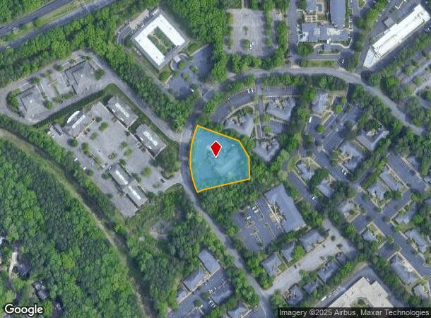
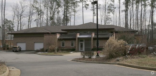
449 Mclaws Cir
50-2 01-0-0086
Busch Corporate Center
Commercialnec
P-58B A PORTION OF PARCEL C BUSCH CORP CENTER
X
James City
51095C0206D
Virginia
2025
1.24 AC
2025
Williamsburg/J City Cnty
080103
Hampton Roads
10,844 SF
Virginia Beach-Norfolk-Newport News, VA-NC
DEMOGRAPHICS near 449 Mclaws Cir
1 Mile
3 Mile
5 Mile
2024 Total Population
5,926
24,303
49,305
2029 Population
6,482
26,362
53,690
Pop Growth 2024-2029
+ 9.38%
+ 8.47%
+ 8.89%
Average Age
40
42
41
2024 Total Households
2,200
9,452
18,508
HH Growth 2024-2029
+ 10.09%
+ 9.35%
+ 9.84%
Median Household Inc
$88,427
$90,543
$83,210
Avg Household Size
2.40
2.40
2.30
2024 Avg HH Vehicles
2.00
2.00
2.00
Median Home Value
$370,443
$375,970
$359,461
Median Year Built
1986
1987
1988
Nearby Places
Map Layers
Map Styles
 Street
 Aerial
- Restaurants
- Banks
- Shops
- Fitness
- Groceries
PUBLIC TRANSPORTATION
AIRPORT
Newport News/Williamsburg International
DRIVE
WALK
Distance
Newport News/Williamsburg International
25 min
14.3 mi
Nearby Properties
Address
Land Use
TOTAL SIZE
Lot Size
Zoning
Address
Land Use
TOTAL SIZE
Lot Size
Zoning
691,260 SF
383.07 AC
M1 LIMITED
Address
Land Use
TOTAL SIZE
Lot Size
Zoning
1,938,121 SF
81.88 AC
M2 GENERAL
Address
Land Use
TOTAL SIZE
Lot Size
Zoning
3,696 SF
222 AC
ECONOMIC O
Address
Land Use
TOTAL SIZE
Lot Size
Zoning
87,083 SF
55.74 AC
WM (WILLIA
Address
Land Use
TOTAL SIZE
Lot Size
Zoning
88,000 SF
11.48 AC
MS (MUSEUM
Address
Land Use
TOTAL SIZE
Lot Size
Zoning
301,801 SF
13.49 AC
PLANNED DE
Address
Land Use
TOTAL SIZE
Lot Size
Zoning
10,144 SF
87.57 AC
R5 MULTIFA
Address
Land Use
TOTAL SIZE
Lot Size
Zoning
109,842 SF
17.34 AC
ED-C (ECON
Address
Land Use
TOTAL SIZE
Lot Size
Zoning
164,647 SF
34.11 AC
MS (MUSEUM
Address
Land Use
TOTAL SIZE
Lot Size
Zoning
14,448 SF
6.94 AC
WM (WILLIA
Address
Land Use
TOTAL SIZE
Lot Size
Zoning
58,107 SF
14.62 AC
ED-C (ECON
Address
Land Use
TOTAL SIZE
Lot Size
Zoning
36,545 SF
11.48 AC
MS (MUSEUM
Address
Land Use
TOTAL SIZE
Lot Size
Zoning
4,815 SF
37.84 AC
PL PUBLIC
Address
Land Use
TOTAL SIZE
Lot Size
Zoning
96,955 SF
4.12 AC
ED-C (ECON
Address
Land Use
TOTAL SIZE
Lot Size
Zoning
149,179 SF
3 AC
ED-C (ECON
Address
Land Use
TOTAL SIZE
Lot Size
Zoning
53,014 SF
34.74 AC
MS (MUSEUM
Address
Land Use
TOTAL SIZE
Lot Size
Zoning
12,444 SF
26.96 AC
RM-2 (MULT
Address
Land Use
TOTAL SIZE
Lot Size
Zoning
66,897 SF
4.73 AC
ED-C (ECON
Address
Land Use
TOTAL SIZE
Lot Size
Zoning
150,978 SF
6.25 AC
PLANNED DE
Address
Land Use
TOTAL SIZE
Lot Size
Zoning
6,688 SF
5.37 AC
CW (COLONI
Address
Land Use
TOTAL SIZE
Lot Size
Zoning
227,115 SF
7.54 AC
PLANNED DE
Address
Land Use
TOTAL SIZE
Lot Size
Zoning
52,523 SF
14.88 AC
ED-C (ECON
Address
Land Use
TOTAL SIZE
Lot Size
Zoning
42,796 SF
7.14 AC
LB-1 (LIMI
Address
Land Use
TOTAL SIZE
Lot Size
Zoning
44,000 SF
2.35 AC
MS (MUSEUM
Address
Land Use
TOTAL SIZE
Lot Size
Zoning
8,886 SF
2.05 AC
B-2 (CORRI
Address
Land Use
TOTAL SIZE
Lot Size
Zoning
11,400 SF
13 AC
RM-2 (MULT
Address
Land Use
TOTAL SIZE
Lot Size
Zoning
60,000 SF
3.97 AC
RS-2 (SING
Address
Land Use
TOTAL SIZE
Lot Size
Zoning
2,488 SF
2.98 AC
WM (WILLIA
The World's #1 Commercial Real Estate Marketplace
Connect with us
© 2025 CoStar Group
The information above has been obtained from sources believed reliable. While we do not doubt its accuracy we have not verified it and make no guarantee, warranty or representation about it. It is your responsibility to independently confirm its accuracy and completeness. Any projections, opinions, assumptions, or estimates used are for example only and do not represent the current or future performance of the property. The value of this transaction to you depends on tax and other factors which should be evaluated by your tax, financial, and legal advisors. You and your advisors should conduct a careful, independent investigation of the property to determine to your satisfaction the suitability of the property for your needs.