Property Record
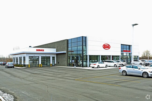
44900 N Gratiot Ave, Clinton Township, MI 48036


NEARBY LISTINGS FOR SALE OR LEASE
Property Detail
44900 N Gratiot Ave
Detroit-Warren-Dearborn, MI
North Gratiot Heights Sub
16-11-01-202-026
NORTH GRATIOT HEIGHTS SUB L 21 P 3 ALL LOTS 1, 2, 7 THRU 11; PART OF LOTS 3, 4, 5, 6; ALSO, T2N, R13E, SEC 1; TOGETHER DESC
Vehiclerentalsvehiclesales
Macomb
X
Michigan
26099C0263G
1-7
2025
5.58 AC
2025
Macomb East
240000
Detroit
22,950 SF
DEMOGRAPHICS near 44900 N Gratiot Ave
1 Mile
3 Mile
5 Mile
2024 Total Population
4,902
60,505
176,561
2029 Population
4,944
60,215
175,324
Pop Growth 2024-2029
+ 0.86%
(0.48%)
(0.70%)
Average Age
40
40
41
2024 Total Households
1,894
24,526
72,283
HH Growth 2024-2029
+ 0.95%
(0.47%)
(0.65%)
Median Household Inc
$77,361
$69,895
$76,388
Avg Household Size
2.50
2.40
2.40
2024 Avg HH Vehicles
2.00
2.00
2.00
Median Home Value
$218,963
$243,836
$251,249
Median Year Built
1992
1991
1989
Nearby Places
Map Layers
Map Styles
 Street
 Aerial
- Restaurants
- Banks
- Shops
- Fitness
- Groceries
PUBLIC TRANSPORTATION
AIRPORT
Windsor International
DRIVE
WALK
Distance
Windsor International
59 min
37.2 mi
Freight Ports
Port of Toledo
DRIVE
WALK
Distance
Port of Toledo
108 min
87.6 mi
Nearby Properties
Address
Land Use
TOTAL SIZE
Lot Size
Zoning
Address
Land Use
TOTAL SIZE
Lot Size
Zoning
122.50 AC
RML
Address
Land Use
TOTAL SIZE
Lot Size
Zoning
20,891 SF
289.61 AC
R3
Address
Land Use
TOTAL SIZE
Lot Size
Zoning
404,160 SF
22.52 AC
I-1
Address
Land Use
TOTAL SIZE
Lot Size
Zoning
44.65 AC
RML
Address
Land Use
TOTAL SIZE
Lot Size
Zoning
20.27 AC
RML
Address
Land Use
TOTAL SIZE
Lot Size
Zoning
25.14 AC
RML
Address
Land Use
TOTAL SIZE
Lot Size
Zoning
252,226 SF
52.79 AC
Address
Land Use
TOTAL SIZE
Lot Size
Zoning
26.92 AC
RML
Address
Land Use
TOTAL SIZE
Lot Size
Zoning
670,448 SF
37.23 AC
L-2
Address
Land Use
TOTAL SIZE
Lot Size
Zoning
196,459 SF
19.18 AC
I-1
Address
Land Use
TOTAL SIZE
Lot Size
Zoning
229,878 SF
19.93 AC
C4 MULT
Address
Land Use
TOTAL SIZE
Lot Size
Zoning
42,385 SF
25.55 AC
B-2
Address
Land Use
TOTAL SIZE
Lot Size
Zoning
72,572 SF
10 AC
B-3
Address
Land Use
TOTAL SIZE
Lot Size
Zoning
134,327 SF
10.02 AC
I-1
Address
Land Use
TOTAL SIZE
Lot Size
Zoning
600 SF
18.79 AC
R2L
Address
Land Use
TOTAL SIZE
Lot Size
Zoning
87.32 AC
MH
Address
Land Use
TOTAL SIZE
Lot Size
Zoning
115,349 SF
14.39 AC
C3
Address
Land Use
TOTAL SIZE
Lot Size
Zoning
45,864 SF
4.60 AC
C2
Address
Land Use
TOTAL SIZE
Lot Size
Zoning
120,360 SF
10.70 AC
GC
Address
Land Use
TOTAL SIZE
Lot Size
Zoning
149,652 SF
8.04 AC
SP-1
Address
Land Use
TOTAL SIZE
Lot Size
Zoning
99,717 SF
2.14 AC
I-1
Address
Land Use
TOTAL SIZE
Lot Size
Zoning
322,418 SF
8.08 AC
MU
Address
Land Use
TOTAL SIZE
Lot Size
Zoning
252,226 SF
49.16 AC
Address
Land Use
TOTAL SIZE
Lot Size
Zoning
136,474 SF
12.62 AC
I-1
Address
Land Use
TOTAL SIZE
Lot Size
Zoning
98,014 SF
8.69 AC
I-1
Address
Land Use
TOTAL SIZE
Lot Size
Zoning
123,184 SF
10.02 AC
I-1
Address
Land Use
TOTAL SIZE
Lot Size
Zoning
218,662 SF
16.61 AC
M2 GEN
Address
Land Use
TOTAL SIZE
Lot Size
Zoning
138,834 SF
16.46 AC
I-1
Address
Land Use
TOTAL SIZE
Lot Size
Zoning
84,112 SF
8.01 AC
I-1
Address
Land Use
TOTAL SIZE
Lot Size
Zoning
56,709 SF
10.84 AC
I-1
The World's #1 Commercial Real Estate Marketplace
Connect with us
© 2026 CoStar Group
The information above has been obtained from sources believed reliable. While we do not doubt its accuracy we have not verified it and make no guarantee, warranty or representation about it. It is your responsibility to independently confirm its accuracy and completeness. Any projections, opinions, assumptions, or estimates used are for example only and do not represent the current or future performance of the property. The value of this transaction to you depends on tax and other factors which should be evaluated by your tax, financial, and legal advisors. You and your advisors should conduct a careful, independent investigation of the property to determine to your satisfaction the suitability of the property for your needs.