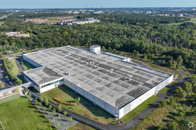
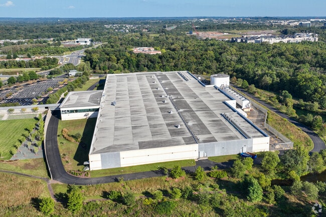
Property Record
44901 Russell Branch Pky, Ashburn, VA 20147
NEARBY LISTINGS FOR SALE OR LEASE
Property Detail
44901 Russell Branch Pky
040-46-4286
Dulles Overlook
Notresolvable
DULLES OVERLOOK PARCEL B2 201904150018155/6P HWY TAKE, 201802050006453ESMT 201512170082956/7P BLA, 200903020011478P, 200708170061038
AE
Loudoun
51107C0265E
Virginia
2025
41.28 AC
2025
Rt 28/Dulles North
611015
Washington, DC
481,791 SF
Washington-Arlington-Alexandria, DC-VA-MD-WV
DEMOGRAPHICS near 44901 Russell Branch Pky
1 Mile
3 Mile
5 Mile
2024 Total Population
9,288
71,505
194,549
2029 Population
10,419
77,300
209,523
Pop Growth 2024-2029
+ 12.18%
+ 8.10%
+ 7.70%
Average Age
40
41
39
2024 Total Households
3,882
27,608
67,104
HH Growth 2024-2029
+ 12.24%
+ 8.43%
+ 8.00%
Median Household Inc
$127,877
$129,398
$142,617
Avg Household Size
2.30
2.60
2.80
2024 Avg HH Vehicles
2.00
2.00
2.00
Median Home Value
$667,256
$646,609
$639,409
Median Year Built
2010
1999
1997
Nearby Places
Map Layers
Map Styles
 Street
 Aerial
- Restaurants
- Banks
- Shops
- Fitness
- Groceries
PUBLIC TRANSPORTATION
AIRPORT
Washington Dulles International
DRIVE
WALK
Distance
Washington Dulles International
20 min
9.4 mi
Ronald Reagan Washington Ntl
DRIVE
WALK
Distance
Ronald Reagan Washington Ntl
50 min
31.7 mi
Freight Ports
Port of Baltimore
DRIVE
WALK
Distance
Port of Baltimore
90 min
63.6 mi
Nearby Properties
Address
Land Use
TOTAL SIZE
Lot Size
Zoning
Address
Land Use
TOTAL SIZE
Lot Size
Zoning
518,449 SF
32.11 AC
IP
Address
Land Use
TOTAL SIZE
Lot Size
Zoning
521,784 SF
PDOP
Address
Land Use
TOTAL SIZE
Lot Size
Zoning
462,210 SF
PDOP
Address
Land Use
TOTAL SIZE
Lot Size
Zoning
650,346 SF
PDMUB
Address
Land Use
TOTAL SIZE
Lot Size
Zoning
1,434,706 SF
30.91 AC
PDRDP
Address
Land Use
TOTAL SIZE
Lot Size
Zoning
789,350 SF
31.73 AC
PDOP
Address
Land Use
TOTAL SIZE
Lot Size
Zoning
446,512 SF
25.41 AC
IP
Address
Land Use
TOTAL SIZE
Lot Size
Zoning
368,624 SF
8.85 AC
PDOP
Address
Land Use
TOTAL SIZE
Lot Size
Zoning
672,272 SF
44.53 AC
PDIP
Address
Land Use
TOTAL SIZE
Lot Size
Zoning
679,455 SF
31.97 AC
PDIP
Address
Land Use
TOTAL SIZE
Lot Size
Zoning
2,735,138 SF
123.03 AC
PDAAAR
Address
Land Use
TOTAL SIZE
Lot Size
Zoning
288,403 SF
16.56 AC
PDOP
Address
Land Use
TOTAL SIZE
Lot Size
Zoning
286,865 SF
18.56 AC
IP
Address
Land Use
TOTAL SIZE
Lot Size
Zoning
493,504 SF
15.73 AC
PDOP
Address
Land Use
TOTAL SIZE
Lot Size
Zoning
684,976 SF
85.31 AC
PDOP
Address
Land Use
TOTAL SIZE
Lot Size
Zoning
286,800 SF
10.97 AC
IP
Address
Land Use
TOTAL SIZE
Lot Size
Zoning
455,793 SF
22.60 AC
IP
Address
Land Use
TOTAL SIZE
Lot Size
Zoning
362,108 SF
18.82 AC
PDOP
Address
Land Use
TOTAL SIZE
Lot Size
Zoning
400,232 SF
21.38 AC
IP
Address
Land Use
TOTAL SIZE
Lot Size
Zoning
154,125 SF
9.68 AC
PDIP
Address
Land Use
TOTAL SIZE
Lot Size
Zoning
169,092 SF
PDMUB
Address
Land Use
TOTAL SIZE
Lot Size
Zoning
109,320 SF
7.20 AC
PDIP
Address
Land Use
TOTAL SIZE
Lot Size
Zoning
1,070,060 SF
197.44 AC
PDRDP
Address
Land Use
TOTAL SIZE
Lot Size
Zoning
685,682 SF
53.96 AC
PDIP
Address
Land Use
TOTAL SIZE
Lot Size
Zoning
123,200 SF
4.74 AC
PDIP
Address
Land Use
TOTAL SIZE
Lot Size
Zoning
405,058 SF
19.88 AC
IP
Address
Land Use
TOTAL SIZE
Lot Size
Zoning
585,593 SF
15.38 AC
PDOP
Address
Land Use
TOTAL SIZE
Lot Size
Zoning
414,268 SF
43.68 AC
R16
Address
Land Use
TOTAL SIZE
Lot Size
Zoning
259,194 SF
10.18 AC
PDIP
The World's #1 Commercial Real Estate Marketplace
Connect with us
© 2026 CoStar Group
The information above has been obtained from sources believed reliable. While we do not doubt its accuracy we have not verified it and make no guarantee, warranty or representation about it. It is your responsibility to independently confirm its accuracy and completeness. Any projections, opinions, assumptions, or estimates used are for example only and do not represent the current or future performance of the property. The value of this transaction to you depends on tax and other factors which should be evaluated by your tax, financial, and legal advisors. You and your advisors should conduct a careful, independent investigation of the property to determine to your satisfaction the suitability of the property for your needs.