Property Record
4491 E 22Nd St, Fremont, NE 68025
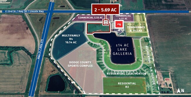
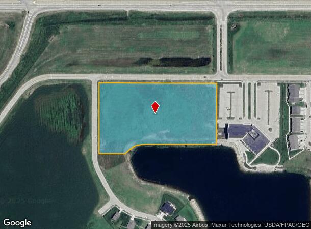
This Property Is For Sale
NEARBY LISTINGS FOR SALE OR LEASE
Property Detail
4491 E 22Nd St
Fremont, NE
Gallery 23 East Add Replat 1
270140431
GALLERY 23 EAST ADD REPLAT 1 LOT 1 BLK 1 5.69A 17 17 9; MAP NUMBER: 2389-17-2-00000-000-0001
Commercialacreage
Dodge
X
Nebraska
31177C0250D
1
2024
5.69 AC
2024
Nebraska Area
964200
Other Market Areas
DEMOGRAPHICS near 4491 E 22Nd St
1 Mile
3 Mile
5 Mile
2024 Total Population
587
17,707
30,873
2029 Population
639
17,686
30,818
Pop Growth 2024-2029
+ 8.86%
(0.12%)
(0.18%)
Average Age
42
41
40
2024 Total Households
228
7,057
12,273
HH Growth 2024-2029
+ 8.33%
+ 0.04%
(0.15%)
Median Household Inc
$70,344
$66,200
$61,961
Avg Household Size
2.50
2.40
2.40
2024 Avg HH Vehicles
2.00
2.00
2.00
Median Home Value
$151,369
$172,518
$173,557
Median Year Built
1993
1967
1968
Nearby Places
Map Layers
Map Styles
 Street
 Aerial
- Restaurants
- Banks
- Shops
- Fitness
- Groceries
Nearby Properties
Address
Land Use
TOTAL SIZE
Lot Size
Zoning
Address
Land Use
TOTAL SIZE
Lot Size
Zoning
28,281 SF
14.60 AC
COMMERCIAL
Address
Land Use
TOTAL SIZE
Lot Size
Zoning
162,301 SF
18.06 AC
COMMERCIAL
Address
Land Use
TOTAL SIZE
Lot Size
Zoning
200,088 SF
23.04 AC
COMMERCIAL
Address
Land Use
TOTAL SIZE
Lot Size
Zoning
52,993 SF
4 AC
COMMERCIAL
Address
Land Use
TOTAL SIZE
Lot Size
Zoning
4,120 SF
9.44 AC
MULTI-FAMI
Address
Land Use
TOTAL SIZE
Lot Size
Zoning
67,947 SF
10.67 AC
INDUSTRIAL
Address
Land Use
TOTAL SIZE
Lot Size
Zoning
33,392 SF
5.57 AC
SINGLE-FAM
Address
Land Use
TOTAL SIZE
Lot Size
Zoning
59,307 SF
1.99 AC
COMMERCIAL
Address
Land Use
TOTAL SIZE
Lot Size
Zoning
20,314 SF
44.71 AC
INDUSTRIAL
Address
Land Use
TOTAL SIZE
Lot Size
Zoning
65,589 SF
5.76 AC
COMMERCIAL
Address
Land Use
TOTAL SIZE
Lot Size
Zoning
53,688 SF
2.27 AC
MULTI-FAMI
Address
Land Use
TOTAL SIZE
Lot Size
Zoning
45,228 SF
2.01 AC
COMMERCIAL
Address
Land Use
TOTAL SIZE
Lot Size
Zoning
65,171 SF
16.10 AC
INDUSTRIAL
Address
Land Use
TOTAL SIZE
Lot Size
Zoning
43,560 SF
1.75 AC
COMMERCIAL
Address
Land Use
TOTAL SIZE
Lot Size
Zoning
59,225 SF
5.41 AC
COMMERCIAL
Address
Land Use
TOTAL SIZE
Lot Size
Zoning
9,870 SF
5.13 AC
COMMERCIAL
Address
Land Use
TOTAL SIZE
Lot Size
Zoning
16,360 SF
1.67 AC
COMMERCIAL
Address
Land Use
TOTAL SIZE
Lot Size
Zoning
8,368 SF
3.25 AC
SINGLE-FAM
Address
Land Use
TOTAL SIZE
Lot Size
Zoning
11,810 SF
13.42 AC
COMMERCIAL
Address
Land Use
TOTAL SIZE
Lot Size
Zoning
44,736 SF
2.45 AC
COMMERCIAL
Address
Land Use
TOTAL SIZE
Lot Size
Zoning
49,481 SF
4.86 AC
COMMERCIAL
Address
Land Use
TOTAL SIZE
Lot Size
Zoning
1,200 SF
7.72 AC
INDUSTRIAL
Address
Land Use
TOTAL SIZE
Lot Size
Zoning
53,988 SF
5.07 AC
COMMERCIAL
Address
Land Use
TOTAL SIZE
Lot Size
Zoning
69,051 SF
9.60 AC
COMMERCIAL
Address
Land Use
TOTAL SIZE
Lot Size
Zoning
11,344 SF
5.80 AC
INDUSTRIAL
Address
Land Use
TOTAL SIZE
Lot Size
Zoning
69,000 SF
14.15 AC
COMMERCIAL
Address
Land Use
TOTAL SIZE
Lot Size
Zoning
26,226 SF
2.06 AC
COMMERCIAL
Address
Land Use
TOTAL SIZE
Lot Size
Zoning
47,977 SF
3.92 AC
COMMERCIAL
Address
Land Use
TOTAL SIZE
Lot Size
Zoning
167,100 SF
8.92 AC
INDUSTRIAL
The World's #1 Commercial Real Estate Marketplace
Connect with us
© 2025 CoStar Group
The information above has been obtained from sources believed reliable. While we do not doubt its accuracy we have not verified it and make no guarantee, warranty or representation about it. It is your responsibility to independently confirm its accuracy and completeness. Any projections, opinions, assumptions, or estimates used are for example only and do not represent the current or future performance of the property. The value of this transaction to you depends on tax and other factors which should be evaluated by your tax, financial, and legal advisors. You and your advisors should conduct a careful, independent investigation of the property to determine to your satisfaction the suitability of the property for your needs.