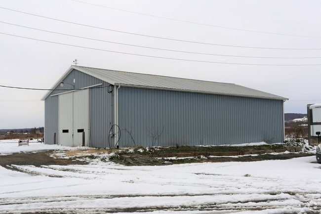
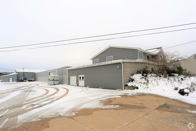
Property Record
4494 E Remington Rd, North East, PA 16428

NEARBY LISTINGS FOR SALE OR LEASE
-
-
View all North East listings for sale on LoopNet.com
Property Detail
4494 E Remington Rd
37-017-073.0-015.01
11871 E MAIN RD 2.11 AC CAL
Warehouse
Erie
X
Pennsylvania
42049C0110E
2.11 AC
2025
Outlying Erie County
2025
Erie
011702
Erie, PA
20,101 SF
DEMOGRAPHICS near 4494 E Remington Rd
1 Mile
3 Mile
5 Mile
2024 Total Population
112
8,681
10,879
2029 Population
112
8,601
10,744
Pop Growth 2024-2029
0.00%
(0.92%)
(1.24%)
Average Age
47
42
42
2024 Total Households
49
3,593
4,445
HH Growth 2024-2029
0.00%
(1.03%)
(1.33%)
Median Household Inc
$66,562
$58,260
$61,795
Avg Household Size
2.30
2.30
2.40
2024 Avg HH Vehicles
2.00
2.00
2.00
Median Home Value
$205,000
$152,690
$157,582
Median Year Built
1963
1963
1965
Nearby Places
Map Layers
Map Styles
 Street
 Aerial
- Restaurants
- Banks
- Shops
- Fitness
- Groceries
PUBLIC TRANSPORTATION
AIRPORT
Erie International/Tom Ridge Field
DRIVE
WALK
Distance
Erie International/Tom Ridge Field
41 min
26.0 mi
Freight Ports
Port of Toledo
DRIVE
WALK
Distance
Port of Toledo
272 min
231.1 mi
SALE & LEASE HISTORY
LISTING DATE
SALE/LEASE

Jul 14, 2017
For Sale
Dec 28, 2018
For Sale
Nearby Properties
Address
Land Use
TOTAL SIZE
Lot Size
Zoning
Address
Land Use
TOTAL SIZE
Lot Size
Zoning
21.27 AC
R2
Address
Land Use
TOTAL SIZE
Lot Size
Zoning
9.35 AC
Address
Land Use
TOTAL SIZE
Lot Size
Zoning
8.98 AC
R1
Address
Land Use
TOTAL SIZE
Lot Size
Zoning
6,705 SF
2.26 AC
R2
Address
Land Use
TOTAL SIZE
Lot Size
Zoning
56,285 SF
39.76 AC
I
Address
Land Use
TOTAL SIZE
Lot Size
Zoning
236,250 SF
23.67 AC
A
Address
Land Use
TOTAL SIZE
Lot Size
Zoning
240,000 SF
17.11 AC
R2
Address
Land Use
TOTAL SIZE
Lot Size
Zoning
3,633 SF
15.36 AC
R2
Address
Land Use
TOTAL SIZE
Lot Size
Zoning
380,939 SF
24.75 AC
M1
Address
Land Use
TOTAL SIZE
Lot Size
Zoning
96.88 AC
R2
Address
Land Use
TOTAL SIZE
Lot Size
Zoning
255,182 SF
50.87 AC
M1
Address
Land Use
TOTAL SIZE
Lot Size
Zoning
9,224 SF
22.15 AC
R2
Address
Land Use
TOTAL SIZE
Lot Size
Zoning
0.69 AC
C1
Address
Land Use
TOTAL SIZE
Lot Size
Zoning
4.93 AC
R1
Address
Land Use
TOTAL SIZE
Lot Size
Zoning
157,494 SF
9.30 AC
RB
Address
Land Use
TOTAL SIZE
Lot Size
Zoning
56,374 SF
15.91 AC
I
Address
Land Use
TOTAL SIZE
Lot Size
Zoning
7,874 SF
28 AC
Address
Land Use
TOTAL SIZE
Lot Size
Zoning
3.02 AC
RA
Address
Land Use
TOTAL SIZE
Lot Size
Zoning
40 AC
R2
Address
Land Use
TOTAL SIZE
Lot Size
Zoning
17,609 SF
2.88 AC
R2
Address
Land Use
TOTAL SIZE
Lot Size
Zoning
11,442 SF
5.11 AC
R2
Address
Land Use
TOTAL SIZE
Lot Size
Zoning
1.20 AC
Address
Land Use
TOTAL SIZE
Lot Size
Zoning
36,923 SF
0.91 AC
C1
Address
Land Use
TOTAL SIZE
Lot Size
Zoning
33,720 SF
2.59 AC
R2
Address
Land Use
TOTAL SIZE
Lot Size
Zoning
131,088 SF
2.88 AC
M1
Address
Land Use
TOTAL SIZE
Lot Size
Zoning
9,544 SF
10.58 AC
RA
Address
Land Use
TOTAL SIZE
Lot Size
Zoning
0.63 AC
C1
Address
Land Use
TOTAL SIZE
Lot Size
Zoning
449 SF
0.88 AC
R1
Address
Land Use
TOTAL SIZE
Lot Size
Zoning
260,703 SF
17.84 AC
M1
Address
Land Use
TOTAL SIZE
Lot Size
Zoning
18,484 SF
2.87 AC
R2
The World's #1 Commercial Real Estate Marketplace
Connect with us
© 2026 CoStar Group
The information above has been obtained from sources believed reliable. While we do not doubt its accuracy we have not verified it and make no guarantee, warranty or representation about it. It is your responsibility to independently confirm its accuracy and completeness. Any projections, opinions, assumptions, or estimates used are for example only and do not represent the current or future performance of the property. The value of this transaction to you depends on tax and other factors which should be evaluated by your tax, financial, and legal advisors. You and your advisors should conduct a careful, independent investigation of the property to determine to your satisfaction the suitability of the property for your needs.