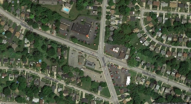
Property Record
4497 Harrison Ave, Cincinnati, OH 45211

NEARBY LISTINGS FOR SALE OR LEASE
Property Detail
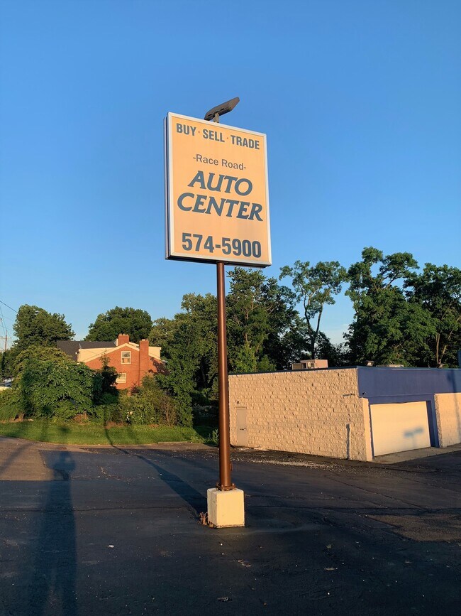
4497 Harrison Ave
Cincinnati, OH-KY-IN
Ring Est Sub
550-0121-0521
SEC HARRISON & RACE 0.4518 AC R2-T2-S15 PT LOT A - A RING EST
Vehiclerentalsvehiclesales
Hamilton
X
Ohio
39061C0192E
a
2025
0.47 AC
2025
Forest Park/West
010202
Cincinnati/Dayton
3,040 SF
DEMOGRAPHICS near 4497 Harrison Ave
1 Mile
3 Mile
5 Mile
2024 Total Population
11,291
77,403
208,724
2029 Population
10,977
75,907
206,383
Pop Growth 2024-2029
(2.78%)
(1.93%)
(1.12%)
Average Age
40
40
39
2024 Total Households
4,731
32,569
85,299
HH Growth 2024-2029
(2.96%)
(2.07%)
(1.24%)
Median Household Inc
$65,701
$63,502
$56,650
Avg Household Size
2.30
2.30
2.40
2024 Avg HH Vehicles
2.00
2.00
2.00
Median Home Value
$147,092
$173,084
$171,909
Median Year Built
1954
1963
1963
Nearby Places
Map Layers
Map Styles
 Street
 Aerial
- Restaurants
- Banks
- Shops
- Fitness
- Groceries
PUBLIC TRANSPORTATION
AIRPORT
Cincinnati/Northern Kentucky International
DRIVE
WALK
Distance
Cincinnati/Northern Kentucky International
38 min
20.6 mi
Freight Ports
Port Milwaukee
DRIVE
WALK
Distance
Port Milwaukee
423 min
366.3 mi
SALE & LEASE HISTORY
LISTING DATE
SALE/LEASE

Sep 25, 2016
For Lease
Sep 24, 2016
For Sale
Jun 30, 2021
For Lease
Dec 07, 2022
For Sale
Nearby Properties
Address
Land Use
TOTAL SIZE
Lot Size
Zoning
Address
Land Use
TOTAL SIZE
Lot Size
Zoning
Address
Land Use
TOTAL SIZE
Lot Size
Zoning
9.52 AC
B
Address
Land Use
TOTAL SIZE
Lot Size
Zoning
17,857 SF
26.60 AC
CGA
Address
Land Use
TOTAL SIZE
Lot Size
Zoning
474 SF
9.59 AC
A
Address
Land Use
TOTAL SIZE
Lot Size
Zoning
Address
Land Use
TOTAL SIZE
Lot Size
Zoning
2,678 SF
8.76 AC
Address
Land Use
TOTAL SIZE
Lot Size
Zoning
6,620 SF
16.91 AC
Address
Land Use
TOTAL SIZE
Lot Size
Zoning
14.43 AC
Address
Land Use
TOTAL SIZE
Lot Size
Zoning
Address
Land Use
TOTAL SIZE
Lot Size
Zoning
4.68 AC
E
Address
Land Use
TOTAL SIZE
Lot Size
Zoning
29,084 SF
30.10 AC
DD
Address
Land Use
TOTAL SIZE
Lot Size
Zoning
125,405 SF
16.69 AC
SF6
Address
Land Use
TOTAL SIZE
Lot Size
Zoning
360 SF
7.79 AC
F
Address
Land Use
TOTAL SIZE
Lot Size
Zoning
6,000 SF
11.92 AC
G
Address
Land Use
TOTAL SIZE
Lot Size
Zoning
8.57 AC
Address
Land Use
TOTAL SIZE
Lot Size
Zoning
62,160 SF
13.70 AC
RM20
Address
Land Use
TOTAL SIZE
Lot Size
Zoning
55,572 SF
6.12 AC
C
Address
Land Use
TOTAL SIZE
Lot Size
Zoning
19.52 AC
EE
Address
Land Use
TOTAL SIZE
Lot Size
Zoning
18.30 AC
EE
Address
Land Use
TOTAL SIZE
Lot Size
Zoning
14.01 AC
CGA
Address
Land Use
TOTAL SIZE
Lot Size
Zoning
40,080 SF
4.14 AC
SF6
Address
Land Use
TOTAL SIZE
Lot Size
Zoning
76,739 SF
11.44 AC
SF6
Address
Land Use
TOTAL SIZE
Lot Size
Zoning
4.28 AC
OO
Address
Land Use
TOTAL SIZE
Lot Size
Zoning
84,810 SF
12.66 AC
C
Address
Land Use
TOTAL SIZE
Lot Size
Zoning
24,222 SF
3.91 AC
CGA
Address
Land Use
TOTAL SIZE
Lot Size
Zoning
47,504 SF
14.37 AC
RM20
Address
Land Use
TOTAL SIZE
Lot Size
Zoning
60,751 SF
9.57 AC
C
Address
Land Use
TOTAL SIZE
Lot Size
Zoning
4.33 AC
Address
Land Use
TOTAL SIZE
Lot Size
Zoning
8,580 SF
19.31 AC
DD
Address
Land Use
TOTAL SIZE
Lot Size
Zoning
The World's #1 Commercial Real Estate Marketplace
Connect with us
© 2026 CoStar Group
The information above has been obtained from sources believed reliable. While we do not doubt its accuracy we have not verified it and make no guarantee, warranty or representation about it. It is your responsibility to independently confirm its accuracy and completeness. Any projections, opinions, assumptions, or estimates used are for example only and do not represent the current or future performance of the property. The value of this transaction to you depends on tax and other factors which should be evaluated by your tax, financial, and legal advisors. You and your advisors should conduct a careful, independent investigation of the property to determine to your satisfaction the suitability of the property for your needs.