Property Record
44W104 Us Highway 20, Hampshire, IL 60140
NEARBY LISTINGS FOR SALE OR LEASE
Property Detail
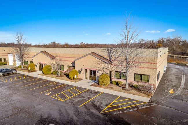
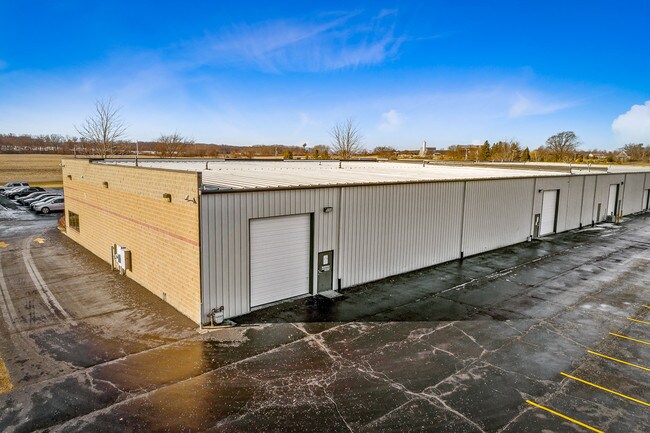
44W104 Us Highway 20
01-25-226-003
Hampshire Corporate Center Condo
Industrialgeneral
HAMPSHIRE CORPORATE CENTER CONDO - UNIT 2
X
Kane
17089C0126J
Illinois
2024
1.70 AC
2024
North Kane/I-90
850705
Chicago
11,164 SF
Chicago-Naperville-Elgin, IL-IN
DEMOGRAPHICS near 44W104 Us Highway 20
1 Mile
3 Mile
5 Mile
2024 Total Population
439
17,574
33,602
2029 Population
431
17,400
33,374
Pop Growth 2024-2029
(1.82%)
(0.99%)
(0.68%)
Average Age
36
38
47
2024 Total Households
154
6,225
13,816
HH Growth 2024-2029
(1.95%)
(1.08%)
(0.69%)
Median Household Inc
$112,053
$107,662
$89,498
Avg Household Size
2.90
2.80
2.40
2024 Avg HH Vehicles
2.00
2.00
2.00
Median Home Value
$394,444
$314,172
$315,030
Median Year Built
2005
2004
2003
Nearby Places
Map Layers
Map Styles
 Street
 Aerial
- Restaurants
- Banks
- Shops
- Fitness
- Groceries
PUBLIC TRANSPORTATION
COMMUTER RAIL
Big Timber Road Station (Milwaukee District West Line - Northeast Illinois Regional Commuter Railroad (Metra))
DRIVE
WALK
Distance
Big Timber Road Station (Milwaukee District West Line - Northeast Illinois Regional Commuter Railroad (Metra))
14 min
9.0 mi
Freight Ports
Port Milwaukee
DRIVE
WALK
Distance
Port Milwaukee
119 min
89.3 mi
SALE & LEASE HISTORY
LISTING DATE
SALE/LEASE

Jan 29, 2019
For Lease
Feb 21, 2019
For Sale
Dec 15, 2023
For Sale
Dec 14, 2023
For Lease
Dec 14, 2023
For Sale
Nearby Properties
Address
Land Use
TOTAL SIZE
Lot Size
Zoning
Address
Land Use
TOTAL SIZE
Lot Size
Zoning
10.30 AC
Address
Land Use
TOTAL SIZE
Lot Size
Zoning
15.02 AC
Address
Land Use
TOTAL SIZE
Lot Size
Zoning
89,940 SF
8.93 AC
Address
Land Use
TOTAL SIZE
Lot Size
Zoning
152,275 SF
12.22 AC
I DISTRICT
Address
Land Use
TOTAL SIZE
Lot Size
Zoning
14.26 AC
Address
Land Use
TOTAL SIZE
Lot Size
Zoning
44,800 SF
35.39 AC
M2 MANUFAC
Address
Land Use
TOTAL SIZE
Lot Size
Zoning
Address
Land Use
TOTAL SIZE
Lot Size
Zoning
41,122 SF
4.25 AC
Address
Land Use
TOTAL SIZE
Lot Size
Zoning
Address
Land Use
TOTAL SIZE
Lot Size
Zoning
1.75 AC
Address
Land Use
TOTAL SIZE
Lot Size
Zoning
101,250 SF
17.98 AC
Address
Land Use
TOTAL SIZE
Lot Size
Zoning
58,400 SF
10.26 AC
Address
Land Use
TOTAL SIZE
Lot Size
Zoning
Address
Land Use
TOTAL SIZE
Lot Size
Zoning
Address
Land Use
TOTAL SIZE
Lot Size
Zoning
Address
Land Use
TOTAL SIZE
Lot Size
Zoning
Address
Land Use
TOTAL SIZE
Lot Size
Zoning
2.80 AC
Address
Land Use
TOTAL SIZE
Lot Size
Zoning
162,846 SF
4.71 AC
Address
Land Use
TOTAL SIZE
Lot Size
Zoning
28,900 SF
9 AC
I DISTRICT
Address
Land Use
TOTAL SIZE
Lot Size
Zoning
23,626 SF
1.98 AC
I DISTRICT
Address
Land Use
TOTAL SIZE
Lot Size
Zoning
4.83 AC
Address
Land Use
TOTAL SIZE
Lot Size
Zoning
46,596 SF
5.66 AC
M1 MANUFAC
Address
Land Use
TOTAL SIZE
Lot Size
Zoning
Address
Land Use
TOTAL SIZE
Lot Size
Zoning
29,863 SF
3.27 AC
I DISTRICT
Address
Land Use
TOTAL SIZE
Lot Size
Zoning
16.90 AC
Address
Land Use
TOTAL SIZE
Lot Size
Zoning
23,754 SF
1.87 AC
I DISTRICT
Address
Land Use
TOTAL SIZE
Lot Size
Zoning
1.16 AC
Address
Land Use
TOTAL SIZE
Lot Size
Zoning
1.22 AC
Address
Land Use
TOTAL SIZE
Lot Size
Zoning
18,317 SF
2.06 AC
B2 DISTRIC
Address
Land Use
TOTAL SIZE
Lot Size
Zoning
4.13 AC
O-M OFFICE
The World's #1 Commercial Real Estate Marketplace
Connect with us
© 2026 CoStar Group
The information above has been obtained from sources believed reliable. While we do not doubt its accuracy we have not verified it and make no guarantee, warranty or representation about it. It is your responsibility to independently confirm its accuracy and completeness. Any projections, opinions, assumptions, or estimates used are for example only and do not represent the current or future performance of the property. The value of this transaction to you depends on tax and other factors which should be evaluated by your tax, financial, and legal advisors. You and your advisors should conduct a careful, independent investigation of the property to determine to your satisfaction the suitability of the property for your needs.