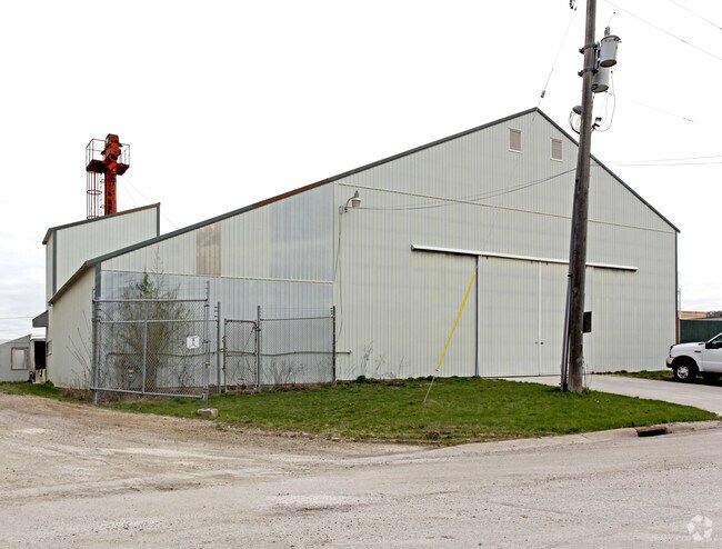
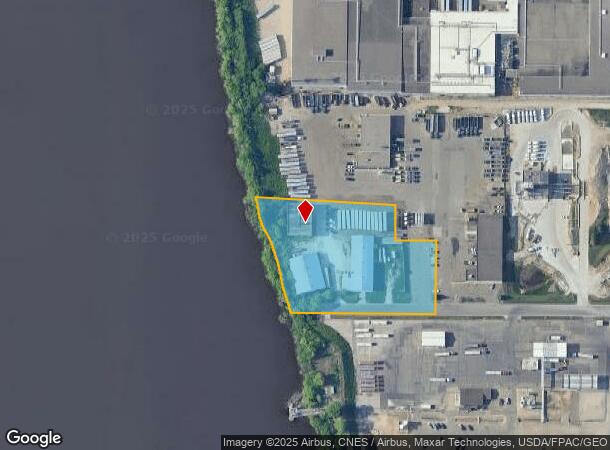
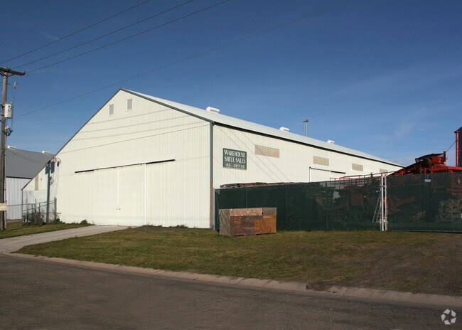
Property Record
45 21St St, Newport, MN 55055
NEARBY LISTINGS FOR SALE OR LEASE
Property Detail
45 21St St
26-028-22-42-0002
& EGRESS C/L OF WHICH IS DESC AS FOLL: BEG @ POINT ON S LN GV LOT 3 DIST 267.56 FT AS MEAS ALG SD S LN WLY OF POB OF ABOVE DE
Apartment
Washington
AE
Minnesota
27037C0044E
3
2025
2.92 AC
2024
East
071003
Minneapolis/St Paul
31,098 SF
Minneapolis-St. Paul-Bloomington, MN-WI
DEMOGRAPHICS near 45 21St St
1 Mile
3 Mile
5 Mile
2024 Total Population
2,473
57,528
170,478
2029 Population
2,772
59,484
177,619
Pop Growth 2024-2029
+ 12.09%
+ 3.40%
+ 4.19%
Average Age
39
40
39
2024 Total Households
975
23,237
66,210
HH Growth 2024-2029
+ 12.21%
+ 3.49%
+ 4.15%
Median Household Inc
$75,767
$76,204
$82,227
Avg Household Size
2.50
2.40
2.50
2024 Avg HH Vehicles
2.00
2.00
2.00
Median Home Value
$386,363
$274,946
$299,906
Median Year Built
1977
1976
1980
Nearby Places
Map Layers
Map Styles
 Street
 Aerial
- Restaurants
- Banks
- Shops
- Fitness
- Groceries
PUBLIC TRANSPORTATION
COMMUTER RAIL
St. Paul-Minneapolis (Empire Builder - Amtrak)
DRIVE
WALK
Distance
St. Paul-Minneapolis (Empire Builder - Amtrak)
12 min
8.3 mi
AIRPORT
Minneapolis-St Paul International/Wold-Chamberlain
DRIVE
WALK
Distance
Minneapolis-St Paul International/Wold-Chamberlain
21 min
12.7 mi
Freight Ports
Port Milwaukee
DRIVE
WALK
Distance
Port Milwaukee
362 min
328.4 mi
Nearby Properties
Address
Land Use
TOTAL SIZE
Lot Size
Zoning
Address
Land Use
TOTAL SIZE
Lot Size
Zoning
Address
Land Use
TOTAL SIZE
Lot Size
Zoning
146,085 SF
46.83 AC
Address
Land Use
TOTAL SIZE
Lot Size
Zoning
243,476 SF
14.87 AC
Address
Land Use
TOTAL SIZE
Lot Size
Zoning
293,970 SF
31.92 AC
Address
Land Use
TOTAL SIZE
Lot Size
Zoning
196,078 SF
31.29 AC
Address
Land Use
TOTAL SIZE
Lot Size
Zoning
228,050 SF
0.32 AC
Address
Land Use
TOTAL SIZE
Lot Size
Zoning
71,164 SF
10.79 AC
Address
Land Use
TOTAL SIZE
Lot Size
Zoning
163,985 SF
7.06 AC
Address
Land Use
TOTAL SIZE
Lot Size
Zoning
169,237 SF
23.38 AC
Address
Land Use
TOTAL SIZE
Lot Size
Zoning
482,008 SF
23.78 AC
Address
Land Use
TOTAL SIZE
Lot Size
Zoning
452,836 SF
17.81 AC
Address
Land Use
TOTAL SIZE
Lot Size
Zoning
Address
Land Use
TOTAL SIZE
Lot Size
Zoning
52,294 SF
6.47 AC
Address
Land Use
TOTAL SIZE
Lot Size
Zoning
229,442 SF
9.50 AC
Address
Land Use
TOTAL SIZE
Lot Size
Zoning
138,609 SF
3.76 AC
Address
Land Use
TOTAL SIZE
Lot Size
Zoning
160,669 SF
5.10 AC
Address
Land Use
TOTAL SIZE
Lot Size
Zoning
106,894 SF
5.88 AC
Address
Land Use
TOTAL SIZE
Lot Size
Zoning
41,040 SF
11.38 AC
Address
Land Use
TOTAL SIZE
Lot Size
Zoning
123,226 SF
9.50 AC
Address
Land Use
TOTAL SIZE
Lot Size
Zoning
236,378 SF
7.57 AC
Address
Land Use
TOTAL SIZE
Lot Size
Zoning
150,469 SF
10.73 AC
Address
Land Use
TOTAL SIZE
Lot Size
Zoning
152,098 SF
8.23 AC
Address
Land Use
TOTAL SIZE
Lot Size
Zoning
174,820 SF
7.79 AC
Address
Land Use
TOTAL SIZE
Lot Size
Zoning
28,461 SF
16.13 AC
Address
Land Use
TOTAL SIZE
Lot Size
Zoning
134,252 SF
8.53 AC
Address
Land Use
TOTAL SIZE
Lot Size
Zoning
191,349 SF
5.10 AC
Address
Land Use
TOTAL SIZE
Lot Size
Zoning
64,742 SF
3.56 AC
Address
Land Use
TOTAL SIZE
Lot Size
Zoning
151,959 SF
0.32 AC
Address
Land Use
TOTAL SIZE
Lot Size
Zoning
219,438 SF
90.20 AC
Address
Land Use
TOTAL SIZE
Lot Size
Zoning
111,334 SF
38.36 AC
The World's #1 Commercial Real Estate Marketplace
Connect with us
© 2025 CoStar Group
The information above has been obtained from sources believed reliable. While we do not doubt its accuracy we have not verified it and make no guarantee, warranty or representation about it. It is your responsibility to independently confirm its accuracy and completeness. Any projections, opinions, assumptions, or estimates used are for example only and do not represent the current or future performance of the property. The value of this transaction to you depends on tax and other factors which should be evaluated by your tax, financial, and legal advisors. You and your advisors should conduct a careful, independent investigation of the property to determine to your satisfaction the suitability of the property for your needs.