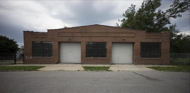
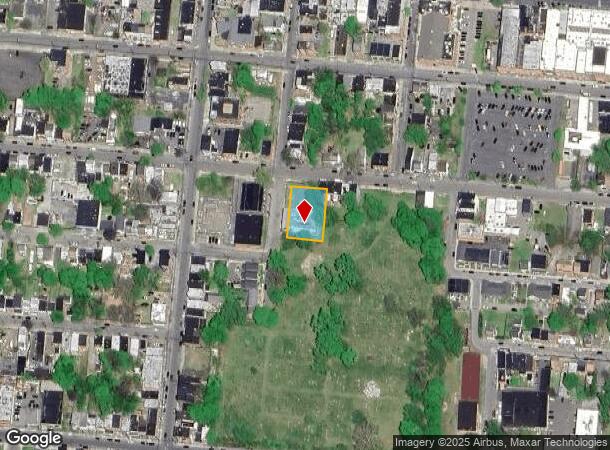
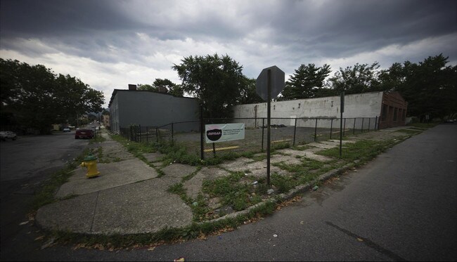
Property Record
45 Clark St, Newburgh, NY 12550
NEARBY LISTINGS FOR SALE OR LEASE
Property Detail
45 Clark St
331100-039-000-0002-006.100-0000
Orange
Warehouse
New York
X
6.100
36071C0332E
0.35 AC
2024
Orange County
2024
Northern New Jersey
014101
Kiryas Joel-Poughkeepsie-Newburgh, NY
6,936 SF
DEMOGRAPHICS near 45 Clark St
1 Mile
3 Mile
5 Mile
2024 Total Population
22,263
61,853
107,651
2029 Population
22,532
62,644
109,315
Pop Growth 2024-2029
+ 1.21%
+ 1.28%
+ 1.55%
Average Age
34
39
40
2024 Total Households
7,492
23,383
40,576
HH Growth 2024-2029
+ 1.40%
+ 1.31%
+ 1.60%
Median Household Inc
$46,861
$72,399
$84,171
Avg Household Size
2.80
2.50
2.50
2024 Avg HH Vehicles
1.00
2.00
2.00
Median Home Value
$172,459
$284,609
$313,480
Median Year Built
1946
1956
1965
Nearby Places
Map Layers
Map Styles
 Street
 Aerial
- Restaurants
- Banks
- Shops
- Fitness
- Groceries
PUBLIC TRANSPORTATION
COMMUTER RAIL
Beacon Station (Hudson Line - Metro-North Commuter Railroad Company (Metro-North))
DRIVE
WALK
Distance
Beacon Station (Hudson Line - Metro-North Commuter Railroad Company (Metro-North))
11 min
5.4 mi
Salisbury Mills Cornwall (Bergen County/Port Jervis Line - NJ Transit Commuter Rail (NJ Transit), Main/Port Jervis Line - NJ Transit Commuter Rail (NJ Transit))
DRIVE
WALK
Distance
Salisbury Mills Cornwall (Bergen County/Port Jervis Line - NJ Transit Commuter Rail (NJ Transit), Main/Port Jervis Line - NJ Transit Commuter Rail (NJ Transit))
15 min
7.3 mi
AIRPORT
New York Stewart International
DRIVE
WALK
Distance
New York Stewart International
13 min
6.5 mi
SALE & LEASE HISTORY
LISTING DATE
SALE/LEASE

Mar 09, 2020
For Lease
Aug 15, 2017
For Lease
Nearby Properties
Address
Land Use
TOTAL SIZE
Lot Size
Zoning
Address
Land Use
TOTAL SIZE
Lot Size
Zoning
211,240 SF
5.30 AC
WG
Address
Land Use
TOTAL SIZE
Lot Size
Zoning
325,026 SF
6.30 AC
RM
Address
Land Use
TOTAL SIZE
Lot Size
Zoning
251,689 SF
43.70 AC
RMF5
Address
Land Use
TOTAL SIZE
Lot Size
Zoning
17.59 AC
R1-40
Address
Land Use
TOTAL SIZE
Lot Size
Zoning
355,349 SF
28.50 AC
RM
Address
Land Use
TOTAL SIZE
Lot Size
Zoning
345,572 SF
43.80 AC
R-1
Address
Land Use
TOTAL SIZE
Lot Size
Zoning
7.96 AC
RD-1.8
Address
Land Use
TOTAL SIZE
Lot Size
Zoning
88,103 SF
32.60 AC
RH
Address
Land Use
TOTAL SIZE
Lot Size
Zoning
927,041 SF
104.37 AC
Address
Land Use
TOTAL SIZE
Lot Size
Zoning
272,943 SF
17 AC
RL
Address
Land Use
TOTAL SIZE
Lot Size
Zoning
110,384 SF
13.10 AC
RM
Address
Land Use
TOTAL SIZE
Lot Size
Zoning
112,136 SF
2.70 AC
RM
Address
Land Use
TOTAL SIZE
Lot Size
Zoning
45.48 AC
HI
Address
Land Use
TOTAL SIZE
Lot Size
Zoning
10,746 SF
11 AC
PWD
Address
Land Use
TOTAL SIZE
Lot Size
Zoning
7.65 AC
RMF-5
Address
Land Use
TOTAL SIZE
Lot Size
Zoning
182,318 SF
9.20 AC
RL
Address
Land Use
TOTAL SIZE
Lot Size
Zoning
200 SF
11.97 AC
RD-3
Address
Land Use
TOTAL SIZE
Lot Size
Zoning
38,962 SF
16.80 AC
RMF5
Address
Land Use
TOTAL SIZE
Lot Size
Zoning
38.66 AC
R1-40
Address
Land Use
TOTAL SIZE
Lot Size
Zoning
20.50 AC
Address
Land Use
TOTAL SIZE
Lot Size
Zoning
91,705 SF
1.90 AC
RM
Address
Land Use
TOTAL SIZE
Lot Size
Zoning
5.70 AC
RD-3
Address
Land Use
TOTAL SIZE
Lot Size
Zoning
9.17 AC
RD-3
Address
Land Use
TOTAL SIZE
Lot Size
Zoning
1.20 AC
Address
Land Use
TOTAL SIZE
Lot Size
Zoning
176,680 SF
1.28 AC
RM
Address
Land Use
TOTAL SIZE
Lot Size
Zoning
82,344 SF
1.80 AC
RH
Address
Land Use
TOTAL SIZE
Lot Size
Zoning
59,220 SF
6.40 AC
CD
Address
Land Use
TOTAL SIZE
Lot Size
Zoning
16.32 AC
RD-3
Address
Land Use
TOTAL SIZE
Lot Size
Zoning
69,006 SF
1.77 AC
DN
Address
Land Use
TOTAL SIZE
Lot Size
Zoning
213,521 SF
8 AC
RH
The World's #1 Commercial Real Estate Marketplace
Connect with us
© 2026 CoStar Group
The information above has been obtained from sources believed reliable. While we do not doubt its accuracy we have not verified it and make no guarantee, warranty or representation about it. It is your responsibility to independently confirm its accuracy and completeness. Any projections, opinions, assumptions, or estimates used are for example only and do not represent the current or future performance of the property. The value of this transaction to you depends on tax and other factors which should be evaluated by your tax, financial, and legal advisors. You and your advisors should conduct a careful, independent investigation of the property to determine to your satisfaction the suitability of the property for your needs.