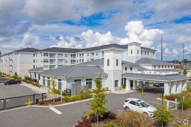
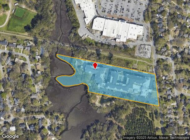
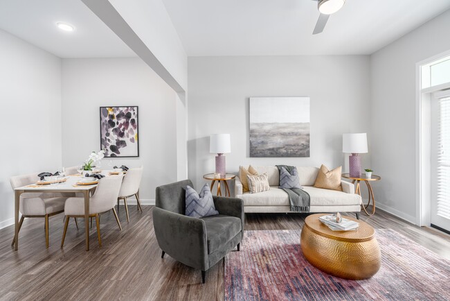
Property Record
45 Coburg Rd, Charleston, SC 29407
NEARBY LISTINGS FOR SALE OR LEASE
Property Detail
45 Coburg Rd
Charleston-North Charleston, SC
Coburg
349-08-00-001
MAPPLATB L17 MAPPLATP 0217 SUBDIVISIONNAME CHARLESTON TRACT G
Apartment
Charleston
AE
South Carolina
45019C0513K
7.09 AC
2025
West Ashley
2024
Charleston/N Charleston
003000
DEMOGRAPHICS near 45 Coburg Rd
1 Mile
3 Mile
5 Mile
2024 Total Population
7,406
62,143
135,302
2029 Population
7,899
66,699
145,510
Pop Growth 2024-2029
+ 6.66%
+ 7.33%
+ 7.54%
Average Age
41
39
39
2024 Total Households
3,534
28,748
60,875
HH Growth 2024-2029
+ 6.48%
+ 7.28%
+ 7.50%
Median Household Inc
$86,069
$70,889
$70,518
Avg Household Size
2.10
2.00
2.10
2024 Avg HH Vehicles
2.00
2.00
2.00
Median Home Value
$447,779
$415,403
$395,223
Median Year Built
1960
1968
1976
Nearby Places
Map Layers
Map Styles
 Street
 Aerial
- Restaurants
- Banks
- Shops
- Fitness
- Groceries
PUBLIC TRANSPORTATION
COMMUTER RAIL
Charleston Amtrak Station (Palmetto - Amtrak, Silver Meteor - Amtrak)
DRIVE
WALK
Distance
Charleston Amtrak Station (Palmetto - Amtrak, Silver Meteor - Amtrak)
15 min
7.7 mi
AIRPORT
Charleston AFB/International
DRIVE
WALK
Distance
Charleston AFB/International
21 min
13.1 mi
Freight Ports
Columbus Street Terminal
DRIVE
WALK
Distance
Columbus Street Terminal
9 min
4.0 mi
Nearby Properties
Address
Land Use
TOTAL SIZE
Lot Size
Zoning
Address
Land Use
TOTAL SIZE
Lot Size
Zoning
0.62 AC
Address
Land Use
TOTAL SIZE
Lot Size
Zoning
80,044 SF
2.48 AC
Address
Land Use
TOTAL SIZE
Lot Size
Zoning
21,900 SF
5.96 AC
Address
Land Use
TOTAL SIZE
Lot Size
Zoning
66,136 SF
1.88 AC
Address
Land Use
TOTAL SIZE
Lot Size
Zoning
78,810 SF
3.33 AC
Address
Land Use
TOTAL SIZE
Lot Size
Zoning
1,435 SF
1.98 AC
Address
Land Use
TOTAL SIZE
Lot Size
Zoning
17,459 SF
4.16 AC
Address
Land Use
TOTAL SIZE
Lot Size
Zoning
8,714 SF
1.60 AC
Address
Land Use
TOTAL SIZE
Lot Size
Zoning
30,196 SF
1.58 AC
Address
Land Use
TOTAL SIZE
Lot Size
Zoning
Address
Land Use
TOTAL SIZE
Lot Size
Zoning
Address
Land Use
TOTAL SIZE
Lot Size
Zoning
43,934 SF
1.50 AC
Address
Land Use
TOTAL SIZE
Lot Size
Zoning
3,520 SF
7.70 AC
Address
Land Use
TOTAL SIZE
Lot Size
Zoning
41,070 SF
0.61 AC
Address
Land Use
TOTAL SIZE
Lot Size
Zoning
Address
Land Use
TOTAL SIZE
Lot Size
Zoning
22,825 SF
4.36 AC
Address
Land Use
TOTAL SIZE
Lot Size
Zoning
257,500 SF
4.72 AC
Address
Land Use
TOTAL SIZE
Lot Size
Zoning
12,766 SF
1.72 AC
Address
Land Use
TOTAL SIZE
Lot Size
Zoning
Address
Land Use
TOTAL SIZE
Lot Size
Zoning
Address
Land Use
TOTAL SIZE
Lot Size
Zoning
26,010 SF
4.32 AC
Address
Land Use
TOTAL SIZE
Lot Size
Zoning
1,056 SF
1.65 AC
Address
Land Use
TOTAL SIZE
Lot Size
Zoning
34,609 SF
3.57 AC
Address
Land Use
TOTAL SIZE
Lot Size
Zoning
25,749 SF
2.49 AC
Address
Land Use
TOTAL SIZE
Lot Size
Zoning
Address
Land Use
TOTAL SIZE
Lot Size
Zoning
0.60 AC
Address
Land Use
TOTAL SIZE
Lot Size
Zoning
1,793 SF
Address
Land Use
TOTAL SIZE
Lot Size
Zoning
1.08 AC
Address
Land Use
TOTAL SIZE
Lot Size
Zoning
172,224 SF
7.35 AC
The World's #1 Commercial Real Estate Marketplace
Connect with us
© 2026 CoStar Group
The information above has been obtained from sources believed reliable. While we do not doubt its accuracy we have not verified it and make no guarantee, warranty or representation about it. It is your responsibility to independently confirm its accuracy and completeness. Any projections, opinions, assumptions, or estimates used are for example only and do not represent the current or future performance of the property. The value of this transaction to you depends on tax and other factors which should be evaluated by your tax, financial, and legal advisors. You and your advisors should conduct a careful, independent investigation of the property to determine to your satisfaction the suitability of the property for your needs.